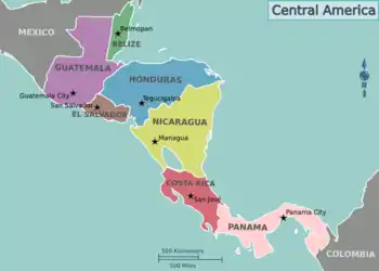
Belize–Guatemala border
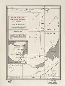
The Belize–Guatemala border is an almost straight line 266 km (165 mi) long, close to the 89th meridian west, which separates the west of Belize's territory from Guatemala's.


Border description and history
The border between Belize and Guatemala is defined in Article I of the Wyke–Aycinena Treaty of 1859:[1][2]
Beginning at the mouth of the River Sarstoon in the Bay of Honduras, and proceeding up the mid-channel thereof to Gracias a Dios Falls; then turning to the right and continuing by a line drawn direct from Gracias a Dios Falls to Garbutt's Falls on the River Belize, and from Garbutt's Falls due north until it strikes the Mexican frontier.
The border has been disputed by Guatemala, which claims that the treaty is void since Britain failed to comply with economic assistance provisions found in Article VII. The situation was partially resolved in 1991 when Guatemala officially recognized Belize's independence and diplomatic relations were established.
Border communities and crossings
There is one main highway crossing of the border, at Benque Viejo del Carmen, Cayo District, Belize and Melchor de Mencos, Peten, Guatemala, where Guatemala Highway CA-13 meets the George Price (Western) Highway, connecting to Belize City and Belmopan.
About four kilometres south of this crossing is the village of Arenal, which has homes on both sides of the border, and a football field directly on the border. From the Guatemala side, there is just a footbridge to a road into Melchor de Mencos; the Belize side has a road connecting to Benque Viejo.
References
- Aycinena-Wyke Treaty (PDF), 1859, retrieved March 15, 2016
- Ministerio de Relaciones Exteriores de Guatemala. "Histórica del Diferendo Territorial" (PDF) (in Spanish). Retrieved 15 May 2011.