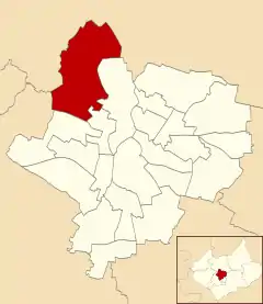
Beaumont Leys
Beaumont Leys is a suburb and electoral ward in north-western Leicester, England. The population of the ward at the 2011 census was 16,480.[1] Locally, Beaumont Leys is usually used in reference to the large housing estate, built within the administrative division, centred on Strasbourg Drive.
| Beaumont Leys | |
|---|---|
 Beaumont Leys Shopping Centre in November 2005 | |
 | |
| Population | 16,480 (2011) |
| Unitary authority | |
| Ceremonial county | |
| Region | |
| Country | England |
| Sovereign state | United Kingdom |
| Post town | LEICESTER |
| Postcode district | LE4 |
| Dialling code | 0116 |
| Police | Leicestershire |
| Fire | Leicestershire |
| Ambulance | East Midlands |
| UK Parliament | |
Geography
Beaumont Leys is located within the city boundary of Leicester, although prior to the 2011 census, the Office for National Statistics considered Beaumont Leys as an environ, distinct from the city. Beaumont Leys is bordered by the wards of Abbey to the east, Fosse to the south-east and New Parks to the south.[2] North and west of the area are the Leicestershire villages of Anstey and Glenfield.
History
The area before the 1970s was mainly farmland and a sewage system, however started to be invested in by the council and local private housing companies. The area was largely developed from the 1970s onwards, and continues to expand into the surrounding countryside. It includes several large housing estates, industrial areas (including the main factory for Walkers) and a large area of modern housing (some of it known as "Anstey Heights").[3]
Newer areas of Beaumont Leys include the Anstey Heights, towards Castle Hill Park and the village of Anstey, as well as the Thurcaston Park housing developments on the North side of Beaumont Leys and Bradgate Heights on the land surrounded by Glenfield, Anstey and Beaumont Leys. The Thurcaston Park development is expected to have 2000 homes once the estate is finished.
Amenities and facilities
The Beaumont Shopping Centre is the main facility, one of the largest shopping areas in the city suburbs; and a church, a large leisure centre, a library and a police station are nearby. Smaller shopping precincts tend to be on land that was previously occupied by farms.
There are also several schools including Babington Academy and Beaumont Leys School. The latter is now a specialised science school and was rebuilt in 2009 with a City Learning Centre built next to it.
Primary schools in the area include Beaumont lodge Primary school, heatherbrook primary school and Glebelands primary school.
The area includes a large industrial estate, which includes the main Walkers Crisps factory and Office Depot, as well as a smaller industrial estate to the south.
The Leicester Lions speedway team compete in the Elite League and their home track is at Beaumont Park.
Transport
Beaumont Leys is mainly served by First Leicester and Centrebus.
The A46 trunk road bypasses Beaumont Leys and is accessible by the Anstey Junction. The A46 leads on to the M1
References
| Wikimedia Commons has media related to Beaumont Leys. |
- "Ward population 2011". Neighbourhood Statistics. Office for National Statistics. Retrieved 4 June 2016.
- Leicester City Council. "Ward Maps". Archived from the original on 13 June 2011. Retrieved 11 October 2011.
- Lead Neighbourhood Summary