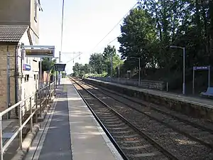
Ashwell & Morden railway station
Ashwell & Morden railway station is a wayside railway station in Cambridgeshire, England. Close to the border with the county of Hertfordshire, it is in the hamlet of Odsey, slightly north of the Icknield Way, a Roman Road that is now the A505. It is 41 miles (65.98 km) down the line from London King's Cross. Train services are currently operated by Thameslink.[1]
 | |
| Location | Odsey, South Cambridgeshire England |
| Coordinates | 52.031°N 0.110°W |
| Grid reference | TL298386 |
| Managed by | Great Northern |
| Platforms | 2 |
| Other information | |
| Station code | AWM |
| Classification | DfT category E |
| History | |
| Original company | Royston and Hitchin Railway |
| Pre-grouping | Great Northern Railway |
| Post-grouping | London and North Eastern Railway |
| Key dates | |
| 21 October 1850 | Opened as Ashwell |
| 1 April 1920 | Renamed Ashwell & Morden |
| Passengers | |
| 2015/16 | |
| 2016/17 | |
| 2017/18 | |
| 2018/19 | |
| 2019/20 | |
| Notes | |
Passenger statistics from the Office of Rail and Road | |
The villages it serves, as well as Odsey, are Ashwell, Guilden Morden and Steeple Morden, although it is located a couple of miles from each of them and linked to them only by minor roads.
History
Opened as Ashwell station by the Royston and Hitchin Railway (R&HR) on 21 October 1850,[2] the R&HR was later absorbed by the Great Northern Railway (GNR). The name was changed to Ashwell and Morden on 1 April 1920[2] three years before the GNR amalgamated with several other railways to form the London and North Eastern Railway during the Grouping of 1923. The station then passed on to the Eastern Region of British Railways on nationalisation in 1948.
When Sectorisation was introduced in the 1980s, the station was served by Network SouthEast until the Privatisation of British Railways.
Services
All services at Ashwell & Morden are operated by Thameslink. As of December 2019 the current off-peak service in trains per hour (tph) is:
- 2 tph to London Kings Cross (stopping)
- 1 tph to Brighton (semi-fast)
- 3 tph to Cambridge
| Preceding station | Following station | |||
|---|---|---|---|---|
| Thameslink | ||||
| Thameslink | ||||
References
External links
- Train times and station information for Ashwell & Morden railway station from National Rail