Ashford, South Australia
Ashford is an inner southwestern suburb of Adelaide, in the City of West Torrens. It is triangular in shape and bordered by South Road (west), Anzac Highway (southeast) and Everard Avenue (north). Two of the main features of the suburb are Ashford Hospital and Ashford Special School.[3]
| Ashford Adelaide, South Australia | |||||||||||||||
|---|---|---|---|---|---|---|---|---|---|---|---|---|---|---|---|
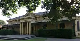 Ashford House, now part of the Ashford Special School | |||||||||||||||
| Population |
| ||||||||||||||
| Postcode(s) | 5035 | ||||||||||||||
| LGA(s) | City of West Torrens | ||||||||||||||
| State electorate(s) | Badcoe | ||||||||||||||
| Federal Division(s) | Adelaide | ||||||||||||||
| |||||||||||||||
Brownhill Creek flows through Ashford in a cement channel behind the school.
The name commemorates the property and residence (now part of Ashford Special School) of Dr. Charles George Everard, who settled in the area in 1838, and named it for Ashford in Kent.
References
- Australian Bureau of Statistics (27 June 2017). "Ashford (State Suburb)". 2016 Census QuickStats. Retrieved 22 December 2017.

- Australian Bureau of Statistics (31 October 2012). "Ashford (State Suburb)". 2011 Census QuickStats. Retrieved 31 December 2012.
- Ashford Special School, ashfordsp.sa.edu.au
 The SA Ambulance Service station, located at the intersection of Everard Avenue and Alexander Avenue
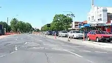 Anzac Highway, looking NE towards the city, with Ashford on the left and Everard Park on the right
This article is issued from Wikipedia. The text is licensed under Creative Commons - Attribution - Sharealike. Additional terms may apply for the media files.