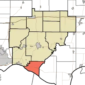
Anderson Township, Warrick County, Indiana
Anderson Township is one of ten townships in Warrick County, Indiana, United States. As of the 2010 census, its population was 1,274 and it contained 500 housing units.[1]
Anderson Township Warrick County | |
|---|---|
 Ohio River shoreline at the Yankeetown Site | |
 Location in Warrick County | |
| Coordinates: 37°56′00″N 87°18′09″W | |
| Country | United States |
| State | Indiana |
| County | Warrick |
| Government | |
| • Type | Indiana township |
| Area | |
| • Total | 22.13 sq mi (57.3 km2) |
| • Land | 20.72 sq mi (53.7 km2) |
| • Water | 1.41 sq mi (3.7 km2) 6.37% |
| Elevation | 427 ft (130 m) |
| Population (2010) | |
| • Total | 1,274 |
| • Density | 61.5/sq mi (23.7/km2) |
| ZIP codes | 47601, 47630 |
| GNIS feature ID | 453090 |
History
Southern Anderson Township is the location of the Yankeetown Site, an important archaeological site from the Woodland and Mississippian periods.[2]
Anderson Township was established in 1813.[3] The township was named for Bailey Anderson, a pioneer settler.[4]
Geography
According to the 2010 census, the township has a total area of 22.13 square miles (57.3 km2), of which 20.72 square miles (53.7 km2) (or 93.63%) is land and 1.41 square miles (3.7 km2) (or 6.37%) is water.[1]
Cities, towns, villages
- Newburgh (east edge)
Unincorporated towns
- Dayville at 37.954212°N 87.322228°W
- Red Brush at 37.938379°N 87.271948°W
- Vanada at 37.932267°N 87.364451°W
- Yankeetown at 37.917546°N 87.297782°W
(This list is based on USGS data and may include former settlements.)
Adjacent townships
- Boon Township (north)
- Luce Township, Spencer County (east)
- Ohio Township (northwest)
Cemeteries
The township contains Bates Hill Cemetery.
Rivers
Lakes
- Collins Lake
School districts
- Warrick County School Corporation
Political districts
- Indiana's 8th congressional district
- State House District 74
- State House District 78
- State Senate District 47
- State Senate District 50
References
- "Anderson Township, Warrick County, Indiana". Geographic Names Information System. United States Geological Survey. Retrieved 2009-09-24.
- United States Census Bureau 2007 TIGER/Line Shapefiles
- IndianaMap
- "Population, Housing Units, Area, and Density: 2010 - County -- County Subdivision and Place -- 2010 Census Summary File 1". United States Census. Archived from the original on 2020-02-12. Retrieved 2013-05-10.
- Curry, Hilda J. Archaeological Notes on Warrick County Indiana. Indianapolis: Indiana Historical Bureau, 1954, 13.
- Barr, Arvil Sylvester (1915). A History of Warrick County, Indiana, Prior to 1820, Including a Sketch of Methodism in the County Down to 1850. Indiana University. p. 17.
- History of Warrick, Spencer, and Perry Counties, Indiana: From the Earliest Time to the Present. Goodspeed. 1885. p. 23.
This article is issued from Wikipedia. The text is licensed under Creative Commons - Attribution - Sharealike. Additional terms may apply for the media files.