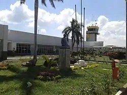
Alfonso López Pumarejo Airport
Alfonso López Pumarejo Airport (Spanish: Aeropuerto Alfonso López Pumarejo) (IATA: VUP, ICAO: SKVP) serves as air terminal for the city of Valledupar, Colombia and as a small Colombian Air Force and Colombian Police air base. The airport is operated by Aerocivil and three commercial passenger airlines as well as two cargo ones serve the airport, the passenger airlines being LAN Colombia, EasyFly and Avianca.
Alfonso López Pumarejo Airport Aeropuerto Alfonso López Pumarejo | |||||||||||
|---|---|---|---|---|---|---|---|---|---|---|---|
 | |||||||||||
| Summary | |||||||||||
| Airport type | Public | ||||||||||
| Operator | Aerocivil Colombia | ||||||||||
| Serves | Valledupar, Colombia | ||||||||||
| Elevation AMSL | 485 ft / 148 m | ||||||||||
| Coordinates | 10°26′00″N 73°14′59″W | ||||||||||
| Map | |||||||||||
 VUP Location of the airport in Colombia | |||||||||||
| Runways | |||||||||||
| |||||||||||
| Statistics (2011) | |||||||||||
| |||||||||||
The Valledupar non-directional beacon (Ident: VUP) is located on the field. The Valledupar VOR-DME (Ident: VVP) is located 5.9 nautical miles (10.9 km) south of the airport.[3][4]
Airlines and destinations
| Airlines | Destinations |
|---|---|
| Avianca | Bogotá |
| EasyFly | Barranquilla |
| LATAM Colombia | Bogotá |
References
- World Aero Data
- Airport information for VUP at Great Circle Mapper.
- Valledupar NDB
- Valledupar VOR
External links
- Valledupar Airport at OpenStreetMap
- Valledupar Airport at OurAirports
- Aeronautical chart and airport information for Valledupar Airport at SkyVector
- Valledupar Airport at FallingRain
- Accident history for VUP at Aviation Safety Network
- Current weather for SKVP at NOAA/NWS
This article is issued from Wikipedia. The text is licensed under Creative Commons - Attribution - Sharealike. Additional terms may apply for the media files.