2002 Oman cyclone
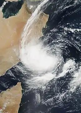
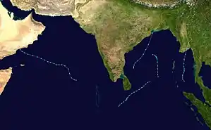
The 2002 Oman cyclone (JTWC designation: 01A, officially known as Cyclonic Storm ARB 01[1]) was a tropical cyclone that struck the Dhofar region of Oman in May 2002. The first storm of the 2002 North Indian Ocean cyclone season, it developed on May 6 in the Arabian Sea, and it maintained a general west-northwest track for much of its duration. The system reached cyclonic storm status on May 9, meaning it attained winds of greater than 65 km/h (40 mph), and on May 10 it made landfall near Salalah; shortly thereafter it dissipated. The storm was rare, in the sense that it was one of only twelve tropical cyclones on record to approach the Arabian Peninsula in the month of May.[1]
| Cyclonic storm (IMD scale) | |
|---|---|
| Tropical storm (SSHWS) | |
 The cyclone near peak intensity prior to landfall on May 9 | |
| Formed | May 6, 2002 |
| Dissipated | May 10, 2002 |
| Highest winds | 3-minute sustained: 65 km/h (40 mph) 1-minute sustained: 85 km/h (50 mph) |
| Lowest pressure | 991 hPa (mbar); 29.26 inHg (Unofficial estimate) |
| Fatalities | 9 total |
| Damage | $25 million (2002 USD) |
| Areas affected | Oman, Yemen |
| Part of the 2002 North Indian Ocean cyclone season | |
The storm brought the heaviest number of people to Dhofar in 30 years, causing flooding and creating rivers in wadis, or typically dry riverbeds. Several people drowned after their vehicles were swept away by the flooding. The storm caused locally heavy damage, totaling $25 million (2002 USD).
Meteorological history

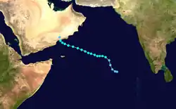
An area of convection developed on May 2, 2002 near Sri Lanka, associated with a weak and broad circulation center. The system tracked west-northwestward through the Arabian Sea along a trough near the equator. Its thunderstorm activity was enhanced by a ridge to its north, though was also removed from the center. By May 5, the circulation had become better defined, and concurrently the convection increased over the center.[2] After further organization, the India Meteorological Department (IMD) classified the system as Depression ARB01A on May 6.[1] Around the same time, the Joint Typhoon Warning Center (JTWC) classified it as Tropical Depression 01A, while located about 1300 km (800 mi) southeast of Salalah, Oman.[2]
After becoming a tropical cyclone, the depression turned to a northwest motion before resuming a track to the west-northwest. On May 7 it intensified into a deep depression,[1] and though its winds had increased, the structure became disorganized as the center became exposed from the thunderstorm activity. The convection waned, due to the influence of dry air from the Arabian Peninsula, as well as from wind shear.[2] As a result, the IMD downgraded it to depression status early on May 8.[1] However, later in the day, convection redeveloped over the western half of the circulation,[2] and it again reached deep depression status, about 830 km (515 mi) southeast of Oman.[1]
The storm maintained poleward outflow as it continued west-northwestward. Early on May 9 the IMD upgraded the system to a cyclonic storm,[1] estimating winds of 65 km/h (40 mph) and a pressure of 994 mbar (29.4 inHg).[3] Around that time, the storm was estimated by the JTWC to have attained peak winds of 85 km/h (50 km/h),[2] with an atmospheric pressure of 991 mbar.[4] While located a short distance offshore, the storm turned to the northwest and weakened slightly. At about 0900 UTC on May 10, the storm made landfall near Salalah, Oman. Shortly thereafter, it began dissipation over Oman.[2] Its landfall in the Dhofar region of Oman was uncommon; in the period from 1891 to 1990, only 17 tropical depressions or storms struck the region.[5]
Impact
.jpg.webp)
Along the coastline, the arrival of the storm resulted in strong waves of up to 4 metres (13 ft).[1] The storm dropped heavy rainfall in the vicinity of its landfall,[1] which were the greatest totals in 30 years in the Dhofar region.[6] The city of Salalah reported 58 mm (2.28 in) in a 24‑hour period as the storm moved ashore, which was more than 300% of its average monthly for May.[7] As a result, some flooding was reported in the city,[1] and several wadis, or typically dry riverbeds, became sudden rivers in the area; one station recorded a discharge of 1146 m3/s (40,470 ft3/s).[5] In Qairoon, precipitation amounted to 251 mm (9.88 in), which was the highest total in Oman. Severe thunderstorms were reported during its passage, with wind gusts peaking at 106 km/h (66 mph).[1] In neighboring Yemen, the city of Al Ghaydah reported light winds of about 45 km/h (30 mph).[2]
Damage was severe and widespread,[1] estimated at $25 million (2002 USD).[6] Storm impact included property, crop, transportation, and agricultural damage,[8] with hundreds of cattle drowning during the passage of the storm.[6] Across the Dhofar region of Oman, the storm caused several injuries[1] and a total of nine fatalities;[1] most of the deaths were drownings, occurring when their vehicles were swept away by flooding in typically dry areas.[8] Two army soldiers and one police officer drowned while saving other people in danger.[9]
In the aftermath of the storm, the Omani government received 4,000 requests for assistance, and in turn provided financial aid to 500 families; additionally, the government supplied temporary housing for displaced people.[9]
References
- Economic and Social Commission for Asia and the Pacific (2003-03-10). "2002 Annual Tropical Cyclones Review" (PDF). World Meteorological Organization. Retrieved 2008-07-15.
- Gary Padgett (2002). "May 2002 Worldwide Tropical Summary". Retrieved 2008-07-17.
- Kenneth R. Knapp; Michael C. Kruk; David H. Levinson; Howard J. Diamond; Charles J. Neumann (2010). 2002 Missing (2002126N09068). The International Best Track Archive for Climate Stewardship (IBTrACS): Unifying tropical cyclone best track data (Report). Bulletin of the American Meteorological Society. Archived from the original on 2016-03-05. Retrieved 2013-10-28.
- Joint Typhoon Warning Center (2005-04-10). "2002 Annual Tropical Cyclone Report" (PDF). Archived from the original (PDF) on 2011-06-07. Retrieved 2008-07-17.
- Ahmed Majid Al-Hakmani (2006). "Flood Control Project in Salalah, Oman" (PDF). Regional Centre on Urban Water Management. Retrieved 2008-07-23.
- Dartmouth Flood Observatory (2003-01-08). "2002 Global Register of Extreme Flood Events". Archived from the original on 25 July 2008. Retrieved 2008-07-17.
- National Climatic Data Center (2002-06-17). "Tropical Cyclones in June 2002". Archived from the original on 2002-11-26. Retrieved 2008-07-17.
- Staff Writer (2002-05-20). "World must drink treated, desalinated water to make up shortfall: officials". Agence-France Presse.
- Staff Writer (2002-05-27). "4,000 Requests for Relief Given by Storm Victims". Global News Wire.
