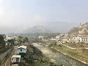
Zokhawthar
Zokhawthar is a village in the Champhai district of Mizoram, India.[1] It is located in the Khawzawl R.D. Block, on the India–Myanmar border, near the Rih Dil lake. On the Myanmar side is Khawmawi village accessible via a bridge built over the Harhva river.
Zokhawthar | |
|---|---|
village | |
 Zokhawdar on the right and Rihkhawdar on the left | |
 Zokhawthar Location in Mizoram, India  Zokhawthar Zokhawthar (India) | |
| Coordinates: 23.3652465°N 93.3855078°E | |
| Country | India |
| State | Mizoram |
| District | Champhai |
| Block | Khawzawl |
| Elevation | 735 m (2,411 ft) |
| Population (2011) | |
| • Total | 2,632 |
| Time zone | UTC+5:30 (IST) |
| 2011 census code | 271338 |
The Zokhawthar land immigration check-post was opened on the Indo-Myanmar border in August 2018 and is one of the two such check-posts in the state of Mizoram.[2]
Demographics
According to the 2011 census of India, Zokhawthar has 501 households. The effective literacy rate (i.e. the literacy rate of population excluding children aged 6 and below) is 93.58%.[3]
| Total | Male | Female | |
|---|---|---|---|
| Population | 2632 | 1299 | 1333 |
| Children aged below 6 years | 498 | 249 | 249 |
| Scheduled caste | 1 | 1 | 0 |
| Scheduled tribe | 2569 | 1260 | 1309 |
| Literates | 1997 | 1006 | 991 |
| Workers (all) | 994 | 642 | 352 |
| Main workers (total) | 848 | 582 | 266 |
| Main workers: Cultivators | 156 | 125 | 31 |
| Main workers: Agricultural labourers | 278 | 205 | 73 |
| Main workers: Household industry workers | 29 | 13 | 16 |
| Main workers: Other | 385 | 239 | 146 |
| Marginal workers (total) | 146 | 60 | 86 |
| Marginal workers: Cultivators | 13 | 8 | 5 |
| Marginal workers: Agricultural labourers | 36 | 22 | 14 |
| Marginal workers: Household industry workers | 19 | 7 | 12 |
| Marginal workers: Others | 78 | 23 | 55 |
| Non-workers | 1638 | 657 | 981 |
References
- "Mizoram villages" (PDF). Land Records Information Systems Division, NIC. Archived from the original (PDF) on 6 August 2014. Retrieved 22 August 2015.
- https://www.business-standard.com/article/pti-stories/land-immigration-centre-along-myanmar-border-opened-118083000881_1.html
- "District Census Handbook - Champhai" (PDF). 2011 Census of India. Directorate of Census Operations, Mizoram. Retrieved 22 August 2015.
This article is issued from Wikipedia. The text is licensed under Creative Commons - Attribution - Sharealike. Additional terms may apply for the media files.