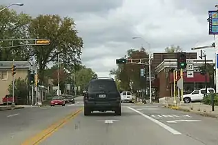
Wisconsin Highway 157
State Trunk Highway 157 (often called Highway 157, STH-157 or WIS 157) is a short state highway in the U.S. state of Wisconsin. It runs east on Main Street from WIS 35 (Second Avenue) in downtown Onalaska to the US Highway 53 (US 53) freeway. There it turns south, running concurrently with US 53 to the Interstate 90 (I-90) interchange. US 53 leaves WIS 157 to head west on I-90, but WIS 157 continues southeast to WIS 16 at the Valley View Mall.
| ||||
|---|---|---|---|---|

WIS 157 highlighted in red | ||||
| Route information | ||||
| Maintained by WisDOT | ||||
| Length | 2.81 mi[1] (4.52 km) | |||
| Major junctions | ||||
| West end | ||||
| East end | ||||
| Location | ||||
| Counties | La Crosse | |||
| Highway system | ||||
| ||||

According to the La Crosse Area Planning Committee's 2030 Metropolitan Area Transit Plan, the route may not remain WIS 157 forever. The plan suggests that following the completion of an extension project on US 53 (planned for 2012-2015), the Main Street portion will become a local street, with the rest becoming part of WIS 53.
Major intersections
The entire highway is in La Crosse County.
| Location | mi[2] | km | Destinations | Notes | |
|---|---|---|---|---|---|
| Onalaska | 0.0 | 0.0 | |||
| 1.1 | 1.8 | Western end of US 53 concurrency | |||
| 1.8 | 2.9 | Eastern end of US 53 concurrency | |||
| La Crosse | 2.6 | 4.2 | |||
1.000 mi = 1.609 km; 1.000 km = 0.621 mi
| |||||
References
- Bessert, Chris. "Wisconsin Highways: Highways 150-159 (Highway 157)". Wisconsin Highways. Retrieved March 20, 2007.
- Google (December 27, 2020). "Overview Map of WIS 157" (Map). Google Maps. Google. Retrieved December 27, 2020.
See also
 U.S. Roads portal
References
External links
 Media related to Wisconsin Highway 157 at Wikimedia Commons
