Whangarata railway station
Whangarata railway station was a station on the North Island Main Trunk, and in the Waikato region of New Zealand. It was originally known as Wangarata.
Whangarata railway station | |
|---|---|
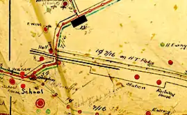
 Map of Whangarata railway station in 1920s | |
| Location | New Zealand |
| Coordinates | 37.260°S 174.987°E |
| Line(s) | North Island Main Trunk |
| Platforms | 2 |
| Tracks | 2 |
| History | |
| Opened | 20 May 1875 |
| Closed | 3 October 1966 |
The station was opened on 20 May 1875, and was closed on 3 October 1966.[1]
Whangarata was a flag station, 37 mi (60 km) south of Auckland.[2] It was on a steep gradient,[3] 618.4 km (384.3 mi) north of Wellington, 3.17 km (1.97 mi) east of Tuakau, 4.28 km (2.66 mi) west of Pokeno and 60 m (200 ft) above sea level.[4]
A deviation in 1914 allowed for an easier curve and gradient.[5]
| Preceding station | Historical railways | Following station | ||
|---|---|---|---|---|
| Tuakau Line open, station closed |
North Island Main Trunk New Zealand Railways Department |
Pokeno Line open, station closed | ||
References
- Scoble, Juliet (2012). Names & Opening & Closing Dates of Railway Stations in New Zealand, 1863 to 2012. Wellington. p. 152.
- "Page 6 Advertisements Column 3 (New Zealand Herald, 1882-03-31)". paperspast.natlib.govt.nz National Library of New Zealand. Retrieved 20 May 2017.
- Representatives, New Zealand Parliament House of (1895). Parliamentary Debates.
- New Zealand Railway and Tramway Atlas (Fourth ed.). Quail Map Co. 1993. ISBN 0-900609-92-3.
- "Improvement to a section of the main trunk railway, with the completion of a new cutting, allowing a straight run with an easier grade at Whangarata". www.aucklandcity.govt.nz. 2 July 1914. Retrieved 15 March 2020.
This article is issued from Wikipedia. The text is licensed under Creative Commons - Attribution - Sharealike. Additional terms may apply for the media files.