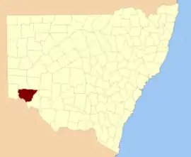
Wentworth County

Wentworth County is one of the 141 Cadastral divisions of New South Wales. The Murray River is the boundary to the south, and the Anabranch of the Darling River is the western boundary. It includes the area where the Darling River joins the Murray River.

Wentworth
New South Wales
Location in New South Wales
Lands administrative divisions around Wentworth:
Windeyer Perry Manara
Tara Wentworth Taila
Millewa (Vic) Karkarooc (Vic) Taila

Wentworth County was named in honour of the explorer and statesman William Charles Wentworth.[1]

Parishes within this county

A full list of parishes found within this county; their current LGA and mapping coordinates to the approximate centre of each location is as follows:

ParishLGACoordinates
AnnandWentworth Shire33°41′35″S 142°53′37″E
ArumpoWentworth Shire33°43′39″S 142°55′25″E
AvocaWentworth Shire33°55′35″S 141°51′59″E
BelarWentworth Shire34°04′28″S 142°14′22″E
BingooWentworth Shire33°45′22″S 141°54′40″E
BrewangWentworth Shire34°02′46″S 142°28′46″E
BullanmongWentworth Shire33°36′37″S 142°56′29″E
BulubulaWentworth Shire33°42′02″S 142°25′26″E
BunneringeeWentworth Shire33°36′46″S 141°46′46″E
BuraguyWentworth Shire33°48′11″S 142°52′09″E
BurrieWentworth Shire33°30′51″S 142°25′55″E
BurtundyWentworth Shire33°48′29″S 142°12′59″E
CliffsWentworth Shire34°09′33″S 142°21′23″E
ConnargeeWentworth Shire33°32′56″S 142°31′52″E
CoonpaWentworth Shire33°37′09″S 142°47′47″E
CoparWentworth Shire33°57′38″S 142°11′43″E
CowlWentworth Shire34°11′44″S 142°35′23″E
CudmoreWentworth Shire33°52′35″S 141°47′15″E
CurnooWentworth Shire33°34′36″S 142°21′04″E
DarlingWentworth Shire33°37′36″S 142°29′10″E
DeanWentworth Shire34°17′06″S 142°26′19″E
EmuWentworth Shire33°53′18″S 142°07′04″E
Gol GolWentworth Shire34°07′27″S 142°13′28″E
GutpyWentworth Shire33°31′29″S 142°08′46″E
IllingerryWentworth Shire33°43′01″S 142°13′24″E
LetheroeWentworth Shire33°34′43″S 142°35′48″E
LissanWentworth Shire33°35′19″S 141°54′03″E
MatongWentworth Shire34°01′24″S 142°21′16″E
MercheWentworth Shire33°49′35″S 142°07′38″E
MernoWentworth Shire33°32′27″S 142°18′11″E
MilkengayWentworth Shire33°28′08″S 141°55′09″E
MillieWentworth Shire34°02′01″S 142°06′34″E
MimiWentworth Shire33°51′09″S 142°25′28″E
MindelwulWentworth Shire33°48′28″S 142°46′48″E
MoangolaWentworth Shire33°39′44″S 142°40′46″E
MoorpaWentworth Shire33°44′28″S 141°46′38″E
MourquongWentworth Shire34°04′36″S 142°05′06″E
MurnowellaWentworth Shire33°47′37″S 142°36′42″E
NangaWentworth Shire33°41′08″S 142°13′14″E
NeilpoWentworth Shire34°05′57″S 141°48′57″E
North CowlWentworth Shire34°08′57″S 142°34′37″E
NundrowerWentworth Shire33°56′31″S 142°38′19″E
OgroWentworth Shire33°48′16″S 142°19′55″E
OportoUnincorporated31°46′41″S 144°52′03″E
PalinyewahWentworth Shire33°53′21″S 142°01′36″E
ParaWentworth Shire33°47′06″S 142°05′21″E
ParingiWentworth Shire34°15′08″S 142°19′15″E
PernolingayWentworth Shire33°37′31″S 141°53′43″E
PoimbaWentworth Shire33°45′35″S 142°32′33″E
PonderyWentworth Shire33°52′55″S 142°41′07″E
PulpaWentworth Shire33°32′30″S 142°41′50″E
RomaWentworth Shire33°39′11″S 142°59′18″E
Salt LakeWentworth Shire33°33′24″S 142°12′38″E
ScottWentworth Shire33°44′50″S 142°19′45″E
SturtWentworth Shire33°42′00″S 142°02′58″E
TapioWentworth Shire33°57′01″S 142°00′27″E
TarangaraWentworth Shire33°39′20″S 142°19′46″E
ThirrangWentworth Shire34°06′01″S 142°39′23″E
ThittoWentworth Shire34°12′32″S 142°26′55″E
ThoombyWentworth Shire33°44′28″S 142°46′40″E
Til TilWentworth Shire33°58′05″S 142°17′04″E
TiltaoWentworth Shire34°01′18″S 141°58′14″E
ToontoraWentworth Shire33°39′17″S 142°00′33″E
TugimaWentworth Shire33°50′12″S 141°54′37″E
TulrigoWentworth Shire33°30′59″S 142°02′06″E
UkiWentworth Shire33°59′46″S 142°33′10″E
UlongWentworth Shire33°56′59″S 142°44′12″E
WamberaWentworth Shire33°54′54″S 142°22′55″E
WentworthWentworth Shire34°05′50″S 141°56′33″E
WinnegowWentworth Shire33°59′14″S 142°27′48″E
YertaWentworth Shire33°36′06″S 142°06′43″E

References

  1. "Wentworth". Geographical Names Register (GNR) of NSW. Geographical Names Board of New South Wales. Retrieved 11 August 2013.
This article is issued from Wikipedia. The text is licensed under Creative Commons - Attribution - Sharealike. Additional terms may apply for the media files.