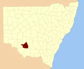
Waradgery County

Waradgery County is one of the 141 Cadastral divisions of New South Wales. It contains the town of Hay. It includes the area between the Lachlan River and the Murrumbidgee River where they meet. The Lachlan River is the northern boundary of the county, and the Murrumbidgee for a small section is the southern boundary, but the county also includes some of the land to the south of the Murrumbidgee near Hay.

Waradgery
New South Wales
Location in New South Wales
Lands administrative divisions around Waradgery:
Caira Waljeers Nicholson
Caira Waradgery Sturt
Wakool Townsend Boyd

The name Waradgery is believed to be derived from a local Aboriginal word (probably in relation to the Wiradjuri people.[1]

Parishes within this county

Wajadgery County NSW as shown on John Sands' 1886 map[2]

A full list of parishes found within this county; their current LGA and mapping coordinates to the approximate centre of each location is as follows:

ParishLGACoordinates
AbercrombieHay Shire Council34°38′54″S 144°41′04″E
BeabulaHay Shire Council34°29′54″S 145°10′04″E
BedarbidgalHay Shire Council34°47′54″S 145°08′04″E
Benduck NorthHay Shire Council34°25′54″S 144°35′04″E
Benduck SouthHay Shire Council34°30′54″S 144°36′04″E
BeresfordHay Shire Council34°44′54″S 144°47′04″E
BoyongHay Shire Council34°20′54″S 144°02′04″E
BrushHay Shire Council34°36′54″S 145°00′04″E
BudgeeHay Shire Council34°21′54″S 144°19′04″E
BurrabogieHay Shire Council34°33′54″S 145°11′04″E
ChambersHay Shire Council34°47′54″S 144°00′04″E
ClunyHay Shire Council34°20′54″S 144°36′04″E
CoonoonHay Shire Council34°29′54″S 144°30′04″E
CubaHay Shire Council34°47′54″S 144°55′04″E
DarcoolaHay Shire Council34°21′54″S 144°28′04″E
DowlingHay Shire Council34°13′54″S 144°24′04″E
East WaradgeryHay Shire Council34°29′54″S 144°54′04″E
Eli ElwahHay Shire Council34°32′54″S 144°58′04″E
EurolieHay Shire Council34°44′54″S 145°09′04″E
GelamHay Shire Council34°21′54″S 144°11′04″E
GodfreyHay Shire Council34°44′54″S 144°34′04″E
GrantHay Shire Council34°14′54″S 145°06′04″E
Gre GreHay Shire Council34°37′54″S 144°30′04″E
Hay SouthHay Shire Council34°32′54″S 144°52′04″E
HayHay Shire Council34°29′54″S 144°50′04″E
HiawathaHay Shire Council34°11′54″S 144°49′04″E
IlginbahHay Shire Council34°39′54″S 145°10′04″E
IllilawaHay Shire Council34°20′54″S 145°00′04″E
InaHay Shire Council34°13′54″S 145°00′04″E
JellalabadHay Shire Council34°27′54″S 144°23′04″E
JumbuckHay Shire Council34°02′54″S 144°47′04″E
KillendooHay Shire Council34°44′54″S 145°04′04″E
LangHay Shire Council34°34′54″S 144°42′04″E
LaraHay Shire Council34°12′54″S 144°48′04″E
LeuraHay Shire Council34°13′54″S 144°42′04″E
LorraineHay Shire Council34°19′54″S 144°50′04″E
MagnoliaHay Shire Council34°43′54″S 144°17′04″E
MaudeHay Shire Council34°26′54″S 144°19′04″E
MelroseHay Shire Council34°44′54″S 144°40′04″E
MidgecleughHay Shire Council34°47′54″S 144°40′04″E
MingahHay Shire Council34°07′54″S 145°03′04″E
MungadalHay Shire Council34°32′54″S 144°47′04″E
NarrawidgeryHay Shire Council34°38′54″S 144°52′04″E
NerangHay Shire Council34°34′54″S 144°25′04″E
OxleyHay Shire Council34°12′54″S 144°07′04″E
PalmerHay Shire Council34°23′54″S 144°24′04″E
Paradise EastHay Shire Council34°47′54″S 144°49′04″E
ParadiseHay Shire Council34°47′54″S 144°45′04″E
PattersonHay Shire Council34°09′54″S 144°36′04″E
PembelgongHay Shire Council34°31′54″S 145°07′04″E
PevenseyHay Shire Council34°35′54″S 144°35′04″E
PimpampaHay Shire Council34°24′54″S 144°14′04″E
QuandongHay Shire Council34°07′54″S 144°44′04″E
RankinHay Shire Council34°44′54″S 144°53′04″E
RussellHay Shire Council34°43′54″S 144°27′04″E
RutherfordHay Shire Council34°25′54″S 145°03′04″E
SimsonHay Shire Council34°00′54″S 144°50′04″E
SinclairHay Shire Council34°39′54″S 144°17′04″E
Thellangering WestHay Shire Council34°13′54″S 144°20′04″E
ThellangeringHay Shire Council34°12′54″S 144°31′04″E
TindaleHay Shire Council34°38′54″S 144°56′04″E
TongulHay Shire Council34°29′54″S 144°41′04″E
ToogimbieHay Shire Council34°34′54″S 144°30′04″E
ToopuntulHay Shire Council34°20′54″S 144°06′04″E
TullyHay Shire Council34°19′54″S 145°07′04″E
TwynamHay Shire Council34°37′54″S 144°46′04″E
UlongaHay Shire Council34°09′54″S 144°40′04″E
WahwoonHay Shire Council34°32′54″S 145°00′04″E
WallabyHay Shire Council34°03′54″S 144°54′04″E
WandigongHay Shire Council34°39′54″S 144°34′04″E
WaradgeryHay Shire Council34°24′54″S 143°50′04″E
WarrigalHay Shire Council34°11′54″S 145°03′04″E
WaymeaHay Shire Council34°26′54″S 144°28′04″E
West WaradgeryHay Shire Council34°29′54″S 144°46′04″E
WilgahHay Shire Council34°36′54″S 145°05′04″E
WillisHay Shire Council34°43′54″S 144°22′04″E
WingenHay Shire Council34°40′54″S 144°22′04″E
WirkenberjalHay Shire Council34°47′54″S 145°00′04″E
WooloombyeHay Shire Council34°12′54″S 144°36′04″E
WooloondoolHay Shire Council34°22′54″S 144°43′04″E
WyomingHay Shire Council34°07′54″S 144°52′04″E
Yang YangHay Shire Council34°16′54″S 144°29′04″E
YimbaringHay Shire Council34°13′54″S 144°15′04″E

References

  1. "Waradgery". Geographical Names Register (GNR) of NSW. Geographical Names Board of New South Wales. Retrieved 11 August 2013.
  2. The New atlas of Australia (John Sands 1886) map 21.
This article is issued from Wikipedia. The text is licensed under Creative Commons - Attribution - Sharealike. Additional terms may apply for the media files.