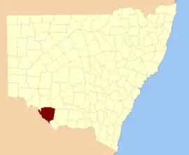
Wakool County

Wakool County is one of the 141 Cadastral divisions of New South Wales. It contains the town of Wakool.

Wakool
New South Wales
Location in New South Wales
Lands administrative divisions around Wakool:
Caira Caira Waradgery
Tatchera (Vic) Wakool Townsend
Tatchera (Vic) Gunbower (Vic) Cadell

The name Wakool is believed to be derived from a local Aboriginal word.[1]

Parishes within this county

A full list of parishes found within this county; their current LGA and mapping coordinates to the approximate centre of each location is as follows:

ParishLGACoordinates
BaldonEdward River Council34°55′54″S 144°09′04″E
BalpoolCouncil of the Shire of Wakool35°13′54″S 144°22′04″E
BarhamCouncil of the Shire of Wakool35°36′54″S 144°09′04″E
BarrabuCouncil of the Shire of Wakool35°11′54″S 144°16′04″E
BelmoreCouncil of the Shire of Wakool35°24′54″S 144°00′04″E
BenjeeCouncil of the Shire of Wakool35°03′54″S 144°08′04″E
BerambongCouncil of the Shire of Wakool35°01′54″S 143°57′04″E
BeremegadCouncil of the Shire of Wakool35°25′54″S 144°09′04″E
BinbinetteCouncil of the Shire of Wakool34°59′54″S 143°53′04″E
BookitCouncil of the Shire of Wakool35°29′54″S 144°19′04″E
BoydCouncil of the Shire of Wakool35°13′54″S 144°05′04″E
BundyulumblahEdward River Council35°01′54″S 144°31′04″E
BungunyahCouncil of the Shire of Wakool35°09′54″S 143°25′04″E
BurbagadahCouncil of the Shire of Wakool35°07′54″S 144°08′04″E
BurrawangCouncil of the Shire of Wakool34°59′54″S 143°39′04″E
BymueCouncil of the Shire of Wakool35°05′54″S 143°24′04″E
CanganCouncil of the Shire of Wakool35°41′54″S 144°18′04″E
CaroonboonEdward River Council34°55′54″S 144°20′04″E
ChowarCouncil of the Shire of Wakool35°20′54″S 144°21′04″E
CobwellCouncil of the Shire of Wakool35°29′54″S 144°07′04″E
CockranCouncil of the Shire of Wakool35°21′54″S 144°27′04″E
ColvinCouncil of the Shire of Wakool35°02′54″S 144°19′04″E
CondoulpeCouncil of the Shire of Wakool34°49′54″S 143°38′04″E
CooboolCouncil of the Shire of Wakool35°10′54″S 143°45′04″E
CoonamitCouncil of the Shire of Wakool35°10′54″S 143°39′04″E
CootniteEdward River Council35°10′54″S 144°31′04″E
CorryCouncil of the Shire of Wakool35°29′54″S 144°23′04″E
CunninyeukCouncil of the Shire of Wakool35°16′54″S 143°54′04″E
CurrpoolCouncil of the Shire of Wakool35°15′54″S 143°38′04″E
DanberryCouncil of the Shire of Wakool35°35′54″S 144°15′04″E
DarlotCouncil of the Shire of Wakool35°00′54″S 144°25′04″E
FirebraceEdward River Council34°55′54″S 144°30′04″E
GenoeCouncil of the Shire of Wakool35°03′54″S 143°30′04″E
GerabbitCouncil of the Shire of Wakool35°06′54″S 144°18′04″E
GnuieCouncil of the Shire of Wakool35°26′54″S 143°54′04″E
GonnCouncil of the Shire of Wakool35°29′54″S 144°00′04″E
GwynneEdward River Council34°51′54″S 144°11′04″E
GynongCouncil of the Shire of Wakool35°20′54″S 144°16′04″E
HindmarshCouncil of the Shire of Wakool35°05′54″S 144°02′04″E
JimaringleCouncil of the Shire of Wakool35°19′54″S 144°11′04″E
KerkeriCouncil of the Shire of Wakool34°48′54″S 143°56′04″E
KirrabirriEdward River Council35°06′54″S 144°31′04″E
KyaliteCouncil of the Shire of Wakool34°55′54″S 143°33′04″E
LandaleCouncil of the Shire of Wakool35°02′54″S 144°00′04″E
LiewaCouncil of the Shire of Wakool34°59′54″S 143°30′04″E
LintotCouncil of the Shire of Wakool34°49′54″S 143°44′04″E
LyleCouncil of the Shire of Wakool34°59′54″S 144°00′04″E
MallanCouncil of the Shire of Wakool35°03′54″S 143°45′04″E
MalleeCouncil of the Shire of Wakool34°54′54″S 143°23′04″E
MeinCouncil of the Shire of Wakool34°54′54″S 143°57′04″E
MelloolCouncil of the Shire of Wakool35°23′54″S 143°49′04″E
MerranCouncil of the Shire of Wakool35°15′54″S 143°44′04″E
MerwinCouncil of the Shire of Wakool34°48′54″S 143°50′04″E
Mia MiaCouncil of the Shire of Wakool35°33′54″S 144°17′04″E
MilleuCouncil of the Shire of Wakool34°57′54″S 143°22′04″E
MirandaEdward River Council34°51′54″S 144°30′04″E
MoolpaCouncil of the Shire of Wakool34°59′54″S 143°34′04″E
MoorongattaCouncil of the Shire of Wakool35°22′54″S 143°54′04″E
Moulamein SouthCouncil of the Shire of Wakool35°09′54″S 144°02′04″E
MoulameinCouncil of the Shire of Wakool35°02′54″S 144°03′04″E
MurgaCouncil of the Shire of Wakool35°10′54″S 144°24′04″E
NearroongarooCouncil of the Shire of Wakool35°16′54″S 144°00′04″E
NiemurCouncil of the Shire of Wakool35°04′54″S 143°51′04″E
NoorongCouncil of the Shire of Wakool35°20′54″S 143°58′04″E
NullumCouncil of the Shire of Wakool35°07′54″S 144°20′04″E
NunnagoytCouncil of the Shire of Wakool35°31′54″S 144°05′04″E
NyangCouncil of the Shire of Wakool35°10′54″S 144°11′04″E
ParquinCouncil of the Shire of Wakool35°00′54″S 144°03′04″E
PerekertenCouncil of the Shire of Wakool34°54′54″S 143°51′04″E
PevenseyEdward River Council34°49′54″S 144°19′04″E
Poon BoonCouncil of the Shire of Wakool35°05′54″S 143°34′04″E
PuahCouncil of the Shire of Wakool35°09′54″S 143°30′04″E
RaubelleEdward River Council34°55′54″S 144°16′04″E
SalisburyCouncil of the Shire of Wakool34°53′54″S 143°45′04″E
SpeewaCouncil of the Shire of Wakool35°09′54″S 143°34′04″E
TcheleryEdward River Council34°44′54″S 144°09′04″E
ThalakaEdward River Council34°51′54″S 144°18′04″E
TittilCouncil of the Shire of Wakool35°39′54″S 144°14′04″E
TooleybucCouncil of the Shire of Wakool35°01′54″S 143°24′04″E
ToolmahCouncil of the Shire of Wakool35°18′54″S 143°50′04″E
ToolonCouncil of the Shire of Wakool35°29′54″S 144°14′04″E
TowwerukCouncil of the Shire of Wakool35°14′54″S 143°54′04″E
TuroraCouncil of the Shire of Wakool34°50′54″S 143°33′04″E
WakoolCouncil of the Shire of Wakool34°58′54″S 143°27′04″E
WandaradgetCouncil of the Shire of Wakool35°17′54″S 144°05′04″E
WetuppaCouncil of the Shire of Wakool35°14′54″S 143°51′04″E
WhymoulCouncil of the Shire of Wakool35°32′54″S 144°11′04″E
WillakoolCouncil of the Shire of Wakool35°20′54″S 143°43′04″E
WindouranCouncil of the Shire of Wakool35°02′54″S 144°14′04″E
WinterCouncil of the Shire of Wakool34°51′54″S 143°59′04″E
WoodCouncil of the Shire of Wakool34°54′54″S 144°03′04″E
WooroomaCouncil of the Shire of Wakool35°05′54″S 144°12′04″E
WorobyanCouncil of the Shire of Wakool35°06′54″S 143°56′04″E
YadabalCouncil of the Shire of Wakool35°16′54″S 144°27′04″E
YadchowCouncil of the Shire of Wakool35°04′54″S 143°41′04″E
YangaCouncil of the Shire of Wakool34°44′54″S 144°08′04″E
YarreinCouncil of the Shire of Wakool35°01′54″S 143°37′04″E
YellymongCouncil of the Shire of Wakool35°18′54″S 143°37′04″E

References

  1. "Wakool". Geographical Names Register (GNR) of NSW. Geographical Names Board of New South Wales. Retrieved 11 August 2013.
This article is issued from Wikipedia. The text is licensed under Creative Commons - Attribution - Sharealike. Additional terms may apply for the media files.