Waione Siding railway station
Waione Siding was very briefly a stop on the North Island Main Trunk line, in the Ruapehu District of New Zealand in the Ōngarue valley.[1] It was also known as Ninia.[2]
Waione Siding railway station | |||||||||||
|---|---|---|---|---|---|---|---|---|---|---|---|
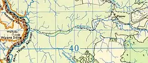
 Waione on 1956 edition of one inch map sheet N92 | |||||||||||
| Location | New Zealand | ||||||||||
| Coordinates | 38.656300°S 175.315900°E | ||||||||||
| Elevation | 203 m (666 ft) | ||||||||||
| Line(s) | North Island Main Trunk | ||||||||||
| Distance | Wellington 426.86 km (265.24 mi) | ||||||||||
| History | |||||||||||
| Opened | 1 April 1917 | ||||||||||
| Closed | passenger 1 February 1918 goods 3 October 1948 | ||||||||||
| Electrified | June 1988 | ||||||||||
| Services | |||||||||||
| |||||||||||
It served a Marton Sash & Door Company tramway[3] and was also a stop for occasional excursion trains.[4][5] From 1928 the tramway was operated by a Price 16-wheeler steam locomotive.[3] In 1927 a shelter shed was built. It was damaged by fire in 1950. In 1929 the siding became a tablet station, at a cost of about £4430.[2]
The siding served a small settlement, where 23 people voted in 1928[6] and 22 in 1935.[7] In 2013 meshblock 1042000, which includes the area west of the railway, had a population of 30 in 6 houses.[8]
References
- Scoble, Juliet. "Names & Opening & Closing Dates of Railway Stations in New Zealand 1863 to 2010" (PDF). Rail Heritage Trust of New Zealand.
- "Stations" (PDF). NZR Rolling Stock Lists. Retrieved 2020-08-10.
- "Price 16-wheeler steam locomotive". National Library of New Zealand. 1916. Retrieved 2020-04-01.
- "Page 1 Advertisements Column 6 KING COUNTRY CHRONICLE". paperspast.natlib.govt.nz. 5 Feb 1927. Retrieved 2020-04-01.
- "Page 1 Advertisements Column 5 KING COUNTRY CHRONICLE". paperspast.natlib.govt.nz. 2 Feb 1935. Retrieved 2020-04-01.
- "THE CONTEST IN RAGLAN. WAIPA POST". paperspast.natlib.govt.nz. 15 Nov 1928. Retrieved 2020-04-01.
- "WAITOMO ELECTORATE WAIPA POST". paperspast.natlib.govt.nz. 29 Nov 1935. Retrieved 2020-04-01.
- "2013 Census map – QuickStats about a place". archive.stats.govt.nz. Retrieved 2020-04-01.
This article is issued from Wikipedia. The text is licensed under Creative Commons - Attribution - Sharealike. Additional terms may apply for the media files.