Vogelkop-Aru lowland rain forests
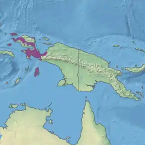
The Vogelkop-Aru lowland rain forests is a tropical moist forest ecoregion in Indonesia. The ecoregion covers the peninsular lowlands of western New Guinea, along with the Aru Islands and other nearby islands.
| Vogelkop-Aru lowland rain forests | |
|---|---|
.jpg.webp) Wayag Islands | |
 Ecoregion territory (in purple) | |
| Ecology | |
| Realm | Australasian realm |
| Biome | tropical and subtropical moist broadleaf forests |
| Borders | |
| Geography | |
| Area | 75,270 km2 (29,060 sq mi) |
| Countries | Indonesia |
| Province | Maluku, Papua, and West Papua |
| Conservation | |
| Conservation status | Relatively stable/intact |
| Protected | 7,557 km² (10%)[1] |
Geography
The ecoregion includes the lowland and hill (below 1000 meters elevation) forests of the Bird's Head Peninsula (also known as the Vogelkop Peninsula), Bomberai Peninsula, and the Bird's Neck Isthmus, as well as the Aru Islands to the south and Raja Ampat Islands (Misool, Salawati, Waigeo, Kofiau, and others) to the west.
The Aru and Raja Ampat islands sit on the Australia-New Guinea continental shelf. When sea levels were lower during the ice ages, these islands were joined to the Australia-New Guinea continent, which allowed terrestrial plants and animals to move between them.
The peninsular mountains above 1000 meters elevation, including the Arfak Mountains and Tamrau Mountains, constitute the separate and distinct Vogelkop montane rain forests ecoregion.[2]
Climate
The ecoregion has a tropical rain forest climate.
Flora
The vegetation of the ecoregion is tropical wet evergreen forest, including lowland alluvial forests, hill forests, and limestone forests.[3]
Fauna
The ecoregion has 47 species of mammals, including marsupials, murid rodents, and bats. There are no strictly endemic mammal species, but several species are threatened or have a limited range.[4]
The ecoregion has 366 species of birds, of which nine are endemic.[5] It encompasses the West Papuan lowlands and Aru Islands endemic bird areas.[6] The largest bird in the ecoregion is the flightless southern cassowary (Casuarius casuarius).[7]
Protected areas
A 2017 assessment found that 7,557 km², or 10%, of the ecoregion is in protected areas. About 70% of the unprotected area is still forested.[8]
External links
- "Vogelkop-Aru lowland rain forests". Terrestrial Ecoregions. World Wildlife Fund.
- West Papuan lowlands endemic bird area (BirdLife International)
- Aru Islands endemic bird area (BirdLife International)
References
- Eric Dinerstein, David Olson, et al. (2017). An Ecoregion-Based Approach to Protecting Half the Terrestrial Realm, BioScience, Volume 67, Issue 6, June 2017, Pages 534–545; Supplemental material 2 table S1b.
- Wikramanayake, Eric; Eric Dinerstein; Colby J. Loucks; et al. (2002). Terrestrial Ecoregions of the Indo-Pacific: a Conservation Assessment. Washington, DC: Island Press.
- Wikramanayake, Eric; Eric Dinerstein; Colby J. Loucks; et al. (2002). Terrestrial Ecoregions of the Indo-Pacific: a Conservation Assessment. Washington, DC: Island Press.
- "Vogelkop-Aru lowland rain forests". Terrestrial Ecoregions. World Wildlife Fund.
- "Vogelkop-Aru lowland rain forests". Terrestrial Ecoregions. World Wildlife Fund.
- BirdLife International (2020) Endemic Bird Areas factsheet: West Papuan lowlands. Accessed from http://www.birdlife.org on 04/06/2020.
- BirdLife International. 2018. Casuarius casuarius. The IUCN Red List of Threatened Species 2018: e.T22678108A131902050. https://dx.doi.org/10.2305/IUCN.UK.2018-2.RLTS.T22678108A131902050.en. Downloaded on 09 June 2020.
- Eric Dinerstein, David Olson, et al. (2017). An Ecoregion-Based Approach to Protecting Half the Terrestrial Realm, BioScience, Volume 67, Issue 6, June 2017, Pages 534–545; Supplemental material 2 table S1b.