Texas State Highway Spur 148
State Highway Spur 148 (Spur 148) is a state highway spur route near Fort Hancock in Hudspeth County, Texas.[1]
| ||||
|---|---|---|---|---|
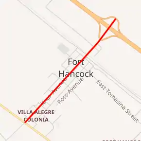
Spur 148 highlighted in red | ||||
| Route information | ||||
| Maintained by TxDOT | ||||
| Length | 1.440 mi[1] (2.317 km) | |||
| Existed | 1944–present | |||
| Major junctions | ||||
| West end | ||||
| East end | ||||
| Location | ||||
| Counties | Hudspeth | |||
| Highway system | ||||
| ||||

Route description
Spur 148 begins at SH 20, travels northeastward through Fort Hancock as Knox Ave., and ends at exit 72 of I-10.[2]
History
Spur 148 was assigned on February 11, 1944 to the "Fort Hancock Spur," running northward from US 80 (present-day SH 20) to Fort Hancock. On September 26, 1963, Spur 148 was extended northward by 0.4 miles to I-10.[1]
Major intersections
The entire route is in Hudspeth County.
| Location | mi[1] | km | Destinations | Notes | |
|---|---|---|---|---|---|
| Fort Hancock | 0.000 | 0.000 | |||
| | 1.440 | 2.317 | Exit 72 (I-10) | ||
| 1.000 mi = 1.609 km; 1.000 km = 0.621 mi | |||||
See also
 U.S. Roads portal
 Texas portal
References
- Transportation Planning and Programming Division (n.d.). "State Highway Spur No. 148". Highway Designation Files. Texas Department of Transportation. Retrieved 2011-09-22.
- Transportation Planning and Programming Division (2012). Texas County Mapbook (PDF) (Map) (2012 ed.). 1:120,000. Texas Department of Transportation. p. 76. OCLC 867856197. Retrieved 2011-09-22.
External links
![]() Geographic data related to Texas State Highway Spur 148 at OpenStreetMap
Geographic data related to Texas State Highway Spur 148 at OpenStreetMap
This article is issued from Wikipedia. The text is licensed under Creative Commons - Attribution - Sharealike. Additional terms may apply for the media files.