Sydney Harbour (Nova Scotia)
Sydney Harbour[1] is the 10-mile long Y-shaped inlet of the Atlantic, oriented southwest-northeast on the northeast shore of Cape Breton Island, Nova Scotia, Canada. At its upper reaches, the harbour forks to form 2 arms, the Northwest Arm and the South Arm. The South Arm is fed upstream by the Sydney River.
| Sydney Harbour | |
|---|---|
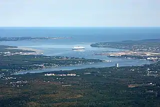
 Sydney Harbour aerial view looking towards the north-east. The RMS Queen Mary 2 lies in the harbour. | |
 Sydney Harbour Sydney Harbour in Nova Scotia | |
| Location | Cape Breton Island, Nova Scotia |
| Coordinates | 46°13′12″N 60°12′20″W |
| Type | Bay |
| Part of | Spanish Bay |
| River sources | Sydney River |
| Ocean/sea sources | Gulf of Saint Lawrence, Atlantic ocean |
| Basin countries | Canada |
| Settlements | Cape Breton Regional Municipality
From west to east: |
| Website | www.sydneyport.ca |
| References | Geographical Names of Canada - Sydney Harbour |
Sydney harbour is the maritime hub for the Cape Breton Regional Municipality. The South Arm affords year-round ice-free deep-water anchorage for large ships, including cruise ships.[2]
The Harbour underwent major dredging in 2011, clearing the channel to 17-meter depth and making it accessible to large container ships.[3][4] Five port facilities currently operate on the shores of Sydney Harbour: the International Coal Pier, Nova Scotia Lands, Sydney Marine Terminal, Sydport Industrial Park (Edwardsville) and Marine Atlantic (North Sydney). The sixth, the new container terminal, NOVAPORTE™ Mega-Terminal, is being planned for Edwardsville.[5][6]
References
- "Geographical Names of Canada - Sydney Harbour". Retrieved 5 June 2018.
- "Cruise". Retrieved 5 June 2018.
- "Dredging commences..."
- "Sydney harbour dredge complete", Cape Breton Post, Sydney, NS, Jan 19, 2012
- NOVAPORTE™
- King, Nancy (February 13, 2018), "Proposed Sydney container terminal still moving forward", Cape Breton Post, Sydney, NS
- Notes
- Nautical chart #4266 SYDNEY HARBOUR, published by Canadian Hydrographic Service, 28 February 2014