Sveifluháls
Sveifluháls is a mafic hyaloclastite ridge of 397 m height in the southwest of Iceland in Gullbringusýsla (Reykjanes Peninsula).[2] It is part of Krýsuvík volcanic system and of the protected area Reykjanes Fólkvangur.[3]
| Sveifluháls | |
|---|---|
| Austurháls | |
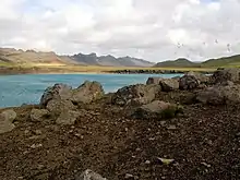
.jpg.webp) Sveifluháls to the left, lake Kleifarvatn in the center, Vatnshlíðarfjall in the far background | |
| Highest point | |
| Elevation | 397 m (1,302 ft) [1] |
| Coordinates | 63°52′03″N 22°05′22″W Jarðvísindi. Háskóli Íslands: Merkjalýsingar. Retrieved 26 August 2020.</ref> |
| Geography | |
 Sveifluháls Iceland | |
| Location | Reykjanes Peninsula, Iceland |
| Geology | |
| Mountain type | hyaloclastite ridge, tindar complex |
| Volcanic arc/belt | Reykjanes Volcanic Belt |
| Last eruption | Pleistocene |
.jpg.webp)

Geography
The mountain is situated between lake Kleifarvatn and the valley Móhálsadalur. In some parts of the ridge, there are geothermal areas, esp. at Krýsuvík and Seltún.[4] It is located at about 5 km from the southern coast of Reykjanes Peninsula.[5]
The ridge actually consists of two parallel narrow ridge segments with a 0,5 km wide valley in between.[5]
Sveifluháls is also called Austurháls in contrast to its parallel ridge on the other side of Móhálsadalur, the Núpshlídarháls ridge, which is also called Vesturháls.[6]
Road 42 passes by directly at the foot of the mountain between the same and lake Kleifarvatn.[7]
Geology
Sveifluháls is a basaltic[5]hyaloclastite ridge, actually a “ca. 22 km long tindar complex".[8] It consists as is usual for such subglacially formed volcanoes, of pillow lavas under a layer of phreatomagmatic tephra (hyaloclastite). Pedersen and her coworkers think that the Ice Age glacier which was covering it at time of formation had a thickness between 70 and 400 m.[8]
Formation of Sveifluháls
Mercurio postulates that the ridge formation started with eruptions under a 450 – 600 m thick ice sheet between 42.000 – 12,400 years BP. The melting of glacier ice induced the formation of one or more subglacial meltwater lakes. Dropping overburden pressures lead to the eruption of vitric phreatomagmatic tuff. Over time this tuff accumulated and formed circular tuff cones, elongated tuff cones and ridges, volcanic edifices that were arranged “along 60 semi-parallel individual linear segments” (i.e. eruption fissures - in this case subglacial ones) “that vary in length between 0,25 and 1,5 km.” [5]
In the following time, these edifices grew and developed further by subaqueous density currents and resuspense resp. settling of the tuff within the meltwater lakes. This was facilitated by over steepening or retreat of the ice walls around the growing volcano. Igneous intrusions into the piles of tuff also helped destabilizing them.[5]
The tuff cones and ridges grew and merged, but they also enclosed a source of jökulhlaup in between them, inter-ridge meltwater catchments with volumes of up to 15 000 000 m3. In the whole, the eruptions of Sveifluháls may have produced 17.25 km3 of meltwater and a DRE of 2,0 km3. In the end, the meltwater lakes drained and at least one of the eruption centers produced subaerial lava,[5] which means that there is a tuya component in the ridge, not all of it was produced by subglacial eruptions.
The eruption in the whole was probably similar to the Gjálp eruption within the Grímsvötn Volcanic System in 1996.[5]
Geothermal activity at Sveifluháls
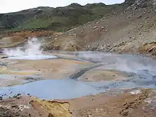
Especially in two areas, geothermal activity at Sveifluháls is intense and connected to Krysuvík volcanic system. These are Seltún on the one hand, and the hills behind the farm and school of Krýsuvík on the other hand (so called Hveradalir). Hot ground, fumaroles, hot springs and mud pots are to be found there. Measurements in Seltún even show a thermal output of about 4 MW. Hydrothermal alteration and this heat lead to precipitation of minerals like hematite, goethite and different sulfur compounds.[4]
Hiking
Many hiking trails lead up on Sveifluháls or are to be found in the vicinity. For example, there are trails up from Seltún at the southern end of the ridge to Arnarvatn and from there into the Móhálsadalur, or for hiking a round to Hetta, one of the southernmost summits of the long Sveifluháls ridge.[9]
There is also the possibility to hike from Vatnsskarð (Reykjanes) up on Sveifluháls and follow the ridge to the highest summit Stapatindur.[10]
See also
| Wikimedia Commons has media related to Sveifluháls. |
External links
General information
- http://icelandicvolcanos.is/?volcano=KRI Krýsuvík. Catalogue of Icelandic Volcanoes.
- https://volcano.si.edu/volcano.cfm?vn=371030 Krýsuvík. Global Volcanism Program. Smithsonian Institution.
Volcano monitoring
References
- Ari Trausti Guðmundsson, Pétur Þorsteinsson: Íslensk fjöll. Gönguleiðir á 152 tind. Reykjavík 2004, p. 256
- Íslandshandbókin. Náttúra, saga og sérkenni. Reykjavík 1989, p. 62
- Reykjanes Fólkvang. Visit Reykjanes. Official Website. (in Icelandic) Retrieved 26 August 2020.
- Lucía Magali Ramírez-González et al.: Remote sensing of surface Hydrothermal Alteration, identification of Minerals and Thermal anomalies at Sveifluháls-Krýsuvík high temperature Geothermal field, SW Iceland. 2019 IOP Conf. Ser.: Earth Environ. Sci. 254 012005 Retrieved 25 August 2020.
- Emily Constantine Mercurio: Processes, Products and Depositional Environments of Ice-Confined Basaltic Fissure Eruptions: A Case Study of the Sveifluháls Volcanic Complex, SW Iceland. University of Pittsburgh. (2011) Retrieved 26 August 2020.
- Reynir Ingibjartsson: 25 Gönguleiðir á Reykjanesskaga. Náttúrann við Bæjarveggin. Reykjavík , p. 82
- Ísland Vegaatlas. Ferðakort. Reykjavík 2006, p. 1
- G.B.M.Pedersen, P. Grosse: Morphometry of subaerial shield volcanoes and glaciovolcanoes from Reykjanes Peninsula, Iceland: Effects of eruption environment. Journal of Volcanology and Geothermal Research 282, (2014), 115-133.
- Reynir Ingibjartsson: 25 Gönguleiðir á Reykjanesskaga. Náttúrann við Bæjarveggin. Reykjavík , p. 100 – 105
- Ari Trausti Guðmundsson, Pétur Þorsteinsson: Íslensk fjöll. Gönguleiðir á 152 tind. Reykjavík 2004, p. 266-267
