Spango Valley
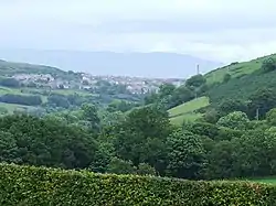
Spango Valley is a steep sided valley to the south-west of Greenock, Scotland. It runs approximately south west to north east for around 1.5 miles (2.4 km) from the confluence of the Spango Burn and Kip Water near Dunrod Farm, to Ravenscraig at the present day Aileymill Gardens. A small stream known as the Spango Burn, runs along the valley floor. The originally meandering burn [1] has been channelised and straightened for much of its length as it runs south west through the valley.
| Spango Valley | |
|---|---|
 Spango Valley from Langhill | |
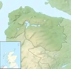
 Spango Valley Location within Inverclyde | |
| OS grid reference | NS 2332 7441 |
| Council area | |
| Lieutenancy area | |
| Country | Scotland |
| Sovereign state | United Kingdom |
| Post town | GREENOCK |
| Postcode district | PA16 |
| Dialling code | 01475 |
| UK Parliament | |
| Scottish Parliament | |
The IBM Years
IBM opened a factory in the valley in 1954 to manufacture typewriters and other office equipment. The factory expanded along the valley floor through the 60s, 70s, 80s and 90s, extending to 1 mile (1.6 km) in length at its peak as the business moved from typewriters to bank terminals and eventually to Personal Computers in the early 1980s. The 1954 factory was built on the site of Kingston Farm, the final building to be constructed by IBM was a call centre, on the site of Spango Farm, which was demolished to make way for it.[2] Remaining farms in the valley are Dunrod, Chrisswell, Flatterton and Leitchland.
By 2009, the IBM factory was partially demolished as parts of the PC manufacturing business were sold to other companies.[3][4] Around this time, the site and remaining buildings were sold by IBM and rebranded as Valley Park, from whom IBM leased some of the buildings that they still occupied.[5] An other occupant on the site at that time was the National Microelectronics Institute.[6] IBM completely vacated the site in October 2016 and moved to the east end of Greenock.[7]
By September 2020, all buildings on the former IBM campus had been demolished[8]
IBM Gallery
 Spango Valley: view of IBM railway station and the "Hole of Spango" from Ailleymill Road
 Buildings at the south end of the IBM campus
 IBM buildings in 2009
 Sanmina SCI branding on the former IBM Automated Materials Distribution Centre building
 IBM Reception in 2008
 IBM Automated Materials Distribution Centre building
 IBM buildings in 2008
 IBM main access road in 2007
 IBM call centre building in 2009
 A plastic building which housed a lab to test computer products for electrical emissions
 This 2013 photo shows that much of the factory has been demolished
 This 2013 photo shows that much of the factory has been demolished
Inverkip Road
In the early 1980s the A742 Inverkip Road through Spango Valley was substantially upgraded to dual carriageway standard to accommodate the increased traffic to and from the IBM complex and the nearby Inverkip Power Station which has also since been demolished.[9] At that time, the road was renumbered to A78 and became a trunk road. The former A78 road (through Gourock) was renumbered to A770 at the same time.[10]
Inverkip Road Gallery
 The "IBM flyover" which provided access to the IBM campus from the A78
 New road signs on the approach to the (by now mostly derelict) IBM campus
 Pedestrians crossing warning signs on the approach to the IBM campus
 Warning sign at the pedestrian crossing point at the IBM campus
Railway
The Greenock and Wemyss Bay Railway Company opened a line from Port Glasgow, through Spango Valley to Wemyss Bay in 1865. Ravenscraig station was a single platform station, located at the extreme north end of the valley, which was in use from 1865 to 1944.
Now part of the electrified Inverclyde railway line between Glasgow Central and Wemyss Bay, the single track line passes along the east side of the valley (between Branchton and Inverkip stations). IBM railway station, which opened in May 1978 as IBM Halt to serve the IBM factory had its services suspended on 8 December 2018 following demolition of the IBM factory.[11]
A branch line left the main line at Dunrod Farm at the extreme south end of the valley. This approximately 1 mile (1.6 km) long mineral line ran to the sandstone quarries at the top of Shielhill Glen.[12]
Railway Gallery
 IBM Halt in 2009
 IBM Halt in 2009
 IBM Halt in 2009
.jpg.webp) IBM Halt in 2007
IBM Halt in 2007 A train at the south end of the valley
 A train passing the IBM boiler house
 Remains of the mineral line line junction at Dunrod in 2006
 Site of Ravenscraig railway station
 Site of Ravenscraig railway station
Schools in the valley
Two schools were located adjacent to each other in the north end of the valley. They shared an access road off Inverkip Road, including a bridge over the Spango Burn.
Greenock High School opened their new building 1971. This replaced the former high school building on Dunlop Street.
The new Glenburn Special Needs School opened in the 1960s.
By 2014, both schools had been closed and demolished. Glenburn relocated to the 'super campus' in the east end of Port Glasgow and Greenock High School merged with Grovepark High School to form Inverclyde Academy.
The schools site was later prepared for the construction of a new £75M 300 cell prison for women. This included the building of a new access road and bridge across the Spango Burn. However, plans were dropped by the Scottish Government before construction began. This was due to a change in government policy related to the imprisonment of women.[13] The site remains fenced off and unused at the time of writing in December 2020.
Schools in the valley Gallery
 Greenock High School in 2005
 Greenock High School awaits demolition in 2009
 Greenock High School awaits demolition in 2009
 Former Greenock High School building in 2008
 Greenock High School and Glenburn School can be seen in this view
Current state
Most of the valley floor is now (December 2020) a brownfield site, extending approximately 1.3 miles (2.1 km) from end to end. The remaining land is farmland, with some housing on the northern fringes.
Future development
Proposals for a £100 million mixed-use development on the northern half of the former IBM site were submitted to Inverclyde Council by a local company in February 2020. The plans include houses, shops, leisure and community facilities.[14]
References
External links
| Wikimedia Commons has media related to Spango Valley. |