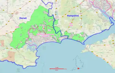
South West Hampshire/South East Dorset Green Belt
The South West Hampshire & South East Dorset Green Belt is a green belt environmental and planning policy that regulates the rural space in the South West region of England. It is mainly within the county of Dorset, extending cross border into Hampshire. Essentially, the function of the belt is to control development expansion in the South East Dorset conurbation and outlying towns and villages.[1] It is managed by local planning authorities on guidance from central government.

Geography
First created in 1958 (Hampshire)[2] and 1980 (Dorset),[3] land area taken up by the green belt is 36,000 hectares (360 km2; 140 sq mi), 0.3% of the total land area of England (2017).[4][5] Much of this is within the Dorset Council unitary authority area, with smaller portions within the Bournemouth,[6] Christchurch[7] and Poole[8] (BCP) unitary area.
The New Forest district[9] in Hampshire holds several portions of green belt, and the boundary of those are mainly contiguous with the New Forest National Park. Due to the belt lying across county borders, responsibility and co-ordination lies with the aforementioned local unitary and district councils as these are the local planning authorities.
See also
References
- Fawcett, Tony. "Green Belts: A greener future - Campaign to Protect Rural England".
- "New Forest District Green Belt Study Final Report Prepared by LUC July 2016". www.newforest.gov.uk.
- "Core Strategy 06 Green Belt Key Issue Paper - The History of the South East Dorset Green Belt" (PDF). www.dorsetforyou.gov.uk.
- "Department for Communities and Local Government: London - Local Planning Authority Green Belt: England 2016/17" (PDF). www.gov.uk.
- "Green Belts in England: Key facts - A series of factsheets on England's 14 Green Belts".
- "BOURNEMOUTH LOCAL PLAN: CORE STRATEGY Bournemouth Borough Council Adopted October 2012" (PDF). www.bournemouth.gov.uk.
- "CHRISTCHURCH AND EAST DORSET LOCAL PLAN Part 1 - Core Strategy" (PDF). www.dorsetforyou.gov.uk.
- "Poole Local Plan Review - Draft Green Belt Review". poole.gov.uk.
- "New Forest District Council Local Development Framework Core Strategy". www.newforest.gov.uk.