South Fork Stanislaus River
The South Fork Stanislaus River is a major tributary of the Stanislaus River in Tuolumne County, California. The river flows for 48.5 miles (78.1 km)[2] through rugged alpine and foothill areas of the Sierra Nevada.
| South Fork Stanislaus River | |
|---|---|
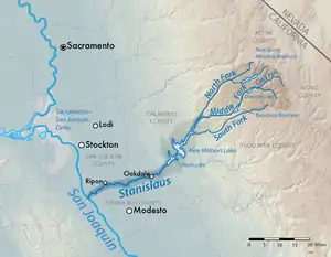
 Map of the Stanislaus River watershed, showing the South Fork | |
| Location | |
| Country | United States |
| State | California |
| Physical characteristics | |
| Source | Sierra Nevada |
| • location | Stanislaus National Forest |
| • coordinates | 38°13′29″N 119°49′05″W[1] |
| • elevation | 8,642 ft (2,634 m) |
| Mouth | Stanislaus River |
• location | New Melones Lake |
• coordinates | 38°04′26″N 120°25′24″W[1] |
• elevation | 1,050 ft (320 m) |
| Length | 48.5 mi (78.1 km)[2] |
| Discharge | |
| • location | near Long Barn[3] |
| • average | 85.1 cu ft/s (2.41 m3/s)[4] |
| • minimum | 0 cu ft/s (0 m3/s) |
| • maximum | 12,900 cu ft/s (370 m3/s) |
The river begins in Hay Meadow in the Emigrant Wilderness of the Stanislaus National Forest. It flows generally southwest, past Pinecrest, Cold Springs and Long Barn, then descends west through a canyon to the New Melones Lake reservoir where it meets the Stanislaus River.[5]
There are two dams on the South Fork: Strawberry Dam, which forms Pinecrest Lake, and Lyons Dam, impounding Lyons Reservoir, which provides municipal water supply to the Twain Harte area. Strawberry Dam is part of the Spring-Gap Stanislaus Hydroelectric Project, which uses water from the South Fork and Middle Forks of the Stanislaus River to generate power.[6]
See also
References
- "South Fork Stanislaus River". Geographic Names Information System. United States Geological Survey. 1981-01-19. Retrieved 2016-12-07.
- "National Hydrography Dataset via National Map Viewer". U.S. Geological Survey. Retrieved 2017-10-02.
- "USGS Gage #11298000 on the South Fork Stanislaus River near Long Barn, CA" (PDF). National Water Information System. U.S. Geological Survey. 1937–2013. Retrieved 2016-12-07.
- "USGS Gage #11298000 on the South Fork Stanislaus River near Long Barn, CA" (PDF). National Water Information System. U.S. Geological Survey. 1937–2013. Retrieved 2016-12-07.
- USGS Topo Maps for United States (Map). Cartography by United States Geological Survey. ACME Mapper. Retrieved 2016-12-07.
- "Stanislaus-Spring Gap : P-2130". Hydropower Reform Coalition. Retrieved 2016-12-07.