Slavo-Serbia
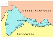
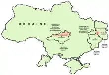
Slavo-Serbia or Slaveno-Serbia (Ukrainian: Слов'яносербія, romanized: Slov'yanoserbiya; Russian: Славяносербия, romanized: Slavyanoserbiya; Serbian: Славеносрбија / Slavenosrbija or Славосрбија / Slavosrbija; Slavo-Serbian or Slaveno-Serbian: Славо-Сербія or Славено-Сербія), was a territory of Imperial Russia between 1753-64. It was located by the right bank of the Donets River between the Bakhmutka River (Бахмут) and Luhan (Лугань) rivers. This area today constitutes the territories of present-day Luhansk Oblast and Donetsk Oblast of Ukraine. The administrative centre of Slavo-Serbia was Bakhmut (Bahmut).
| Slavo-Serbia Славеносрбија / Slavenosrbija Слов'яносербія Славяносербия | |||||||
|---|---|---|---|---|---|---|---|
| territory of Russian Empire | |||||||
| 1753–1764 | |||||||
 | |||||||
| Capital | Bakhmut (Bahmut) | ||||||
| History | |||||||
• Established | 1753 | ||||||
• Abolished | 1764 | ||||||
| |||||||
| Today part of | |||||||
History
By the decree of the Senate of May 29, 1753, the free lands of this area were offered for settlement to Serbs, Vlachs (Wallachians), Bulgarians, Greeks and other Balkan peoples of Orthodox Christian denomination to ensure frontier protection and development of this part of the steppes.[1]
Slavo-Serbia was directly governed by Russia's Governing Senate and College of War. The settlers eventually formed the Bakhmut hussar regiment in 1764. Also in 1764, Slavo-Serbia was transformed into the Donets uyezd of Yekaterinoslav Governorate (now in Dnipropetrovs'ka oblast', Ukraine). Commandants of Slavo-Serbia were Colonels Rajko Depreradović and Jovan Šević. These Serbian colonels led their soldiers in various Russian military campaigns; in peacetime they kept the borderlands, along with the Cossacks, free from incursions by other states.
Demographics
The province had ethnically diverse population that included Serbs, Vlachs (Wallachians), and others. In 1755, the population of Slavo-Serbia numbered 1,513 inhabitants (of both genders). In 1756, in the regiment of Jovan Šević, there were 38% Serbs, 23% Vlachs, and 22% others.[2] In 1763, the population of Slavo-Serbia numbered 3,992 male inhabitants, of whom only 378 were Serbs.
Places of Slavo-Serbia
| Serbian name (mid-18th century)(1) | Ukrainian name (mid-18th century)(2) | Later or current Ukrainian (Russian) name(2) | |||||||||||||||||||||||||||
|---|---|---|---|---|---|---|---|---|---|---|---|---|---|---|---|---|---|---|---|---|---|---|---|---|---|---|---|---|---|
| Bakhmut (Bahmut) | Bachmut — Бахмут | Bakhmut — Бахмут | |||||||||||||||||||||||||||
| Serebrjanka | Serebrjanka — Серебрянка | Serebryanka — Серебрянка (Серебрянка) | |||||||||||||||||||||||||||
| Privoljno | Pryvolne — Привольне | Pryvillya — Привілля (Приволье) | |||||||||||||||||||||||||||
| Verchnja | Verchnje — Верхнє | - | |||||||||||||||||||||||||||
| Nižnje | Nyžnje — Нижнє | Nyzhnye — Нижнє (Нижнее) | |||||||||||||||||||||||||||
| Lugansko | Luhanske — Луганське | Luhanske — Луганське (Луганское) | |||||||||||||||||||||||||||
| Trojicka | Troicke — Троїцьке | Troyitske — Троїцьке (Троицкое) | |||||||||||||||||||||||||||
| Kalinovo | Kalynovske — Калиновське | Kalynove — Калинове (Калиново) | |||||||||||||||||||||||||||
| Krimsko | Krymske — Кримське | Krymske — Кримське (Крымское) | |||||||||||||||||||||||||||
| Podgorno | Pidgorne — Підгорне | Slovianoserbsk — Слов'яносербськ (Славяносербск) | |||||||||||||||||||||||||||
| Horoše | Xoroše — Хороше | Khoroshe — Хороше | |||||||||||||||||||||||||||
| Čerkasko | Čerkas'ke — Черкаське | Cherkaskyi Brid — Черкаський Брід (Черкасский Брод) / Zymohirya — Зимогір'я (Зимогорье) | |||||||||||||||||||||||||||
| Žovta | Žovte — Жовте | Zhovte — Жовте | |||||||||||||||||||||||||||
| Krasni Jar | Krasnyj Jar — Красний Яр | Krasnyi Yar — Красний Яр (Красный Яр) | |||||||||||||||||||||||||||
| Kamjani Brod | Kamjanyj Brid — Кам'яний Брід | Kamianyi Brid — Кам'яний Брід (Каменный Брод) | |||||||||||||||||||||||||||
| Vergunci | Vergunka — Вергунка | Verhunka — Вергунка | |||||||||||||||||||||||||||
| Notes: (1)Serbian names given in the Serbian Latin alphabet. (2)Ukrainian names are given in Latin transliterations and native Cyrillic forms. | |||||||||||||||||||||||||||||
Notes
- Historical Dictionary of Ukraine by Ivan Katchanovski, Zenon E. Kohut, Bohdan Y. Nebesio, and Myroslav Yurkevich, vol. 2, Scarecrow Press, 2013; ISBN 081087847X, pp. 392-93, 584
- Posunjko 2002, p. 36
References
Mita Kostić (2001). "Nova Srbija i Slavenosrbija" (PDF). Novi Sad. Archived from the original (PDF) on 2009-03-06. Cite journal requires |journal= (help)
- Pavel Rudjakov, Seoba Srba u Rusiju u 18. veku, Beograd, 1995.
- Olga M. Posunjko, Istorija Nove Srbije i Slavenosrbije, Novi Sad, 2002.
 Map of present-day Ukraine with the territory of Slavo-Serbia indicated with red on the right side.
 Slavo-Serbia location map.
 Map of Slavo-Serbia.