Sint Odiliënberg
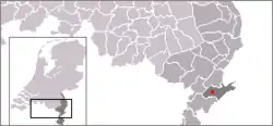
Sint Odiliënberg is a small village in southeast Netherlands, It is located in Roerdalen, Limburg, in the Roer River valley.
Sint Odiliënberg | |
|---|---|
.jpg.webp) Sint Odiliënberg on the Roer river | |
 | |
| Coordinates: 51°08′35″N 6°00′10″E | |
| Country | Netherlands |
| Province | Limburg |
| Municipality | Roerdalen |
| Population (1 January 2014) | 3,214 |
| Dialling code | 0475 |
| Major roads | N293 |
History
Romans settled here very early. In 706 missionary monks from Ireland, Saints Wiro, Plechelmus, and Otgerus, built a monastery there, which was important in the Christianisation of the Netherlands. In the time of the Viking invasions the Utrecht clergy found shelter here. At first it was a secular collegiate chapter, which later moved to Roermond in the 14th century. A community of the Canons Regular of the Holy Sepulchre settled on the hill during that period.
After the Eighty Years' War, this area came under Spanish rule; it was ceded to the Dutch Republic in 1715. Until the French municipal reorganisation, St. Odiliënberg belonged to the administrative division known as Ambt Montfort. Around 1810 it became a separate commune/municipality. In 1991 the municipality of Sint Odiliënberg merged into Ambt Montfort, which in January 2007 merged into Roerdalen.
Attractions
Standing on a hill is a Romanesque basilica with two towers dating from the eleventh century. Next to the basilica is a 10th-century chapel, originally the parish church.
 Sint Odiliënberg, basilica
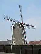
 Sint Odiliënberg, windmill: molen van Verbeek
Notable residents
- Connie Palmen, writer, born in St. Odiliënberg
- Geert Chatrou, professional whistler, born in St. Odiliënberg
- Twan de Ruiter, professional woodworker and materials planner, born in St. Odiliënberg
External links
- J. Kuyper, Gemeente Atlas van Nederland, 1865-1870, "Sint Odiliënberg". Map of the former municipality, around 1868.