Silurian Hills
The Silurian Hills are a small range of hills in the Mojave Desert, southeast of Death Valley National Park, in southern California. The surrounding lower elevation lands provide important connectivity habitat between nearby mountain ranges. The area provides critical habitat and movement corridors for bighorn sheep, desert tortoises, nesting golden eagles, kit foxes and burrowing owls.[2] The Silurian Valley is a largely undisturbed valley that supports wildlife and is an important link for this portion of the northern Mojave Desert.[3]
| Silurian Hills | |
|---|---|
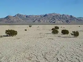
 View of Silurian Hills beyond Silurian Dry Lake, and the occasional creosote bush. | |
| Highest point | |
| Elevation | 1,056 ft (322 m) |
| Geography | |
 location of Silurian Hills in California [1] | |
| Country | United States |
| State | California |
| Region | Mojave Desert |
| District | San Bernardino County |
| Range coordinates | 35°31′59.912″N 116°7′38.059″W |
| Topo map | USGS Silurian Lake |
Geography
The range lies in a northwest-southeasterly direction, and is about 9 miles (14 km) long. The Shadow Mountains lies to the east, and the Avawatz Mountains, on the west, across the Silurian Valley.[4] Salt Creek[5] flows intermittently through the 19-mile-long (30 km) Silurian Valley connecting Silver Lake[6] to the south with Death Valley to the north.[7] Other nearby ranges are Salt Spring Hills and Sperry Hills.
Sites of interest
Highway 127, traversing through the Silurian Valley in a northwest-southeasterly direction, connects three protected areas: Joshua Tree National Park, the Mojave National Preserve and Death Valley National Park. This portion of highway 127 has been described as one of the most scenic in the state.[3] The small community of Halloran Springs near Interstate 15 lies about 12 miles (19 km) to the southeast.
The Old Spanish Trail developed several variations to take advantage of better water sources and to shorten the length and time of travel. The Kingston Cutoff went southwest from Mountain Springs, Nevada, to Silurian Lake.[8][9]
References
- "Silurian Hills". Geographic Names Information System. United States Geological Survey. Retrieved 2009-05-04.
- Prichett, Jack and Brown, Brian (November 14, 2014) "Silurian Valley — a threatened desert treasure: Guest commentary" San Bernardino County Sun
- Clarke, Chris (November 25, 2014) "Feds Deny Solar Project Near Mojave National Preserve" KCET ReWire newsletter
- U.S. Geological Survey Geographic Names Information System: Silurian Valley
- U.S. Geological Survey Geographic Names Information System: Salt Creek
- U.S. Geological Survey Geographic Names Information System: Silver Lake
- Anderson, Kirk C.; Wells, Stephen G. (2003), "Latest Quaternary Paleohydrology of Silurian Lake and Salt Spring Basin, Silurian Valley, California", in Enzel, Yehouda; Wells, Stephen G.; Lancaster, Nicholas (eds.), Paleoenvironments and Paleohydrology of the Mojave and Southern Great Basin Deserts, America Special Paper, Boulder, Colorado: Geological Society of America, pp. 129–141
- Cart, Julie (November 8, 2014) "Will renewable energy ruin an 'irreplaceable' Mojave desert oasis?" Los Angeles Times
- Cart, Julie (November 20, 2014) "BLM rejects application for Silurian Valley energy project" Los Angeles Times
- Allan, Stuart (2005). California Road and Recreation Atlas. Benchmark Maps. p. 97. ISBN 0-929591-80-1.