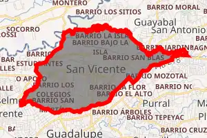
San Vicente, Moravia
San Vicente is a district of the Moravia canton, in the San José province of Costa Rica.[1][2]
San Vicente | |
|---|---|

San Vicente district | |
 San Vicente San Vicente district location in Costa Rica | |
| Coordinates: 9.9636155°N 84.0453507°W | |
| Country | |
| Province | San José |
| Canton | Moravia |
| Area | |
| • Total | 5.39 km2 (2.08 sq mi) |
| Elevation | 1,231 m (4,039 ft) |
| Population (2011) | |
| • Total | 30,998 |
| • Density | 5,800/km2 (15,000/sq mi) |
| Time zone | UTC−06:00 |
| Postal code | 11401 |
Locations
The district of San Vicente comprises the city of the same name and the following neighborhoods (by 2009): Alondra, Americano, Américas, Bajo Isla, Bajo Varelas, Barro de Olla, Caragua, Carmen, Colegios, Colegios Norte, Chaves, El Alto (part of), Flor, Florencia, Guaria, Guaria Oriental, Isla, Jardines de Moravia, La Casa, Ladrillera, Robles, Romeral, Sagrado Corazón, San Blas, San Jorge, San Martín, San Rafael, Santa Clara (part of), Santo Tomás and Saprissa.
Education and Culture
The Escuela Japonesa de San José is the only Japanese international school in Costa Rica, and located in San Vicente.[4]
Demographics
| Historical population | |||
|---|---|---|---|
| Census | Pop. | %± | |
| 1864 | 979 | — | |
| 1883 | 1,194 | 22.0% | |
| 1892 | 1,664 | 39.4% | |
| 1927 | 1,881 | 13.0% | |
| 1950 | 4,451 | 136.6% | |
| 1963 | 9,188 | 106.4% | |
| 1973 | 15,552 | 69.3% | |
| 1984 | 24,661 | 58.6% | |
| 2000 | 31,693 | 28.5% | |
| 2011 | 30,998 | −2.2% | |
|
Instituto Nacional de Estadística y Censos[5] |
|||
For the 2011 census, San Vicente had a population of 30,998 inhabitants. [7]
Transportation
Road transportation
The district is covered by the following road routes:
References
- "Declara oficial para efectos administrativos, la aprobación de la División Territorial Administrativa de la República N°41548-MGP". Sistema Costarricense de Información Jurídica (in Spanish). 19 March 2019. Retrieved 26 September 2020.
- División Territorial Administrativa de la República de Costa Rica (PDF) (in Spanish). Editorial Digital de la Imprenta Nacional. 8 March 2017. ISBN 978-9977-58-477-5.
- "Área en kilómetros cuadrados, según provincia, cantón y distrito administrativo". Instituto Nacional de Estadística y Censos (in Spanish). Retrieved 26 September 2020.
- "学校概要." Escuela Japonesa de San José. Retrieved on 7 July 2018. "学校所在地 Barrio Los Colegios,de Colegio de Farmacéuticos 50mts.al este,Moravia, San José,Costa Rica"
- "Instituto Nacional de Estadística y Censos" (in Spanish).
- "Sistema de Consulta de a Bases de Datos Estadísticas". Centro Centroamericano de Población (in Spanish).
- "Censo. 2011. Población total por zona y sexo, según provincia, cantón y distrito". Instituto Nacional de Estadística y Censos (in Spanish). Retrieved 26 September 2020.