Saatse Boot
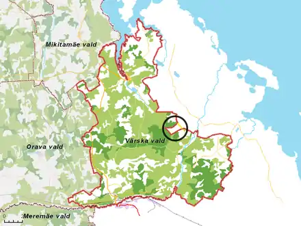
The Saatse Boot (Estonian: Saatse saabas; Russian: Саатсеский сапог) is a boot-shaped area of Russian territory of 115 hectares (280 acres) that extends through the road number 178 between the Estonian villages of Lutepää and Sesniki (themselves between the larger settlement Värska and village of Saatse) in Värska Parish.

A short distance north of Saatse boot, the Russian border crosses road number 178 again, leaving a very small patch of triangle shaped Russian territory west of road number 178, between Värska and Saatse. The same rules apply here as in Saatse boot itself: Vehicles can cross, but stopping is not allowed. A small track goes around the triangle-shaped, tiny piece of Russian territory, remaining entirely on Estonian territory.
Russia does not require any permit for driving through the area, though it is forbidden to pass through the area on foot or stop one's car. If the vehicle is stopped within the driver's control, occupants can be arrested and interrogated, with fines likely to be issued. If the halt is beyond the driver's control (e.g. if fuel runs out) the Estonian border section of Saatse is to be contacted and the occupants are not to exit the vehicle until they arrive and provide assistance. [1] The road has a gravel surface. Russia allows Estonia to maintain the road (when it can be done by machines not needing to stop), but has denied permission to have the road paved.[1]
In 2008 a new road connecting Sesniki to Matsuri opened, making it possible to reach the aforementioned villages without necessarily passing through the 'boot'. This is however a 17-kilometre (11 mi) detour if arriving to Saatse from Värska. [2] Google's road planner suggests to take a detour via road 63 and a left turn to Vedernika. A shorter detour (only 3km) is available (57°53′39″N 27°38′35″E), but it runs partly on sandy one-lane bush tracks that might become hard to pass after bad weather. On the Russian side there is an ATV track of even lower standard, used by the border control. The Irish AA road planner allows you to plan your trip from Värska to Saatse through Saatse boot, if you force it to do so, by putting a 'via'-marker on the Russian side of the Saatse boot. [3]

Background
The current Estonian–Russian border in Setumaa was established in 1944 when most of the territory of Estonian Petseri County was transferred to the Russian SFSR. During the Soviet era it was merely an administrative border between two constituent republics of the Soviet Union. Estonia regained independence in 1991 and since then the same border (officially referred to as 'line of control' by Estonia) has been the international border between the two countries. The reason for the odd shaped border here is that the area was historically owned by a farm at the village of Gorodishche located 1.5 km (1 mile) further east.[1]
Future
According to the new Estonian–Russian border treaty, the boot will be straightened out and the border oddity will disappear.[4] The area of the boot will be transferred to Estonia in exchange for two patches of land in Värska and Meremäe Parishes. The treaty was signed in 2005 by the foreign ministers of Estonia and Russia, and again in 2014 after renegotiations.[5] Up until December 2020, the border treaty had not (yet) been executed, so the border oddity of Saatse boot remained in place.
References
- Border tweak steals tourism magnet (Postimees 7 Aug 2013)
- Google Maps, From church in Värska to church in Saatse Google Maps avoids Saatse boot in this itinerary, even with intermediate stops inserted right at Russian border
- The AA, From church in Värska to church in Saatse itinerary forced through Saatse boot, with via-markers, is 17 kilometres, consulted 9th of December 2020
- "Estonia, Russia to exchange 128.6 hectares of land under border treaty". Postimees. 2013-05-28. Retrieved 11 March 2014.
- https://www.youtube.com/watch?v=iGjPn8V4O9E&t=152s