Rotorua Lakes
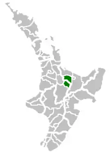
Rotorua Lakes District, known as Rotorua District from 1979 to 2014, is a territorial authority district in the North Island of New Zealand. It has one urban area of significant size, the city of Rotorua. The district is governed by Rotorua Lakes Council, which is headquartered in Rotorua and is headed by a mayor. The district falls within two regional council areas, with the majority of the area and Rotorua city in the Bay of Plenty region and the rest in the Waikato region.[1] Steve Chadwick has been the mayor of Rotorua since the 2013 local elections.

History
Rotorua has an unusual history as the town was built by the Government as a tourist destination in the 1880s.[2] Through the Rotorua Borough Act 1922, which achieved royal assent on 28 September 1922, the Rotorua Borough was formed.[3] The inaugural elections for mayor were held in February 1923 and Cecil Clinkard was successful.[4][5] In 1962, Rotorua was proclaimed a city.[6] In 1979, the status was changed to a district when Rotorua City and Rotorua County amalgamated.[7] The district council held its first meeting on 2 April 1979.[8] At the 27 November 2014 council meeting, it was decided to change the operating name of the district to Rotorua Lakes Council. Since then, the district has been known as Rotorua Lakes and the council's web domain changed from www.rdc.govt.nz to rotorualakescouncil.nz.[9]
Demographics
| Year | Pop. | ±% p.a. |
|---|---|---|
| 2006 | 65,901 | — |
| 2013 | 65,280 | −0.14% |
| 2018 | 71,877 | +1.94% |
| Source: [10] | ||
Rotorua District had a population of 71,877 at the 2018 New Zealand census, an increase of 6,597 people (10.1%) since the 2013 census, and an increase of 5,976 people (9.1%) since the 2006 census. There were 25,056 households. There were 35,148 males and 36,729 females, giving a sex ratio of 0.96 males per female. Of the total population, 16,113 people (22.4%) were aged up to 15 years, 14,148 (19.7%) were 15 to 29, 31,248 (43.5%) were 30 to 64, and 10,365 (14.4%) were 65 or older. Figures may not add up to the total due to rounding.
Ethnicities were 63.3% European/Pākehā, 40.1% Māori, 5.4% Pacific peoples, 9.5% Asian, and 1.6% other ethnicities. People may identify with more than one ethnicity.
The percentage of people born overseas was 17.8, compared with 27.1% nationally.
Although some people objected to giving their religion, 49.9% had no religion, 35.0% were Christian, and 8.2% had other religions.
Of those at least 15 years old, 9,876 (17.7%) people had a bachelor or higher degree, and 10,434 (18.7%) people had no formal qualifications. The median income was $28,000. The employment status of those at least 15 was that 27,117 (48.6%) people were employed full-time, 8,541 (15.3%) were part-time, and 3,378 (6.1%) were unemployed.[10]
Geography
Rotorua Lakes covers 2,409 square kilometres (930 sq mi).[11] The district's area is 61.52% in the Bay of Plenty region and 38.48% in the Waikato region. Adjacent districts (in a clockwise direction starting in the north) are Western Bay of Plenty, Whakatāne, Taupo, and South Waikato.[12][13]
The Bay of Plenty portion of the district includes the settlements of Rotorua, Ngongotahā Valley, Mamaku, Hamurana, Mourea, Rotoiti Forest, Lake Rotoma, Lake Okareka, Lake Tarawera, Rerewhakaaitu, and Kaingaroa Forest. The Waikato portion includes the settlements of Waiotapu, Reporoa, Broadlands, Mihi, Waikite Valley, Ngakuru, and Atiamuri.
Local government
Local council
Every three years, a mayor and the district councillors are elected in local elections. In the most recent elections in 2019, Steve Chadwick was re-elected as mayor and ten councillor were returned. Rotorua Lakes uses the first-past-the-post (FPP) voting system and elects its councillors at-large.[14]
Sister cities
Rotorua has four sister cities:[15]
 Klamath Falls, Oregon
 Beppu, Kyushu
.svg.png.webp) Lake Macquarie, New South Wales
Lake Macquarie, New South Wales The Wuzhong District of Suzhou, China
References
- "About the Rotorua District". Rotorua Lakes Council. 3 July 2019. Retrieved 20 May 2020.
- "Rotorua". Ministry for Culture and Heritage. Retrieved 13 May 2020.
- "Rotorua Borough Act 1922". Parliamentary Counsel Office. Retrieved 13 May 2020.
- "Cecil Clinkard". Rotorua District Library. Retrieved 13 May 2020.
- "Mayor of Rotorua". Auckland Star. 28 February 1923. p. 3. Retrieved 13 May 2020.
- McKinnon, Malcolm (25 May 2015). "Volcanic Plateau places - Rotorua city". Te Ara: The Encyclopedia of New Zealand. Retrieved 13 May 2020.
- "John Keaney, CBE QSO". Rotorua District Library. Retrieved 13 May 2020.
- "Coat of Arms". Rotorua Lakes Council. Retrieved 13 May 2020.
- "District council becomes Rotorua Lakes Council" (Press release). Rotorua: Rotorua Lakes Council. 1 December 2014. Retrieved 13 May 2020.
- "Statistical area 1 dataset for 2018 Census". Statistics New Zealand. March 2020. Rotorua District (024). 2018 Census place summary: Rotorua District
- "Rotorua District Council". Department of Internal Affairs. Retrieved 13 May 2020.
- "Waikato Regional Council". Department of Internal Affairs. Retrieved 13 May 2020.
- "Bay Of Plenty". Department of Internal Affairs. Retrieved 13 May 2020.
- Lampp, Warwick (17 October 2019). "Rotorua Lakes Council – 2019 Triennial Elections – Declaration of Results" (PDF). Rotorua Lakes Council. Retrieved 14 May 2020.
- "Rotorua Sister Cities". Rotorua Lakes Council. 20 November 2019. Retrieved 14 May 2020.