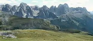
Rosengarten group
The Rosengarten group (Italian: Catinaccio [katiˈnattʃo], Ladin: Ciadenac, Ciadenáze) is a massif in the Dolomites of northern Italy. It is located between the Tierser Tal and Eggental in South Tyrol and the Fassa Valley in Trentino.
| Rosengarten | |
|---|---|
 Rosengarten seen from Schlern summit | |
| Highest point | |
| Elevation | 3,002 m (9,849 ft) |
| Coordinates | 46°28′N 11°39′E |
| Naming | |
| English translation | Rose garden |
| Language of name | German |
| Geography | |
| Location | Trentino-Alto Adige/Südtirol, Italy |
| Parent range | Dolomites |
| Climbing | |
| First ascent | 1873 |
One peculiarity of the Rosengarten is the pink shade, owing to the presence of the mineral dolomite, which takes in the sunset and "glows", as celebrated in the Bozner Bergsteigerlied. Meaning "Rose garden" in German, the name refers to the legend of King Laurin and his Rose Garden, a traditional story explaining the outer appearance of the mountain range.[1][2]
Summits
The highest peak is the Kesselkogel at 3,002 m (9,849 ft) above sea level. Other peaks include:
- Rosengartenspitze - 2,981 m (9,780 ft)
- Vajolet-Türme - 2,813 m (9,229 ft)
- Laurinswand (Croda di Re Laurino) - 2,813 m (9,229 ft)
- Tscheiner-Spitze (Cima Sforcella) - 2,813 m (9,229 ft)
- Rotwand (Roda di Vaèl) - 2,806 m (9,206 ft)
- Teufelswand (Croda Davoi) - 2,727 m (8,947 ft)
References
- "The legend of King Laurin and his Rose garden". Retrieved 25 July 2014.
- Wolff, Karl Felix (2013). The Dolomites and their legends. Bozen: Edition Raetia. ISBN 978-88-7283-436-7. Archived from the original on 2013-08-13.
| Wikimedia Commons has media related to Rosengarten group. |
This article is issued from Wikipedia. The text is licensed under Creative Commons - Attribution - Sharealike. Additional terms may apply for the media files.