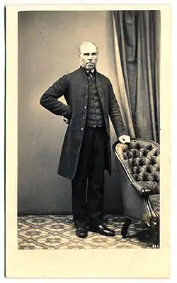
Robert Dixon (explorer)
Robert Harald Lindsay Dixon (1800–1858) was an Australian surveyor and explorer, born in Darlington, England.[2]
Robert Dixon | |
|---|---|
 Robert Dixon | |
| Born | 1800 Darlington, County Durham, England |
| Died | 8 April 1858 Sydney, Australia |
| Occupation | Surveyor |
| Spouse(s) | Margaret Sibly |
| Children | 6 (Langford Dangar, Joel and Jerome)[1] |
| Parent(s) | James and Elizabeth |
Arrival in Tasmania
Dixon arrived in Tasmania (then Van Diemen's Land) in May 1821 with his brother George. For two years they worked for Edward Lord, tending his cattle station.
In 1823 they were each granted 100 acres of land in the valley of the River Clyde and in 1824 each received an additional 200 acres.
Sydney
In July 1826 Dixon was bought out by his brother and went to Sydney, where he was appointed assistant surveyor in the Surveyor-General's Department under Lieutenant John Oxley. One of his first tasks was to survey the southern districts of New South Wales as far as the Illawarra.
The following year he joined Major Thomas Mitchell and Major Edmund Lockyer on a journey to survey the Grose Valley near Mount Victoria. The party was stopped by rough terrain and the men could not continue.
In 1827 Dixon attempted to explore and survey the Burragorang Valley. He became lost and almost died.
Over the following two years, Dixon made a number of survey trips to the Blue Mountains and in 1829 he tried again to survey the Grose Valley but was unsuccessful. He did, however, obtain a trigonometrical survey of Mount King George and his surveys of the Blue Mountains allowed Mitchell to establish a new road to Bathurst later that year.
Goulburn and Southern NSW
In 1828 Dixon surveyed the area to the north of what is now the town of Goulburn which at that time was known as the Goulburn Plains. The original township was based on the banks of the Wollondilly River to the south of what is now the Pejar Dam but was moved to its present site in 1833. The area Dixon surveyed has, over subsequent years, been settled and is now part of modern Goulburn North.
Dixon continued south and in 1830 he started to survey the area near Queanbeyan by following the Molonglo River to its junction with the Murrumbidgee River. He continued west beyond the area which is now the site of modern Canberra.
Dixon was later reprimanded by Mitchell for failing to ascertain Aboriginal place names[2] and a number of the place-names originally proposed by Dixon were later disregarded in favour of names of Aboriginal origin.
Northern NSW and return to England
In 1831–32 Dixon carried out surveys in the Upper Hunter and New England districts.
In October 1833, Dixon was assigned to survey the mountain ranges between the Lachlan River and the Macquarie River. Rather than follow specific instructions, Dixon followed the then-unexplored Bogan River for 108 kilometres and later returned to Bathurst without having surveyed the ranges in the original brief.
In 1836 he applied for two years leave to go to England on 'urgent private business'. He departed from Sydney to London on the Abel Gower in July 1836.[3] In 1837, while in London, he published a map of Australia[4] that he had created by compiling official surveys and documents. When he returned to Sydney in July 1838 he was subsequently refused reinstatement by Mitchell.
Moreton Bay


Having failed to gain reinstatement, Dixon moved to Moreton Bay. On 24 July 1839 he married Margaret Sibly, the daughter of James and Elizabeth Sibly of St Neot in Cornwall.
During that year, Dixon, with assistant surveyors Granville Stapylton and James Warner, began a trigonometrical survey of Moreton Bay for the Government to facilitate free settlement.[5] A baseline of 3 miles (4.8 km) was measured on Normanby Plains (today's Harrisville, south of Ipswich) as a foundation for the triangulation. Dixon was instructed to compile a plan of the district for land sales and town reserves.[6]
In January 1840, Dixon was promoted to surveyor in charge of the Moreton Bay district, but was suspended after an altercation with Lieutenant Owen Gorman, commandant of the Moreton Bay penal settlement (now Brisbane). Dixon's convict servant was arrested and Dixon's response saw him charged with attempting to incite a mutiny. Dixon denied the charges and lodged counter-charges of improper conduct against the Lieutenant. The Lieutenant was later relieved of his appointment as magistrate and the charges against Dixon were not progressed.
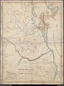
Dixon, however, was not reinstated. He had again offended the Government by publishing his own map of Moreton Bay in 1841 without permission.[7] This angered Governor Sir George Gipps,[8] resulting in Dixon's disgrace and his replacement by James Warner.[7]
When Moreton Bay was opened to free settlement in 1842, Dixon applied for the lease over a number of government buildings. When this was refused, he moved to Toongabbie.
Dixon found little available work and returned to England in 1846. He returned to Australia in 1852, spuriously claiming that he had been hired to manage a gold mine.
Death
Dixon died, at age 58, on 8 April 1858 in Sydney. He was survived by his wife and three of their six children.[2]
Historical contribution
Dixon is credited with having first surveyed and named a number of areas along the East Coast of Australia including:
- Cronulla, New South Wales – the named based on the Aboriginal word kurranulla.
- Gunnamatta Bay, New South Wales.
- The Oaks, New South Wales – and surrounding areas.
- Otford, New South Wales – originally named Bulgo by Dixon.
- Russell Island, Queensland.[7]
- Wellington Point, Queensland.
Legacy
Dixon, Stapylton and Warner are commemorated on a plaque at the Land Centre, Woolloongabba in Brisbane (27.4848°S 153.0353°E). The plaque was placed by the Queensland Division of the Australian Institute of Surveyors and unveiled on 7 May 1989 by the Surveyor-General of Queensland K. J. Davies and the Surveyor-General of New South Wales D. M. Grant.[9]
References
- Parish clerks on line St Neots
- Cranfield, Louis R. (1966), "Dixon, Robert (1800–1858)", Australian Dictionary of Biography, Melbourne University, pp. 309–310, archived from the original on 24 May 2011, retrieved 2 March 2007
- "Departures". The Colonist. 4 August 1836. Retrieved 14 September 2010.
- "New Topographical Map of the Colony". The Colonist. 4 August 1838. Archived from the original on 26 January 2020. Retrieved 14 September 2010.
- Johnson, Murray; Kay Saunders (2007). Working the land: an historical overview of Boonah and its northern district (PDF). Queensland State Archives. p. 10. ISBN 0734515308. Archived (PDF) from the original on 23 September 2015. Retrieved 24 June 2020.
- Gibbs, George (1841). Copy of a despatch from Sir George Gipps ... to the Secretary of State for the colonies, transmitting a report of the progressive discovery and occupation of that colony during the period of his administration of the government. Dixon, Robert. House of Commons.
- Horton, Helen (1983). Islands of Moreton Bay. Spring Hill, Queensland: Boolarong Publications. p. 77. ISBN 0-908175-67-1.
- de Strzelecki, Paul Edmond (1845), Physical Description of New South Wales and Van Diemen's Land: Accompanied by a Geological Map, Sections, and Diagrams, London, United Kingdom: Longman, Brown, Green, and Longmans, p. 38
- "First Surveyors in Queensland". Monument Australia. Archived from the original on 24 June 2020. Retrieved 24 June 2020.
External links
| Wikimedia Commons has media related to Robert Dixon (explorer). |