Reineskarvet
Reineskarvet is a significant mountain in the municipality of Ål in Buskerud, Norway.[2]
| Reineskarvet | |
|---|---|
| Highest point | |
| Elevation | 1,791 m (5,876 ft) |
| Prominence | 435 m (1,427 ft) [1] |
| Coordinates | 60°46′42″N 8°9′57″E |
| Geography | |
| Location | Ål, Buskerud, Norway |
| Topo map | 1516 I Gyrinosvatnet |

Reineskarvet
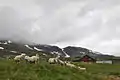
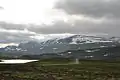
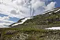
It is located in the Skarvheimen highland area between Jotunheimen and Hardangervidda, on the north side of Hallingdalen, west of Hemsedal. Reineskarvet looks like Hallingskarvet and lies parallel to it a bit farther north east. The highest point lies in the western end, while there is a summit in the eastern end with elevation 1732 m, popular for hiking.[3]
Gallery

References
- Toppomania, list of 25 highest in Buskerud Archived 2008-06-23 at the Wayback Machine
- Geir Thorsnæs. "Reineskarvet". Store norske leksikon. Retrieved October 1, 2016.
- Geir Thorsnæs. "Skarvheimen". Store norske leksikon. Retrieved October 1, 2016.
This article is issued from Wikipedia. The text is licensed under Creative Commons - Attribution - Sharealike. Additional terms may apply for the media files.