Ranch to Market Road 1111
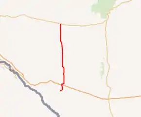
Ranch to Market Road 1111 (RM 1111) is a 47 miles (76 km) long Ranch to Market Road entirely in Hudspeth County in the U.S. state of Texas maintained by the Texas Department of Transportation (TxDOT). It runs generally from south to north.
| ||||
|---|---|---|---|---|

| ||||
| Route information | ||||
| Maintained by TxDOT | ||||
| Length | 47.018 mi[1] (75.668 km) | |||
| Existed | 1948–present | |||
| Major junctions | ||||
| South end | Cowan Rd. / Indian Hot Springs Rd. | |||
| North end | ||||
| Location | ||||
| Counties | Hudspeth | |||
| Highway system | ||||
| ||||
Route description
The southern terminus of RM 1111 is approximately 5 miles (8.0 km) south of Sierra Blanca in at the intersection of Cowan Rd. and Indian Hot Springs Rd. From here, the route runs north through Sierra Blanca along Archie Rd., intersecting I-10 at exit 107. RM 1111 turns east, then north before ending at US 62 / US 180 east of Cornudas.[1][2][3][4][5]
History
![]() RM 1111 was designated on December 16, 1948 as Farm to Market Road 1111 from US 80 (present-day Bus. I-10-C), northward approximately 24 miles (39 km). On May 23, 1951, this was extended a further 19 miles (31 km) to US 62. On December 6, 1957, FM 1111 became RM 1111 and the section south of present-day Bus. I-10-C was added, replacing RM 2528.[6][1]
RM 1111 was designated on December 16, 1948 as Farm to Market Road 1111 from US 80 (present-day Bus. I-10-C), northward approximately 24 miles (39 km). On May 23, 1951, this was extended a further 19 miles (31 km) to US 62. On December 6, 1957, FM 1111 became RM 1111 and the section south of present-day Bus. I-10-C was added, replacing RM 2528.[6][1]
Major intersections
The entire route is in Hudspeth County.
| Location | mi[7] | km | Destinations | Notes | |
|---|---|---|---|---|---|
| | 0.0 | 0.0 | Cowan Rd. / Indian Hot Springs Rd. south of Sierra Blanca | Southern terminus | |
| Sierra Blanca | 4.7 | 7.6 | |||
| 4.8 | 7.7 | Former US 80 | |||
| | 43.5 | 70.0 | |||
| | 47.0 | 75.6 | Northern terminus | ||
| 1.000 mi = 1.609 km; 1.000 km = 0.621 mi | |||||
References
- Transportation Planning and Programming Division (n.d.). "Ranch to Market Road No. 1111". Highway Designation Files. Texas Department of Transportation. Retrieved 2011-09-22.
- Transportation Planning and Programming Division (2012). Texas County Mapbook (PDF) (Map) (2012 ed.). 1:120,000. Texas Department of Transportation. p. 78. OCLC 867856197. Retrieved 2011-09-22.
- Transportation Planning and Programming Division (2012). Texas County Mapbook (PDF) (Map) (2012 ed.). 1:120,000. Texas Department of Transportation. p. 79. OCLC 867856197. Retrieved 2011-09-22.
- Transportation Planning and Programming Division (2012). Texas County Mapbook (PDF) (Map) (2012 ed.). 1:120,000. Texas Department of Transportation. p. 80. OCLC 867856197. Retrieved 2011-09-22.
- Transportation Planning and Programming Division (2012). Texas County Mapbook (PDF) (Map) (2012 ed.). 1:120,000. Texas Department of Transportation. p. 81. OCLC 867856197. Retrieved 2011-09-22.
- (PDF) https://publicdocs.txdot.gov/minord/MinuteOrderDocLib/003676504.pdf. Missing or empty
|title=(help) - Google (2011-09-22). "Route of RM 1111" (Map). Google Maps. Google. Retrieved 2011-09-22.
External links
![]() Geographic data related to Ranch to Market Road 1111 at OpenStreetMap
Geographic data related to Ranch to Market Road 1111 at OpenStreetMap
