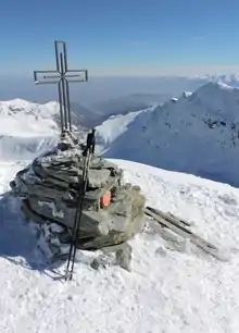
Punta Tempesta
Punta Tempesta is a 2,679 m a.s.l. mountain of the Cottian Alps, located in Italy.
| Punta Tempesta | |
|---|---|
 | |
| Highest point | |
| Elevation | 2,679 m (8,789 ft) [1] |
| Prominence | 309 m (1,014 ft) [2][1] |
| Listing | Alpine mountains 2500-2999 m |
| Coordinates | 44°25′18.62″N 07°08′20.83″E |
| Geography | |
 Punta Tempesta Alps | |
| Location | Piedmont, Italy |
| Parent range | Cottian Alps |
| Climbing | |
| Easiest route | foothpath |
Geography

The mountain is located on a ridge which divides two sub-valleys of the Maira watershed, Vallone di Marmora (west) and Vallone di Intersile; its summit stands not faraway from the water divide between Valle Maira and Valle Grana. Punta tempesta is separated from the neighbouring Monte Tibert by the Intersile Pass (2.520 m), while heading SE Sibolet Pass (2.546 m) divides it from Punta Sibolet (2581 m). Towards North the ridge between Marmora and Intersile sub-valleys goes on with a mountain named Punta La Piovosa (in English Rainy Summit, 2.602 m).
Punta Tempesta administratively belongs to the Marmora municipality (comune).[4]
SOIUSA classification
According to SOIUSA (International Standardized Mountain Subdivision of the Alps) the mountain can be classified in the following way:[5]
- main part = Western Alps
- major sector = North Western Alps
- section = Cottian Alps
- subsection = Alpi del Monviso
- supergroup =Gruppo del Chambeyron in senso ampio
- group = Gruppo dell'Oserot
- subgroup = Gruppo della Meja
- code = I/A-4.I-A.2.b
Access to the summit
Punta Tempesta is accessible via waymarked footpaths from different locations. Among them can be cited Esischie Pass,[6] Santuario di San Magno (in Valle Grana, 1.761 m)[7] and Tolosano, a frazione (village) of Marmora.[8] In the Italian scale tweir hiking difficulty is rated E (Escursionisti, namely suitable for normal hikers). Sometimes the hikers also reach monte Tibert or other nearby mountains. During winter Punta Tempesta is also a popular destination for alpine skiers or hikers with snowshoes.[9]
References
- I.G.C. - Carta dei sentieri 1:50.000 n. 7 Valli Maira-Grana-Stura
- Key col: Colle di Esischie, 2370 m
- "tempesta". WordReference.com. Retrieved 2017-02-24.
- "Geoportale Nazionale - carta IGM 1:25.000". Istituto Geografico Militare. Retrieved 2017-02-23.
- Marazzi, Sergio (2005). Atlante Orografico delle Alpi. SOIUSA (in Italian). Priuli & Verlucca. ISBN 978-88-8068-273-8.
- utente grylluscampestris (2013-07-24). "Tempesta (Punta) dal Col d'Esischie". Retrieved 2017-03-03.
- "VALLE GRANA : DAL SANTUARIO DI SAN MAGNO AL MONTE TIBERT E ALLA PUNTA TEMPESTA". 2012-01-13. Retrieved 2017-03-03.
- user giody54 (2015-06-22). "Piovosa (Punta la), Punta Tempesta, Monte Tibert dal Colle Intersile, anello". Retrieved 2017-03-03.
- user Pieruccio (2004-04-27). "Tempesta (Punta) da Tolosano per la Comba Castellazzo". Retrieved 2017-03-03.
Maps
- Istituto Geografico Militare (IGM) official maps of Italy, 1:25.000 and 1:100.000 scale, on-line version
- Istituto Geografico Centrale - Carta dei sentieri e dei rifugi scala 1:50.000 n. 7 Valli Maira-Grana-Stura
Photo gallery


External links
| Wikimedia Commons has media related to Punta Tempesta. |