Powell STOLport
Powell STOLport (FAA LID: 9A2) was a privately owned, public use STOLport in Knox County, Tennessee, United States.[1] It is located five nautical miles (9 km) northwest of the central business district of Knoxville, Tennessee.[1] This facility had a runway designed for use by STOL (short take-off and landing) aircraft.
Powell STOLport | |||||||||||
|---|---|---|---|---|---|---|---|---|---|---|---|
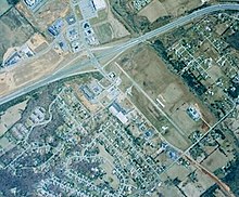
 The airstrip in 2002 | |||||||||||
| Summary | |||||||||||
| Airport type | Private | ||||||||||
| Owner | Norman C. Mayes | ||||||||||
| Serves | Knoxville, Tennessee | ||||||||||
| Location | Powell, Tennessee | ||||||||||
| Elevation AMSL | 992 ft / 302 m | ||||||||||
| Coordinates | 36°02′40″N 084°00′16″W | ||||||||||
| Map | |||||||||||
 9A2 Location of airport in Tennessee | |||||||||||
| Runways | |||||||||||
| |||||||||||
| Statistics (2000) | |||||||||||
| |||||||||||
The airport closed in the mid-2000s, and served its final flight in April 2012 when the then-owners sold the last aircraft that had been stored at the facility.[3] It is scheduled to become a shopping center based around a Kroger store.[4][5]
Facilities and aircraft
Powell STOLport covered an area of 30 acres (12 ha) at an elevation of 992 feet (302 m) above mean sea level. It had one runway designated 5/23 with an asphalt surface measuring 2,600 by 50 feet (792 x 15 m).[1]
For the 12-month period ending February 9, 2000, the airport had 1,375 general aviation aircraft operations, an average of 26 per week. At that time there were 5 aircraft based at this airport: 80% single-engine and 20% multi-engine.[1]
References
- FAA Airport Form 5010 for 9A2 PDF. Federal Aviation Administration. Effective July 31, 2008.
- "Archived copy". Archived from the original on 2015-05-07. Retrieved 2015-05-05.CS1 maint: archived copy as title (link)
- http://www.knoxnews.com/business/kroger-seeks-rezoning-for-powell-airport
- http://www.local8now.com/home/headlines/Airport-set-to-become-major-development-287836641.html
External links
- Aerial image as of March 2002 from USGS The National Map
- Aeronautical chart from SkyVector