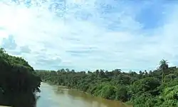
Paraopeba River
The Paraopeba River is a river in the state of Minas Gerais, Brazil. In the Tupi language "Para" means "great river or sea," and "peba" means "flat," together meaning "flat river".
| Paraopeba River | |
|---|---|
 Paraopeba River on the border of São Joaquim de Bicas and Betim. | |
| Location | |
| Country | Brazil |
| State | Minas Gerais |
| Physical characteristics | |
| Source | |
| • location | Cristiano Otoni |
| Mouth | |
• location | Três Marias Dam |
| Length | 510 km (320 mi) |
The source of the river is situated south of the municipality of Cristiano Otoni, Minas Gerais. The mouth is at the Três Marias Dam in the municipality of Felixlândia in the same state. The length of the river is 510 kilometres (320 mi) and its basin covers an area of 12,090 square kilometres (4,670 sq mi) and 35 municipalities. The most important tributaries are the Macaúba River, the Camapuã River and the Manso River (Minas Gerais). The Paraopeba River is one of the most important tributaries of the São Francisco River, ensuring the yearlong navigability of that river.[1]
On 25 January 2019, the Brumadinho dam collapsed, resulting in exceedingly high heavy mineral levels, with hundreds of times the nominal levels of copper. These high levels left 120 kilometers (75 mi) of the river ecosystem incredibly toxic, leading to it being called a "dead river". High levels of lead and chromium where also found in the 20 kilometers (12 mi) nearest to the collapse.[2]
See also
References
- Minas Gerais. Instituto Mineiro de Gestão das Águas (IGAM). Estudos das Metas De Qualidade Bacia Hidrográfica do Rio Paraopeba (2005). Disponível em: <"Archived copy" (PDF). Archived from the original (PDF) on 2007-08-04. Retrieved 2007-08-04.CS1 maint: archived copy as title (link)>. Acessado em 27 de setembro de 2008.
- "Ten towns hit by river pollution from Brazil dam disaster". France 24. 2019-02-13. Retrieved 2019-09-28.