Panwali Kantha Bugyal
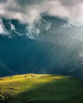
Panwali Kantha Bugyal is a Himalayan Alpine Meadow (commonly known as Bugyal) in the Tehri Garhwal district of Uttarakhand. Panwali Kantha Bugyal is a popular Trekking and Hiking Destination. The Bugyal has an average elevation of 3368m and is around 90 km from New Tehri. It is a lush green alpine meadow which has expanse of grass land. It has a well maintained trek route. The trek to Panwali Kantha Bugyal passes through lush vegetation of rhododendrons, oak and deodar forests.[1]
| Panwali Kantha Bugyal | |
|---|---|
 Panwali Kantha Bugyal | |
| Highest point | |
| Elevation | 3,368 m (11,050 ft) |
| Coordinates | 30.5659245°N 78.8641914°E |
| Geography | |
| Location | Tehri Garhwal, Uttarakhand, India |
| Parent range | Garhwal Himalaya |
There is a lush green grass all over the meadow during the monsoons. The trail is decked with red and pink rhododendron, during months of April and May. [2] During the winter season, the whole meadow is covered with snow. This place offers scenic views of the Char Dham ranges.[3] The trek starts from Uttarkashi at Gangotri's side and from Trijuginarayan at Kedarnath's side.[4] It is also accessible from Ghuttu Village which is about 30 km from Ghansali.
References
- "Panwali Kantha Bugyal". Tehri.nic.in.
- "Panwali Kantha Trek". indiahikes.com.
- "Panwali Kantha Trek". euttaranchal.com.
- "Panwali Kantha Trek". harkidun.org.