Oike Street
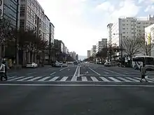
Oike Street (御池通 おいけどおり Oike Dōri[1]) is a mayor street that crosses the center of the city of Kyoto from east to west, running approximately 4.9 km from Kawabata Street (east) to Tenjingawa Street (west).[1]

History
During the period of the Heian-kyō, it was a narrow street known as Sanjō Bonmon Koji (三条坊門小路).[2] From the mid Edo period the street began to be known as Oike, due to the fact that in the past it passed by a large pond (池 ike) contained inside the then larger Shinsenen.[2] In 1945 during WW2, in the section between the west side of the Kamo River and Horikawa Street, houses and buildings were removed to create a firewall, making the street considerably wider. After 1947, due to the urban planning policy of the city, it was decided to maintain a width of 50 meters for this section.[2]
Present Day

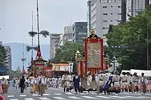
Nowadays the section between Kawabata Street and Horikawa Street is the widest street in the city of Kyoto.[1] This section is on the route of the Yamaboko Junkō parade of the Gion Matsuri and on the route of the parade of the Jidai Matsuri. Several subway stations of the Tōzai Line are located along this segment, as well as several relevant public facilities such as the Kyoto City Hall and Zest Oike, making it an important public space. For this reason, in the year 2003 after an extensive infrastructure improvement project, this section was designated as "Symbol Road" by the city of Kyoto.[3]
Relevant landmarks along the Street
- Kamo River
- Kyoto Hotel Okura
- Kyoto City Hall.
- Zest Oike
- Honnō-ji temple
- Hello Work Karasuma Oike Plaza
- Nichicon Corporation
- Nijō Castle
- Shinsenen Garden
- Shimadzu Corporation Sanjō Factory
Subway
References
- "御池通 京都通百科事典". www.kyototsuu.jp. Retrieved 2019-05-26.
- "京都市:御池通の概要". www.city.kyoto.lg.jp. Retrieved 2019-05-26.
- "京都市:御池通シンボルロード". www.city.kyoto.lg.jp. Retrieved 2019-05-26.