Ohio State Route 302
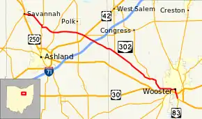
State Route 302 (SR 302) is an east-west (physically southeast-northwest) state highway in northeast Ohio, a U.S. state. State Route 302 has its eastern terminus at a signalized intersection with State Route 83 in the city of Wooster. The western terminus of the highway is at a T-intersection with the concurrency of U.S. Route 250 and State Route 60 in the village of Savannah.
| ||||
|---|---|---|---|---|
 | ||||
| Route information | ||||
| Maintained by ODOT | ||||
| Length | 28.47 mi[1] (45.82 km) | |||
| Existed | 1932[2][3]–present | |||
| Major junctions | ||||
| East end | ||||
| West end | ||||
| Location | ||||
| Counties | Wayne, Ashland | |||
| Highway system | ||||
| ||||
Route description
Along its way, State Route 302 travels through portions of Wayne and Ashland Counties. There is no part of this highway that is included within the National Highway System, a network of routes deemed most important for the nation's economy, mobility and defense.[4]
History
State Route 302 was designated in 1932. When it was established, State Route 302 was a spur route that started at its present intersection with Silver Road west of Wooster. At the time, U.S. Route 250 entered this intersection from the west along Silver Road, and departed to the southeast along present State Route 302. From there, State Route 302 ran along its present alignment northwest to the hamlet of Lattasburg, where it came to an end at its intersection with what is today the eastern terminus of State Route 301. In 1932, the intersecting roadway in Lattasburg was not a state route.[2][3] Three years after its inception, State Route 302 was extended to the northwest along its current alignment to a new western terminus at State Route 89 just south of Polk.[5][6] Then, in 1937, State Route 302 was extended again to the northwest, this time to its present western terminus at the U.S. Route 250/State Route 60 concurrency in Savannah.[7][8]
In 1938, State Route 302 was extended on the eastern end. When U.S. Route 250 was re-routed to join U.S. Route 30 further west of Wooster in the hamlet of Jefferson via County Road 157, State Route 302 was extended to the southeast to a new terminus at its present intersection with Old Lincoln Way just west of the Wooster city limits. Then, Old Lincoln Way was the routing of the concurrency of U.S. Route 30 and U.S. Route 250.[9] By 1964, a new southern bypass of Wooster opened, with U.S. Route 30 and U.S. Route 250 re-routed onto this new routing. Consequently, State Route 302 was extended to the east into downtown Wooster, where its new endpoint would be at the highway's present intersection with Market Street, which at the time was a part of State Route 76, the predecessor to today's State Route 83.[10][11] When the eastern freeway bypass of Wooster was extended south of the city's southern bypass in 1981 to link in directly with two-lane U.S. Route 250, State Route 83 was extended east along the former routing of U.S. Route 250 to the eastern bypass, where it then linked up with the U.S. highway heading north. Consequently, State Route 302 was then extended south over the former routing of State Route 83 from downtown Wooster south to its present eastern terminus, where State Route 83 re-joined its former alignment.[12][13]
Major intersections
| County | Location | mi[1] | km | Destinations | Notes |
|---|---|---|---|---|---|
| Wayne | Wooster | 0.00 | 0.00 | ||
| 0.93 | 1.50 | Interchange | |||
| Chester Township | 6.20 | 9.98 | Southern terminus of SR 539 | ||
| 12.90 | 20.76 | Southern terminus of SR 301 | |||
| Ashland | Jackson Township | 18.04 | 29.03 | ||
| 19.21 | 30.92 | ||||
| Orange Township | 22.77 | 36.64 | |||
| 24.82 | 39.94 | Southern end of SR 511 concurrency | |||
| 25.17 | 40.51 | Northern end of SR 511 concurrency | |||
| Savannah | 28.47 | 45.82 | |||
1.000 mi = 1.609 km; 1.000 km = 0.621 mi
| |||||
References
- Ohio Department of Transportation. "Technical Services Straight Line Diagrams". Retrieved 2009-06-19.
- Map of Ohio Showing State Highway System (MrSID) (Map). Cartography by ODOH. Ohio Department of Highways. 1931. Retrieved 2011-02-10.
- Map of Ohio Showing State Highway System (MrSID) (Map). Cartography by ODOH. Ohio Department of Highways. 1932. Retrieved 2011-02-10.
- National Highway System: Ohio (PDF) (Map). Federal Highway Administration. December 2003. Retrieved 2011-02-10.
- Map of Ohio Showing State Highway System (MrSID) (Map). Cartography by ODOH. Ohio Department of Highways. 1934. Retrieved 2011-02-10.
- Official Ohio Highway Map (MrSID) (Map). Cartography by ODOH. Ohio Department of Highways. 1935. Retrieved 2011-02-10.
- Official Ohio Highway Map (MrSID) (Map). Cartography by ODOH. Ohio Department of Highways. 1936. Retrieved 2011-02-10.
- Official Ohio Highway Map (MrSID) (Map). Cartography by ODOH. Ohio Department of Highways. 1937. Retrieved 2011-02-10.
- Official Ohio Highway Map (MrSID) (Map). Cartography by ODOH. Ohio Department of Highways. 1938. Retrieved 2011-02-10.
- Official Ohio Highway Map (MrSID) (Map). Cartography by ODOH. Ohio Department of Highways. 1962. Retrieved 2011-02-10.
- Official Ohio Highway Map (MrSID) (Map). Cartography by ODOH. Ohio Department of Highways. 1964. Retrieved 2011-02-10.
- Official Ohio Highway Map (MrSID) (Map). Cartography by ODOT. Ohio Department of Transportation. 1979. Retrieved 2011-02-10.
- Official Ohio Highway Map (MrSID) (Map). Cartography by ODOT. Ohio Department of Transportation. 1981. Retrieved 2011-02-10.
