North Dakota Highway 210
North Dakota Highway 210 (ND 210) is a 2.937-mile-long (4.727 km) east–west state highway in the U.S. state of North Dakota. It serves as a bypass of Wahpeton.
| ||||
|---|---|---|---|---|
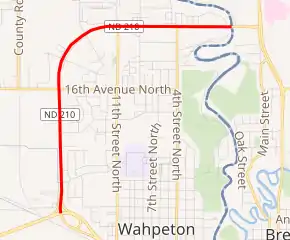
ND 210 highlighted in red | ||||
| Route information | ||||
| Maintained by NDDOT | ||||
| Length | 2.937 mi[1] (4.727 km) | |||
| Major junctions | ||||
| West end | ||||
| East end | ||||
| Location | ||||
| Counties | Richland | |||
| Highway system | ||||
| ||||
.svg.png.webp)
Route description
.jpg.webp)
ND 210 approaching its western terminus
The western terminus is located near Wahpeton, with Highway 13 traveling west and north of the city. Its eastern terminus is at the North Dakota – Minnesota border where the highway becomes MN 210 and continues east toward Duluth.
Major intersections
The entire route is in Richland County.
| Location | mi | km | Destinations | Notes | |
|---|---|---|---|---|---|
| Wahpeton | 0.000 | 0.000 | Interchange; western terminus | ||
| Red River | 2.937 | 4.727 | North Dakota–Minnesota line | ||
| Continuation into Minnesota | |||||
| 1.000 mi = 1.609 km; 1.000 km = 0.621 mi | |||||
Gallery
.jpg.webp)
Notes
- Mileage retrieved from North Dakota Highways 101 to 1806 Archived 2013-09-29 at the Wayback Machine unless otherwise noted.
This article is issued from Wikipedia. The text is licensed under Creative Commons - Attribution - Sharealike. Additional terms may apply for the media files.