National Register of Historic Places listings in Williams County, Ohio
This is a list of the National Register of Historic Places listings in Williams County, Ohio.

Location of Williams County in Ohio
It is intended to be a complete list of the properties and districts on the National Register of Historic Places in Williams County, Ohio, United States. The locations of National Register properties and districts for which the latitude and longitude coordinates are included below, may be seen in a Google map.[1]
There are 7 properties and districts listed on the National Register in the county.
- This National Park Service list is complete through NPS recent listings posted January 29, 2021.[2]
Current listings
| [3] | Name on the Register[4] | Image | Date listed[5] | Location | City or town | Description |
|---|---|---|---|---|---|---|
| 1 | Bryan Downtown Historic District |  Bryan Downtown Historic District |
December 29, 1983 (#83004347) |
Roughly bounded by Walnut, Beech, Maple, and Bryan Sts. 41°28′28″N 84°33′08″W |
Bryan | |
| 2 | Fountain City Historic District |  Fountain City Historic District |
October 1, 1990 (#90001501) |
Roughly bounded by Butler, Lynn, W. Wilson, Center, Portland, and Beech Sts. 41°28′16″N 84°33′12″W |
Bryan | |
| 3 | James Delos Hill House |  James Delos Hill House |
May 30, 1997 (#97000509) |
201 E. Main St. 41°35′12″N 84°36′20″W |
Montpelier | |
| 4 | Kunkle Log House | 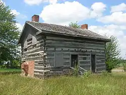 Kunkle Log House |
August 5, 1976 (#76001549) |
1 mile east of the junction of County Roads O and 17, near Kunkle 41°38′09″N 84°28′56″W |
Madison Township | |
| 5 | Nettle Lake Mound Group |  Nettle Lake Mound Group |
March 27, 1974 (#74001650) |
Eastern side of County Road 4-75, west of Nettle Lake[6] 41°41′15″N 84°43′53″W |
Northwest Township | |
| 6 | Stryker Depot | 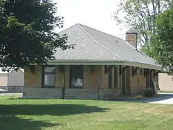 Stryker Depot |
August 7, 1989 (#89001014) |
N. Depot St. 41°30′10″N 84°25′01″W |
Stryker | |
| 7 | Williams County Courthouse |  Williams County Courthouse |
May 7, 1973 (#73001552) |
Main and High Sts. 41°28′26″N 84°33′45″W |
Bryan |
See also
| Wikimedia Commons has media related to National Register of Historic Places in Williams County, Ohio. |
References
- The latitude and longitude information provided in this table was derived originally from the National Register Information System, which has been found to be fairly accurate for about 99% of listings. Some locations in this table may have been corrected to current GPS standards.
- "National Register of Historic Places: Weekly List Actions". National Park Service, United States Department of the Interior. Retrieved on January 29, 2021.
- Numbers represent an alphabetical ordering by significant words. Various colorings, defined here, differentiate National Historic Landmarks and historic districts from other NRHP buildings, structures, sites or objects.
- "National Register Information System". National Register of Historic Places. National Park Service. April 24, 2008.
- The eight-digit number below each date is the number assigned to each location in the National Register Information System database, which can be viewed by clicking the number.
- Location derived from this Williams County Historical Society website; the NRIS lists it as "Address Restricted".
This article is issued from Wikipedia. The text is licensed under Creative Commons - Attribution - Sharealike. Additional terms may apply for the media files.