National Register of Historic Places listings in DeSoto County, Mississippi
This is a list of the National Register of Historic Places listings in DeSoto County, Mississippi.

Location of DeSoto County in Mississippi
This is intended to be a complete list of the properties and districts on the National Register of Historic Places in DeSoto County, Mississippi, United States. Latitude and longitude coordinates are provided for many National Register properties and districts; these locations may be seen together in a map.[1]
There are 12 properties and districts listed on the National Register in the county.
- This National Park Service list is complete through NPS recent listings posted January 29, 2021.[2]
Current listings
| [3] | Name on the Register | Image | Date listed[4] | Location | City or town | Description |
|---|---|---|---|---|---|---|
| 1 | Circle G Ranch | December 9, 2019 (#100004749) |
5921 Goodman Rd. W (MS 302 at intersection with MS 301) 34°57′45″N 90°05′42″W |
Horn Lake | ||
| 2 | Dockery House | August 25, 2004 (#04000901) |
3831 Robertson Gin Road 34°48′11″N 90°00′38″W |
Hernando | Constructed c. 1876 | |
| 3 | Hernando Commerce Street Historic District | August 30, 2001 (#01000918) |
Roughly along Commerce St., west of West St., S. 34°49′25″N 89°59′50″W |
Hernando | ||
| 4 | Hernando Courthouse Square District | 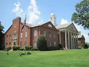 Hernando Courthouse Square District |
March 5, 1998 (#98000185) |
Roughly bounded by Caffey, W. Commerce, and Losher Sts., and U.S. Highway 51 34°49′23″N 89°59′41″W |
Hernando | |
| 5 | Hernando North Side Historic District | August 30, 2001 (#01000916) |
North of Holly Springs St., east of U.S. Route 51, west of Northview St., on W. Northern St., W. Valley St., Shady Ln., and Holly Springs St. 34°49′30″N 89°59′32″W |
Hernando | ||
| 6 | Hernando South Side (Magnolia) Historic District | August 30, 2001 (#01000917) |
Roughly bounded by Oak Grove Rd., Magnolia Dr., W. Center St., and Church St. 34°49′12″N 89°59′27″W |
Hernando | ||
| 7 | Hernando Water Tower |  Hernando Water Tower |
September 18, 2013 (#13000736) |
NE. corner of Losher & Church Sts. 34°49′22″N 89°59′32″W |
Hernando | |
| 8 | Felix Labauve House | March 29, 1978 (#78003074) |
2769 (formerly 235) Magnolia Drive 34°49′11″N 89°59′23″W |
Hernando | Constructed c. 1865 | |
| 9 | Miller Plantation House | July 15, 1982 (#82004630) |
Miller Road 34°55′28″N 89°46′45″W |
Olive Branch | Constructed c. 1849 | |
| 10 | North Elm Historic District | March 27, 2012 (#12000153) |
Roughly bounded by North, W. Robinson, & Memphis Sts., & Holmes Rd. 34°49′37″N 89°59′53″W |
Hernando | ||
| 11 | Robertson-Yates House | June 23, 2003 (#03000554) |
5000 Robertson Gin Road 34°47′10″N 90°01′23″W |
Hernando | Constructed c. 1850 | |
| 12 | Springhill Cemetery | July 25, 2012 (#12000430) |
College St. & W. Oak Grove Rd. 34°48′59″N 90°00′07″W |
Hernando |
See also
| Wikimedia Commons has media related to National Register of Historic Places in DeSoto County, Mississippi. |
References
- The latitude and longitude information provided in this table was derived originally from the National Register Information System, which has been found to be fairly accurate for about 99% of listings. Some locations in this table may have been corrected to current GPS standards.
- "National Register of Historic Places: Weekly List Actions". National Park Service, United States Department of the Interior. Retrieved on January 29, 2021.
- Numbers represent an alphabetical ordering by significant words. Various colorings, defined here, differentiate National Historic Landmarks and historic districts from other NRHP buildings, structures, sites or objects.
- The eight-digit number below each date is the number assigned to each location in the National Register Information System database, which can be viewed by clicking the number.
Municipalities and communities of DeSoto County, Mississippi, United States | ||
|---|---|---|
| Cities | Map of Mississippi highlighting DeSoto County | |
| Town | ||
| CDPs | ||
| Unincorporated communities | ||
| Former community | ||
| ||
| Topics | |
|---|---|
| Lists by state |
|
| Lists by insular areas | |
| Lists by associated state | |
| Other areas | |
| Related | |
| |
This article is issued from Wikipedia. The text is licensed under Creative Commons - Attribution - Sharealike. Additional terms may apply for the media files.