National Register of Historic Places listings in Colleton County, South Carolina
This is a list of the National Register of Historic Places listings in Colleton County, South Carolina.

Location of Colleton County in South Carolina
This is intended to be a complete list of the properties and districts on the National Register of Historic Places in Colleton County, South Carolina, United States. The locations of National Register properties and districts for which the latitude and longitude coordinates are included below, may be seen in a map.[1]
There are 11 properties and districts listed on the National Register in the county.
- This National Park Service list is complete through NPS recent listings posted January 29, 2021.[2]
Current listings
| [3] | Name on the Register[4] | Image | Date listed[5] | Location | City or town | Description |
|---|---|---|---|---|---|---|
| 1 | Colleton County Courthouse | 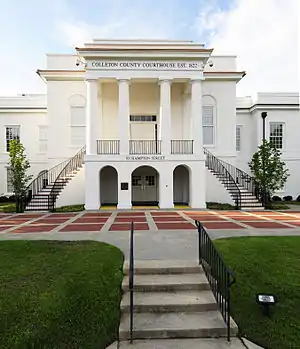 Colleton County Courthouse |
May 14, 1971 (#71000765) |
Corner of Hampton and Jeffries Sts. 32°54′09″N 80°40′00″W |
Walterboro | |
| 2 | Hickory Valley Historic District |  Hickory Valley Historic District |
November 21, 1980 (#80003666) |
Roughly bounded by Ireland Creek, Jeffries Boulevard, and Wichman, Verdier, and Ivanhoe Sts. 32°54′26″N 80°39′42″W |
Walterboro | |
| 3 | Hotel Albert Commercial Block |  Hotel Albert Commercial Block |
March 25, 1999 (#99000395) |
529, 539, and 545 E. Washington St. 32°54′18″N 80°39′47″W |
Walterboro | |
| 4 | Old Colleton County Jail | 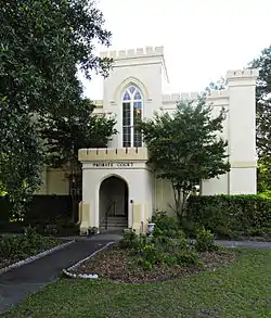 Old Colleton County Jail |
May 14, 1971 (#71000766) |
Jeffries Boulevard 32°54′25″N 80°39′20″W |
Walterboro | |
| 5 | Pon Pon Chapel |  Pon Pon Chapel |
January 5, 1972 (#72001205) |
Northwest of Jacksonboro on Parker's Ferry Rd. 32°48′30″N 80°29′33″W |
Jacksonboro | |
| 6 | Ravenwood Plantation |  Ravenwood Plantation |
May 1, 1997 (#97000359) |
South Carolina Highway 64, 0.9 miles east of South Carolina Highway 458 32°49′42″N 80°34′41″W |
Neyles | |
| 7 | St. James the Greater Catholic Mission |  St. James the Greater Catholic Mission |
September 29, 2015 (#15000676) |
3087 Ritter Rd. 32°46′36″N 80°39′44″W |
Walterboro | |
| 8 | Spanish Mount Point | _from_boardwalk.JPG.webp) Spanish Mount Point |
August 30, 1974 (#74001836) |
Edisto Beach State Park[6] 32°29′57″N 80°19′13″W |
Edisto Island | |
| 9 | Walterboro Historic District | 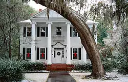 Walterboro Historic District |
November 10, 1980 (#80003667) |
Roughly bounded by Jeffries Boulevard and Sanders, Black, Church, Valley, and Lemacks Sts.; also 807 Hampton St. 32°54′05″N 80°38′40″W |
Walterboro | 807 Hampton represents a boundary increase of June 3, 1993 |
| 10 | Walterboro Library Society Building | .jpg.webp) Walterboro Library Society Building |
October 14, 1971 (#71000767) |
801 Wichman St. 32°54′12″N 80°39′08″W |
Walterboro | |
| 11 | Tom Williams House | April 26, 1973 (#73001706) |
0.25 miles west of Williams on South Carolina Highway 362 33°02′16″N 80°51′14″W |
Williams |
See also
| Wikimedia Commons has media related to National Register of Historic Places in Colleton County, South Carolina. |
References
- The latitude and longitude information provided in this table was derived originally from the National Register Information System, which has been found to be fairly accurate for about 99% of listings. Some locations in this table may have been corrected to current GPS standards.
- "National Register of Historic Places: Weekly List Actions". National Park Service, United States Department of the Interior. Retrieved on January 29, 2021.
- Numbers represent an alphabetical ordering by significant words. Various colorings, defined here, differentiate National Historic Landmarks and historic districts from other NRHP buildings, structures, sites or objects.
- "National Register Information System". National Register of Historic Places. National Park Service. March 13, 2009.
- The eight-digit number below each date is the number assigned to each location in the National Register Information System database, which can be viewed by clicking the number.
- "Things to Do at Edisto Beach State Park". South Carolina Parks. Retrieved 2013-01-13.
| Topics |  | |
|---|---|---|
| Lists by county |
| |
| Lists by city |
| |
| Other lists | ||
Municipalities and communities of Colleton County, South Carolina, United States | ||
|---|---|---|
| City | Map of South Carolina highlighting Colleton County | |
| Towns | ||
| CDPs | ||
| Unincorporated communities | ||
| ||
This article is issued from Wikipedia. The text is licensed under Creative Commons - Attribution - Sharealike. Additional terms may apply for the media files.