Mynydd Cambergi
Mynydd Cambergi or Mynydd Cam-bergi is a mountain in southern Snowdonia, Wales. It is a summit on a long ridge between Mynydd y Waun to the north and Foel Grochan to the east. The mountain forms the north-east side of Cwm Hengae and sits about 0.5 miles (0.80 km) west of the village of Aberangell.
| Mynydd Cambergi | |
|---|---|
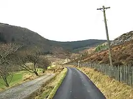
 Looking west along Cwm Hengae, with the lower slopes of Mynydd Cambergi on the right | |
| Highest point | |
| Elevation | 449 m (1,473 ft) [1] |
| Naming | |
| Language of name | Welsh |
| Geography | |
| Location | Gwynedd, UK |
| Parent range | Snowdonia |
| OS grid | SH 767111 |
Near the summit of the mountain lies the open pit of Cambergi quarry, which was worked from the 1870s to the 1890s.[2]
References
- Merionethshire XLII.NE (Map). Ordnance Survey. 1900. Retrieved 9 September 2019.
- Richards, Alun John (1994). Slate Quarrying at Corris. Gwasg Carreg Gwalch. ISBN 0-86381-279-1.
This article is issued from Wikipedia. The text is licensed under Creative Commons - Attribution - Sharealike. Additional terms may apply for the media files.