Military Tract of 1812
On May 6, 1812 Congress passed Act of Congress 2 Statutes at Large 729 (2 Stat. 729), setting aside bounty lands as payment to volunteer soldiers for the War against the British (War of 1812).[1] The land was set aside in western territories that became part of the present states of Arkansas, Michigan and Illinois.

However, lands in Missouri were later substituted for those in Michigan, due to a report by the surveyor-general of the United States, Edward Tiffin, which quite misleadingly described the land in Michigan that had been set aside for this purpose as undesirable. Other later acts of Congress, until 1855, continued to address the needs of soldiers wishing to redeem their bounty land warrants and efforts continued to try to provide suitable land area for these soldiers.
Bounty lands
The term bounty land is somewhat self-explanatory. Tracts of land were given outright by the states, and later by the federal government as partial compensation (or "bounty") for service in times of military conflict. Such bounty was also occasionally used by the government to incite men to serve in war or conflicts. Bounty land warrants were issued from the colonial period until 1858, when the program was discontinued, and five years later, in 1863, the rights to locate and take possession of bounty lands ceased.
Military land bounties were offered by the United States Government in the early national period to attract men into the Army or to reward soldiers for their services. Warrants were issued to the men for these bounties.
The great bulk of early bounty land at the time of the Revolution was in Virginia, as it existed in colonial times. Since Virginia provided the great bulk of fighting men in the Revolution, the first bounty lands were to be located between the Mississippi, Ohio and Green Rivers in what is now Kentucky. However, this area did not provide enough land, and the Virginia Military Tract was established, which was in what is now the state of Ohio. Continental Army soldiers from Virginia were the only group allowed to settle in the Ohio area, while state soldiers were to use the lands in Kentucky. The United States Military District was a 2,500,000-acre (10,000 km2) tract in eastern Ohio established by the Federal Government in 1796 for bounties to soldiers from other states.
Illinois Military Tract of 1812

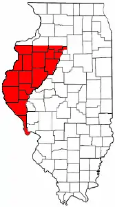
One of the three districts (or "tracts") created to meet the warrants given in the War of 1812, "The Tract" was within a triangle of the Illinois Territory between the Mississippi and Illinois Rivers. This area was included with Illinois' territory upon the achievement of statehood in 1818.
The Southern Boundary is the confluence of the Illinois and Mississippi rivers, near Grafton, approximately 25 miles (40 km) northwest of downtown St. Louis, MO and about 20 miles (32 km) upstream from the confluence of the Missouri River and the Mississippi at Hartford.
The Northern Boundary, is a line 90 miles (144.8 km) north of the Base Line (also known as the Beardstown Baseline) which was established with the Fourth Principal Meridian in 1815. This northern boundary line begins 6 miles (10 km) south of downtown Muscatine, IA at the Mississippi River and extends for 90 miles (144 km) East to the Illinois River near Hennepin in Putnam County. The Tract’s northern boundary line forms the southern border line of Rock Island County.
The Illinois tract, surveyed in 1815-1816, contained more than 5,000,000 acres (20,000 km²), of which 3,500,000 acres (14,000 km²) were deemed fit for cultivation and set aside for military bounties. Comprising 207 entire townships, each six miles (10 km) square, and 61 fractional townships, the tract included present Illinois counties of Adams, Brown, Calhoun, Fulton, Hancock, Henderson, Knox, McDonough, Mercer, Peoria, Pike, Schuyler, Stark, and Warren Counties.
It also includes part of Henry and Bureau Counties, and those parts of Marshall and Putnam which are on the west side of the Illinois River.
Soldiers of the War of 1812, who received 160 acres (0.6 km2) each, were required to locate their warrants by lottery. Most soldiers or their heirs decided, however, against moving great distances to take up their claims. Instead, they sold their warrants to speculators. One company alone acquired 900,000 acres (3,600 km²). Such large-scale land holdings aroused frontier hostility against absentee speculators. Squatters settled upon the lands, ignoring titles and rights. Many speculators were unable to realize a quick profit and, faced with ever-increasing taxation, lost their titles or sold their lands at a loss of money.
The tract was surveyed in 1815–1816 and opened to settlement. Then warrants for land were issued by the government. Many of these land grants can be found by searching Illinois Public Land Sales. For an explanation of the way the land in these grants are surveyed, see Public Land Survey System.
The General Land Office issued over 17,000 patents in the Illinois Military Tract between October 1817 and January 1819. No one has determined the number of War of 1812 veterans who actually moved to their free land in the Illinois, Arkansas or Missouri military tracts. Over 60% of these patents were issued in the Illinois Military Tract.
After the organization of the Illinois state government in 1818, the state began to sell these lands for taxes, and for a considerable period the principal revenue of the state was derived from this source. The greater portion of these lands thus went into possession of parties who held them under these tax titles. The grantees of the soldiers, who were the original patentees, brought suit for ejectment and much of the court business of pioneer days was given over to tax titles. Final adjustment of the claims was made only after years of litigation, a supreme court decision (1859) and much legislation.
The white population of Illinois exploded after the War of 1812, exceeding 50,000 in 1820 and 150,000 in 1830. In 1828, the U.S. government liaison, Thomas Forsyth, informed the native Indian tribes that they should begin vacating their settlements east of the Mississippi.
The Black Hawk War of 1832 resulted in the deaths of 70 settlers and soldiers, and hundreds of Black Hawk's band. The war not only affected the lives of the Indians, settlers, and militiamen involved, but also the settlements of Illinois, Iowa, and Wisconsin. The Black Hawk War was responsible for the end of conflict between settlers and Indians in these states. After the Black Hawk War settlement was further retarded by conflicting land claims. The newspaper Illinois Bounty Land Register, first published in 1835, to advertise lands granted to veterans, is one of the ancestors of the current Quincy Herald-Whig newspaper.
The Archives and Special Collections Unit at Western Illinois University Libraries is the primary public archive for information relating to the history and development of the Illinois Military Tract.
See also
- Land grant
- List of principal and guide meridians and base lines of the United States
- Fourth principal meridian, as known as Beardstown baseline
- Fort Johnson
References
- Prechtel-Kuskens, Claire (January 2011), "Researching volunteer soldiers of the War of 1812" (PDF), National Genealogical Society, Washington, D.C., pp. 36–41
- An Act to provide for designating, surveying and granting the Military Bounty Lands, Act of the 12th United States Congress, Session I, Chapter 77, May 6, 1812
- An Act to authorize the survey of two million acres (8,000 km²) of the public lands, in lieu of that quantity heretofore authorized to be surveyed, in the territory of Michigan, as military bounty lands, Act of the 14th United States Congress, Session I, Chapter 164, April 19, 1816
- Description of the military land in Michigan, report by surveyor-general Edward Tiffin, November 30, 1815, in Michigan As a Province, Territory and State, the Twenty-Sixth Member of the Federal Union Vol. 2, by Henry M. Utley and Clarence M. Cutcheon. pg. 254-255.
- The History of McDonough County, Illinois compiled by R. Chenoweth and S.W. Semonis, sponsored by the McDonough Co. Genealogical Society, 1992, Curtis Media Corporation, Dallas, TX.
- https://web.archive.org/web/20070927175101/http://www.historyillinois.org/Markers/old_markers/224.htm Illinois State Historical Society, IL Military Tract, Henry County
- http://webarchive.loc.gov/all/20011109042401/http://users.arn.net/~billco/uslpr4.htm
- MAXWELL v. MOORE, 63 U.S. Supreme Court 185 (1859)
- Black Hawk war at Northern Illinois University
- Quincy Herald-Whig
- Western Illinois University Archives and Special Collections