Mexico tropical cyclone rainfall climatology
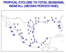
Mexico tropical cyclone rainfall climatology discusses precipitation characteristics of tropical cyclones that have struck Mexico over the years. One-third of the annual rainfall received along the Mexican Riviera and up to half of the rainfall received in Baja California Sur is directly attributable to tropical cyclones moving up the west coast of Mexico. The central plateau is shielded from the high rainfall amounts seen on the oceanward slopes of the Sierra Madre Oriental and Occidental mountain chains.

General characteristics

Storms track near and along the western Mexican coastline primarily between the months of July and September.[1] These storms enhance the monsoon circulation over northwest Mexico and the southwest United States.[2] On an average basis, eastern Pacific tropical cyclones contribute about one-third of the annual rainfall along the Mexican Riviera, and up to one-half of the rainfall seen annually across Baja California Sur.[3] Mexico is twice as likely (18% of the basin total) to be impacted by a Pacific tropical cyclone on its west coast than an Atlantic tropical cyclone on its east coast (9% of the basin total). The three most struck states in Mexico in the 50 years at the end of the 20th century were Baja California Sur, Sinaloa, and Quintana Roo.[4]
Highest known rainfall amounts

Below is a list of the top ten highest known storm total rainfall amounts from individual tropical cyclones across Mexico. Most of the rainfall information was provided by the Mexico's National Weather Service, Servicio Meteorológico Nacional, which is a part of the National Water Commission, Comisión Nacional del Agua.
| Precipitation | Storm | Location | Ref. | ||
|---|---|---|---|---|---|
| Rank | mm | in | |||
| 1 | 1576 | 62.05 | Wilma 2005 | Quintana Roo | [5] |
| 2 | 1119 | 44.06 | Frances 1998 | Escuintla | [6] |
| 3 | 1098 | 43.23 | TD 11 (1999) | Jalacingo | [7] |
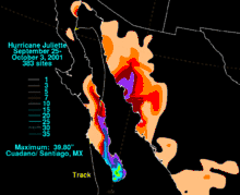
| 4 | 1011 | 39.80 | Juliette 2001 | Cuadano/Santiago | [8] |
| 5 | 950 | 37.41 | Dolly 1996 | Igual | [9] |
| 6 | 941 | 37.06 | Fifi–Orlene 1974 | Tlanchinol | [10] |
| 7 | 890 | 35.04 | Alex 2010 | Monterrey | [11] |
| 8 | 805 | 31.69 | Gert 1993 | Aquismón | [12] |
| 9 | 791 | 31.15 | Hermine 1980 | San Pedro Tapanatepec | [13] |
| 10 | 774 | 30.49 | Isidore 2002 | Campeche | [14] |
Maximum tropical cyclone rainfall per state for Mexico

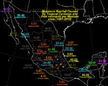
On the western side of Mexico, the Sierra Madre Occidental keeps the central plateau free of excessive rainfall, as tropical cyclones originating in the Eastern Pacific Ocean rain themselves out on the upslope sides of the topography. On the eastern side of Mexico, the Sierra Madre Oriental has the same orographic effect, this time blocking tropical disturbances making landfall from the Gulf of Mexico. State maxima relating to tropical cyclones and their remnants are shown on the right, color-coded by amount.
See also
References
- D. S. Gutzler, E. A. Ritchie, A. V. Douglas, and M. D. Lewis. Interannual Variability of Near-Coastal Eastern Pacific Tropical Cyclones. Retrieved on 2007-06-21.
- R. W. Higgins and W. Shi. Relationships Between Gulf of California Moisture Surges and Tropical Cyclones in the Eastern Pacific Basin. Archived 2008-10-22 at the Wayback Machine Retrieved on 2007-06-21.
- Art Douglas and Phil Englehart. An Historical Analysis of Transient Rain Bearing Systems in the NAME Domain: The Impact of Inverted Troughs on Monsoon Rainfall. Archived 2006-10-05 at the Wayback Machine Retrieved on 2007-06-21.
- E. Jáuregui. Climatology of landfalling hurricanes and tropical storms in Mexico. Archived 2007-12-01 at the Wayback Machine Retrieved on 2007-06-23.
- Roth, David M. "Maximum Rainfall Caused By Tropical Cyclones and their remnants per Mexican state (1981-2010)". Hydrometeorological Prediction Center: Tropical Cyclone Point Maxima. National Oceanic and Atmospheric Administration. Retrieved 2012-09-10.
- Roth, David M. "Tropical Storm Frances (1998) Rainfall Graphic". Tropical Cyclone Point Maxima (GIF). Hydrometeorological Prediction Center. National Oceanic and Atmospheric Administration. Retrieved 2012-09-10.
- Roth, David M. "Tropical Depression Eleven (1999) Rainfall Graphic". Tropical Cyclone Point Maxima (GIF). Hydrometeorological Prediction Center. National Oceanic and Atmospheric Administration. Retrieved 2012-09-10.
- Roth, David M. "Hurricane Juliette (2001) Rainfall Graphic". Tropical Cyclone Point Maxima (GIF). Hydrometeorological Prediction Center. National Oceanic and Atmospheric Administration. Retrieved 2012-06-08.
- Roth, David M. "Hurricane Dolly (1996) Rainfall Graphic". Tropical Cyclone Point Maxima (GIF). Hydrometeorological Prediction Center. National Oceanic and Atmospheric Administration. Retrieved 2012-09-10.
- Roth, David M. "Hurricane Fifi/Orlene (1974) Rainfall Graphic". Tropical Cyclone Point Maxima (GIF). Hydrometeorological Prediction Center. National Oceanic and Atmospheric Administration. Retrieved 2012-09-10.
- Roth, David M. "Hurricane Alex (2010) Rainfall Graphic". Tropical Cyclone Point Maxima (GIF). Hydrometeorological Prediction Center. National Oceanic and Atmospheric Administration. Retrieved 2012-09-10.
- Roth, David M. "Hurricane Gert (1993) Rainfall Graphic". Tropical Cyclone Point Maxima (GIF). Hydrometeorological Prediction Center. National Oceanic and Atmospheric Administration. Retrieved 2012-09-10.
- Roth, David M. "Tropical Storm Hermine (1980) Rainfall Graphic". Tropical Cyclone Point Maxima (GIF). Hydrometeorological Prediction Center. National Oceanic and Atmospheric Administration. Retrieved 2012-06-08.
- Roth, David M. "Hurricane Isidore (2002) Rainfall Graphic". Tropical Cyclone Point Maxima (GIF). Hydrometeorological Prediction Center. National Oceanic and Atmospheric Administration. Retrieved 2012-09-10.
- David Roth. "Tropical Cyclone Maxima Per Mexican State" (GIF). Tropical Cyclone Rainfall Data. Hydrometeorological Prediction Center. Retrieved 2007-07-21.