Maryland Route 760
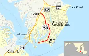
Maryland Route 760 (MD 760) is a state highway in the U.S. state of Maryland. Known as Rousby Hall Road, the state highway runs 4.56 miles (7.34 km) from Rousby Road in Drum Point north to MD 2 and MD 4 in Lusby. The portion of MD 760 in Lusby was built as MD 503 in the early 1930s; the Drum Point section was constructed as a county highway by 1939. MD 503 was removed from the state highway system in the late 1950s. MD 760 was designated in two sections in the early 1960s.
| ||||
|---|---|---|---|---|
| Rousby Hall Road | ||||
 | ||||
| Route information | ||||
| Maintained by MDSHA | ||||
| Length | 4.56 mi[1] (7.34 km) | |||
| Existed | 1962–present | |||
| Major junctions | ||||
| South end | Rousby Road in Drum Point | |||
| North end | ||||
| Location | ||||
| Counties | Calvert | |||
| Highway system | ||||
| ||||
Route description
_at_Olivet_Road_and_Southern_Connector_Boulevard_in_Lusby%252C_Calvert_County%252C_Maryland.jpg.webp)
MD 760 begins at Rousby Road on a peninsula adjacent to Solomons Island and the mouth of the Patuxent River. The state highway heads east and then northeast as a two-lane undivided road through the community of Drum Point. MD 760 curves north as it passes along the western edge of Chesapeake Ranch Estates and crosses Coles Creek. The state highway turns west and crosses Mill Creek into Lusby, where the highway meets Olivet Road and Southern Connector Boulevard at a roundabout, from which MD 760 continues north. MD 760 intersects MD 765 (H.G. Trueman Road) in a commercial area before reaching its northern terminus at a directional crossover intersection with MD 2 and MD 4, which run concurrently as Solomons Island Road.[1][2]
History
MD 760's predecessor state highway was MD 503, which was assigned to the highway from MD 2 (now MD 765) in Lusby to the southern end of Olivet Road in community of Olivet on the peninsula between St. John Creek and Mill Creek.[3] The portion of MD 760 in Drum Point was preceded by a series of streets, now part of residential subdivisions, that connected Lusby with the Drum Point Light.[4] MD 503 was constructed as a gravel road in 1933.[5][6] The Drum Point portion of MD 760 was constructed as a county highway by 1938 to provide access to the M.M. Davis Shipyard, a leading producer of yachts that was sited on Ship Point opposite Solomons at the mouth of Mill Creek in 1913.[7][8] The road to the Davis Shipyard and the portion of MD 503 north to MD 2 was improved as a wartime access project in around 1944.[9] MD 503 was removed from the state highway system in 1957.[10] MD 760 was assigned in two sections: along Rousby Hall Road from the present southern terminus to Olivet Road in 1962, and from there north to MD 2 in 1963.[11][12] The state highway was extended north to MD 2 and MD 4 when the two highways were relocated from MD 765 to a new divided highway to the west around 1987; this intersection was changed to a directional crossover intersection in 2005.[13][14] The roundabout at Olivet Road was constructed in 2006 in conjunction with the fourth leg of the roundabout, Southern Connector Boulevard.[15]
Junction list
The entire route is in Calvert County.
| Location | mi[1] | km | Destinations | Notes | |
|---|---|---|---|---|---|
| Drum Point | 0.00 | 0.00 | Rousby Road west | Southern terminus | |
| Lusby | 3.17 | 5.10 | Olivet Road south / Southern Connector Boulevard west | Roundabout | |
| 4.38 | 7.05 | Officially MD 765Q | |||
| 4.65 | 7.48 | Northern terminus | |||
| 1.000 mi = 1.609 km; 1.000 km = 0.621 mi | |||||
See also
 Maryland Roads portal
References
- Highway Information Services Division (December 31, 2013). Highway Location Reference. Maryland State Highway Administration. Retrieved 2011-02-18.
- Calvert County (PDF).
- Google (2010-08-03). "Maryland Route 760" (Map). Google Maps. Google. Retrieved 2010-08-03.
- Maryland State Roads Commission (1939). General Highway Map: State of Maryland (Map). Baltimore: Maryland State Roads Commission.
- Drum Point, MD quadrangle (Map) (1905 ed.). 1:48,000. 15 Minute Series (Topographic). United States Geological Survey. Retrieved 2011-02-21.
- Byron, William D.; Lacy, Robert (December 28, 1934). Report of the State Roads Commission of Maryland (1931–1934 ed.). Baltimore: Maryland State Roads Commission. p. 322. Retrieved 2011-02-21.
- Maryland Geological Survey (1933). Map of Maryland Showing State Road System: State Aid Roads and Improved County Road Connections (Map). Baltimore: Maryland Geological Survey.
- Beall, J. Glenn; Jarboe, Elmer R.; Obrecht, George F., Sr. (March 4, 1939). Report of the State Roads Commission of Maryland (1937–1938 ed.). Baltimore: Maryland State Roads Commission. p. 24. Retrieved 2011-02-23.
- Robby, F. (2007-11-11). "M.M. Davis Shipyard Marker". The Historical Marker Database. Springfield, VA: J.J. Prats. Retrieved 2011-02-21.
- Whitman, Ezra B.; Webb, P. Watson; Thomas, W. Frank (March 1, 1945). Report of the State Roads Commission of Maryland (1943–1944 ed.). Baltimore: Maryland State Roads Commission. p. 95. Retrieved 2011-02-21.
- Maryland State Roads Commission (1957). Maryland: Official Highway Map (Map). Baltimore: Maryland State Roads Commission.
- Maryland State Roads Commission (1962). Maryland: Official Highway Map (Map). Baltimore: Maryland State Roads Commission.
- Maryland State Roads Commission (1963). Maryland: Official Highway Map (Map). Baltimore: Maryland State Roads Commission.
- Maryland State Highway Administration (1987). Maryland: Official Highway Map (Map). Baltimore: Maryland State Highway Administration.
- Highway Information Services Division (December 31, 2005). Highway Location Reference. Maryland State Highway Administration. Retrieved 2011-02-21.
- Calvert County (PDF).
- Highway Information Services Division (December 31, 2006). Highway Location Reference. Maryland State Highway Administration. Retrieved 2011-02-21.
- Calvert County (PDF).
