Martigny River
The Martigny River is a tributary of the Turgeon River, flowing into the Municipality of Eeyou Istchee James Bay (municipality), in Jamésie, in the administrative region from Nord-du-Québec, in Quebec, in Canada. The course of the river crosses the townships of Martigny, Martinière and Lanouillier.
| Martigny | |
|---|---|
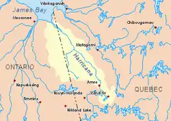
 Harricana River basin in yellow | |
| Location | |
| Country | Canada |
| Province | Quebec |
| Region | Eeyou Istchee Baie-James (municipality) |
| Physical characteristics | |
| Source | Lac aux Épices |
| • location | Eeyou Istchee Baie-James (municipality), Nord-du-Québec, Quebec |
| • coordinates | 50°07′47″N 79°11′42″W |
| • elevation | 241 m (791 ft) |
| Mouth | Turgeon River |
• location | Eeyou Istchee Baie-James, Quebec |
• coordinates | 49°59′20″N 79°00′50″W |
• elevation | 235 m (771 ft) |
| Length | 30.2 km (18.8 mi)[1] |
| Basin features | |
| Tributaries | |
| • right | Discharge of Lemoyne Lake. |
This hydrographic slope is covered by several marsh areas. The surface of the river is usually frozen from early November to mid-May, however, safe ice movement is generally from mid-November to the end of April.
Geography
The main hydrographic slopes near the Martigny River are:
- North side: Harricana River, Breynat River, Mannerelle River, Malouin River;
- East side: Harricana River, Samson River (Baie-James);
- South side: Turgeon River, Wawagosic River;
- West side: Turgeon River, Detour River.
The Martigny River derives its source from "Lac aux Épices" (length: 3.9 kilometres (2.4 mi), altitude: 241 metres (791 ft)), located in the township of Martigny, in the municipality of Eeyou Istchee James Bay (municipality).
The mouth of "Lac aux Épices" is located at:
- 20.7 kilometres (12.9 mi) Northwest of Martigny River mouth (confluence with Turgeon River);
- 103.6 kilometres (64.4 mi) Southeast of the mouth of Harricana River;
- 23.3 kilometres (14.5 mi) Northwest of the mouth of the Turgeon River;
- 23.0 kilometres (14.3 mi) East of the Ontario border.
From the source, the Martigny River flows over 30.2 kilometres (18.8 mi) according to the following segments:
- 4.3 kilometres (2.7 mi) Southeast, to the outlet (coming from the south) of a group of lakes, notably Lemoyne, Laforge and Bouchard;
- 6.0 kilometres (3.7 mi) Southeasterly to the west shore of Lac Martigny;
- 4.6 kilometres (2.9 mi) Southeast across Lake Martigny (length: 5.7 kilometres (3.5 mi); altitude: 242 metres (794 ft)), up to mouth;
- 8.4 kilometres (5.2 mi) Southeast across Finger Lake (length: 2.5 kilometres (1.6 mi); altitude: 242 metres (794 ft)), up to its mouth;
- 6.9 kilometres (4.3 mi) Southeasterly to mouth[2]
The Martigny River flows on the north shore of the Turgeon River, to:
- 6.0 kilometres (3.7 mi) Southwest of the mouth of the Turgeon River;
South of the mouth of the Harricana River
Toponymy
The term "Martigny" is a surname of French origin.
The toponym "rivière Martigny" was formalized on December 5, 1968, at the Commission de toponymie du Québec, when it was founded.[3]
Notes and references
- Atlas of Canada
- Distances from the Department of Natural Resources Canada's Atlas of Canada (published on the Internet).
- Commission de toponymie du Quebec - Bank of place names - Toponym: "Martigny river"
See also
- Eeyou Istchee Baie-James (municipality), a municipality
- Jamésie, a region
- Turgeon River, a watercourse
- Harricana River, a watercourse
- James Bay, a body of water
- List of rivers of Quebec