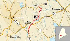
Maine State Route 134
State Route 134 (abbreviated SR 134) is a north-south route in the U.S. State of Maine that connects SR 41 and its southern points, such as Winthrop, with SR 43 and its northern points, such as Anson. SR 134 intersects U.S. Route 2 (US 2) and SR 27 in the town of New Sharon.[2] Before circa 1946, it was known as SR 41, while the current SR 41 was known as SR 134.
| ||||
|---|---|---|---|---|
 | ||||
| Route information | ||||
| Maintained by MaineDOT | ||||
| Length | 12.53 mi[1] (20.17 km) | |||
| Major junctions | ||||
| South end | ||||
| North end | ||||
| Highway system | ||||
| ||||
Major intersections
| County | Location[3] | mi[1] | km | Destinations | Notes |
|---|---|---|---|---|---|
| Franklin | New Sharon | 0.00 | 0.00 | ||
| 3.89 | 6.26 | Southern end of concurrency with US 2 / SR 27 | |||
| 4.10 | 6.60 | Northern end of concurrency with US 2 / SR 27 | |||
| Somerset | Starks | 12.53 | 20.17 | ||
1.000 mi = 1.609 km; 1.000 km = 0.621 mi
| |||||
References
- Maine DOT Map Viewer (Map). Maine Office of GIS. Retrieved October 14, 2017.
- Google (August 18, 2016). "Driving Directions" (Map). Google Maps. Google. Retrieved August 18, 2016.
- DeLorme (2011). "Map 20" (Map). The Maine Atlas and Gazetteer (32nd ed.). Yarmouth, ME: DeLorme.
This article is issued from Wikipedia. The text is licensed under Creative Commons - Attribution - Sharealike. Additional terms may apply for the media files.
