M-217 (Michigan highway)
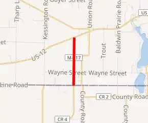
M-217, also known as Michiana Parkway, is a multi-lane state trunkline highway in the U.S. state of Michigan. The Michiana Parkway, which extends into Indiana, was constructed as a joint effort of the Michigan Department of Transportation (MDOT), the Cass County Road Commission and the Elkhart County Highway Department. Michigan's segment of the parkway is 1.563 miles (2.515 km) long continuing County Road 17 (CR 17) in Elkhart County north into the state.
| ||||
|---|---|---|---|---|
| Michiana Parkway | ||||

M-217 highlighted in red | ||||
| Route information | ||||
| Maintained by MDOT | ||||
| Length | 1.653 mi[1] (2.660 km) | |||
| Existed | September 25, 2002[2]–present | |||
| Major junctions | ||||
| South end | ||||
| North end | ||||
| Location | ||||
| Counties | Cass | |||
| Highway system | ||||
| ||||
Route description
M-217 starts at State Line Road on the Michigan–Indiana state line. It is the continuation of CR 17 that runs due north to an intersection with US Highway 12 (US 12) in Porter Township in Cass County. The highway crosses farmland between the two termini.[3] In 2008, 4,239 vehicles used the highway on a daily basis in MDOT's average annual daily traffic (AADT) survey. The survey calculated how many vehicles used the roadway on average each day. The 2008 counts also showed that 75 trucks were included in the total. For 2009, the figured dropped to 3,738 vehicles and 67 trucks.[4] M-217 is not listed on the National Highway System,[5] a system of highways important to the country's economy, defense, and mobility.[6]
History
The Michiana Parkway was constructed from CR 4, just south of the "Elkhart East" interchange (exit 96) of the Indiana Toll Road, to US 12 in Porter Township, along the boundary with Mason Township.[2] The Indiana portion was an upgrade and extension of Elkhart County Road 17 to the state line; Michigan's portion was entirely new construction built by the Michigan Department of Transportation and numbered M-217.[7][8] With the completion of M-217, MDOT and the Cass County Road Commission swapped roads on September 25, 2002.[2] MDOT took over jurisdiction of M-217 and gave M-205 to the road commission, an action that decommissioned M-205 as a state trunkline.[9][10]
Major intersections
The entire highway is along the Porter–Mason township line, Cass County.
| mi[1] | km | Destinations | Notes | ||
|---|---|---|---|---|---|
| 0.000 | 0.000 | Indiana state line | |||
| 1.653 | 2.660 | ||||
| 1.000 mi = 1.609 km; 1.000 km = 0.621 mi | |||||
See also
 Michigan Highways portal
References
- Michigan Department of Transportation & Michigan Center for Shared Solutions and Technology Partnerships (2009). MDOT Physical Reference Finder Application (Map). Michigan Department of Transportation. Retrieved September 24, 2010.
- "Michiana Parkway Will Benefit Region". South Bend Tribune. October 6, 2002. OCLC 8793233. Retrieved April 29, 2009.
- Google (April 23, 2009). "Overview Map of M-217" (Map). Google Maps. Google. Retrieved April 23, 2009.
- Bureau of Transportation Planning (2008). "Traffic Monitoring Information System". Michigan Department of Transportation. Retrieved September 24, 2010.
- Michigan Department of Transportation (April 23, 2006). National Highway System, Michigan (PDF) (Map). Scale not given. Lansing: Michigan Department of Transportation. Archived from the original (PDF) on September 21, 2012. Retrieved October 7, 2008.
- Natzke, Stefan; Neathery, Mike & Adderly, Kevin (June 20, 2012). "What is the National Highway System?". National Highway System. Federal Highway Administration. Retrieved July 1, 2012.
- Jackson, Adam (March 14, 2002). "County Road 17 Extension Finally Begins". South Bend Tribune. OCLC 8793233. Retrieved April 23, 2009.
- Green, Eddy Okada (August 11, 2002). "Road Party Proves Popular". South Bend Tribune. OCLC 8793233. Retrieved April 23, 2009.
- Michigan Department of Transportation (2002). Michigan, Great Lakes Great Times: Official Department of Transportation Map (Map). c. 1:918,720. Lansing: Michigan Department of Transportation. § N8. OCLC 42778335.
- Michigan Department of Transportation (2003). Michigan: Official Department of Transportation Map (Map) (2003–2004 ed.). c. 1:918,720. Lansing: Michigan Department of Transportation. § N8. OCLC 42778335. Retrieved October 17, 2019 – via Michigan History Center.
External links
- M-217 at Michigan Highways
