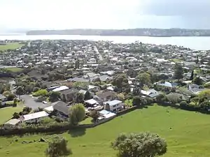
Māngere Bridge, New Zealand
Māngere Bridge is an Auckland suburb under the local governance of the Auckland Council, at the south end of Mangere's bridge over the Manukau Harbour.
Mangere Bridge | |
|---|---|
Suburb | |
 Western part of the suburb seen from Mangere Domain. | |

| |
| Country | New Zealand |
| Local authority | Auckland Council |
| Electoral ward | Manukau Ward |
| Local board | Māngere-Ōtāhuhu Local Board |
| Population (2018)[1] | |
| • Total | 10,296 |
| (Manukau Harbour) | (Manukau Harbour) | (Mangere Inlet) |
| (Manukau Harbour) |
|
Favona |
| (Manukau Harbour) | Māngere | Favona |
It includes Māngere Mountain and is close to the Ambury Farm Park run by the Auckland Council.[2]
It is a multicultural area, often with large families, with the suburb dominated by brick-and-tile homes built in the 1960s–1970s.[2]
In 2019, the name of the suburb was officially gazetted as Māngere Bridge.[3]
Demographics
| Year | Pop. | ±% p.a. |
|---|---|---|
| 2006 | 8,802 | — |
| 2013 | 9,261 | +0.73% |
| 2018 | 10,296 | +2.14% |
| Source: [1] | ||

Māngere Bridge, comprising the statistical areas of Māngere Bridge Ambury, Māngere Bridge and Māngere Mountain View, had a population of 10,296 at the 2018 New Zealand census, an increase of 1,035 people (11.2%) since the 2013 census, and an increase of 1,494 people (17.0%) since the 2006 census. There were 3,150 households. There were 5,052 males and 5,244 females, giving a sex ratio of 0.96 males per female, with 2,343 people (22.8%) aged under 15 years, 1,944 (18.9%) aged 15 to 29, 4,650 (45.2%) aged 30 to 64, and 1,365 (13.3%) aged 65 or older.
Ethnicities were 54.6% European/Pākehā, 18.9% Māori, 32.3% Pacific peoples, 13.1% Asian, and 2.2% other ethnicities (totals add to more than 100% since people could identify with multiple ethnicities).
The proportion of people born overseas was 27.0%, compared with 27.1% nationally.
Although some people objected to giving their religion, 35.2% had no religion, 50.7% were Christian, and 7.6% had other religions.
Of those at least 15 years old, 1,788 (22.5%) people had a bachelor or higher degree, and 1,401 (17.6%) people had no formal qualifications. The employment status of those at least 15 was that 4,257 (53.5%) people were employed full-time, 927 (11.7%) were part-time, and 354 (4.5%) were unemployed.[1]
Marae
Te Puea Marae, the local marae, is a tribal meeting ground for the Waikato Tainui hapū of Ngāti Kuiaarangi, Ngāti Mahuta, Ngāti Tai and Ngāti Whāwhākia. It includes a meeting house, also called Te Puea.[4][5] The marae has helped hundreds of homeless people find housing, through a philosophy of manaakitanga.[6]
Education
Mangere Bridge School, Waterlea Public School and Mountain View School are contributing primary schools (years 1–6) with rolls of 387, 437 and 224 students, respectively.[7][8][9]
Ambury Park Centre is a private secondary school (years 9–13) for students with disabilities. It has a roll of 12 students.[10] Horse riding and care of horses are an important feature of their educational programme.[11]
Auckland Seventh-day Adventist High School is a state-integrated secondary school (years 9–13) with a roll of 291 students.[12]
All these schools are coeducational. Rolls are as of March 2020.[13]
Association football
Mangere Bridge is home to Onehunga-Mangere United football club.
Notable residents
- David Lange ONZ CH – Former Prime Minister
- Hon Willie Jackson – Politician, Broadcaster
- Jon Zealando – Magician
- Mike King ONZM – Comedian and Mental Health Advocate
References
- "Statistical area 1 dataset for 2018 Census". Statistics New Zealand. March 2020. Māngere Bridge Ambury (146100), Māngere Bridge (146800) and Māngere Mountain View (147500). 2018 Census place summary: Māngere Bridge Ambury 2018 Census place summary: Māngere Bridge 2018 Census place summary: Māngere Mountain View
- "Mangere – Property". The New Zealand Herald. 7 May 2005. Retrieved 7 February 2011.
- "Place name detail: Māngere Bridge". New Zealand Gazetteer. New Zealand Geographic Board. Retrieved 2 August 2019.
- "Te Kāhui Māngai directory". tkm.govt.nz. Te Puni Kōkiri.
- "Māori Maps". maorimaps.com. Te Potiki National Trust.
- Nielson, Michael (19 September 2018). "Te Puea Marae model of manaakitanga 'key' to tackling homelessness crisis". New Zealand Media and Entertainment. New Zealand Herald.
- Education Counts: Mangere Bridge School
- Education Counts: Waterlea Public School
- Education Counts: Mountain View School
- Education Counts: Ambury Park Centre
- "Secondary School". Ambury Park Centre. Retrieved 18 August 2020.
- Education Counts: Auckland Seventh-day Adventist High School
- "New Zealand Schools Directory". New Zealand Ministry of Education. Retrieved 26 April 2020.
External links
- Mangere Bridge community site
- Mangere Bridge Business Community site
- Photographs of Māngere Bridge held in Auckland Libraries' heritage collections.