List of castles in Cheshire
There are 20 castles in the county of Cheshire in North West England.[1]
.jpg.webp)
Introduction
Cheshire is one of the historic counties of England and its historic boundaries are different from the modern county lines. Some castles that were formerly in Cheshire are now in Greater Manchester. In addition, Warrington Castle is historically a part of Lancashire but is within the current boundaries of Cheshire. Before the Norman conquest of England began in 1066, defensive sites in England were communal, such as Anglo-Saxon burhs built as a defence against the Danes. Castles were popularised in England by the Normans – although a few sites in the south-east pre-dating the Norman conquest – and were owned by the feudal lords. The primary purpose of a castle was military: to be used as a base of operations and to control the surrounding areas.[2] A castle was considered to be a stamp of authority over the population of an area, and a status symbol. Some would have acted as centres of trade and administration for a manor.[3]
Castles can take several forms. The most common is the motte-and-bailey[4] which consists of a motte (a mound) – surmounted by a keep or tower – connected to a bailey, an outer enclosure where the barracks and workshops were located.[5] Other types of castle in Cheshire are ringworks and fortified manor houses. Ringworks are similar to motte-and-bailey castles but lack the motte;[6] although contemporary with motte-and-baileys, they are an uncommon form of fortification. A ringwork may have been built rather than a motte-and-bailey because the soil was too thin to provide a proper motte or simply because of the preference of the builder.[7] A fortified manor house was the administrative centre of a manor – a division of land in medieval England – and was usually the home of the local lord.[8] Fortified manor houses are considered castles because they often had battlements or crenellations.[9]
Due to its border with Wales, Cheshire played an important role in defending England against the Welsh. Many castles were built along the border,[10] and 8 of the 20 castles in Cheshire are within 4 miles (6.4 km) of the Welsh border. Castles along the border were constructed when the Norman invasion of Wales was slowed by Welsh opposition; when conquest was swift, there was less need for fortifications.[11] Compared to north Wales, relatively few castles are found in Cheshire since many, such as Holt Castle, were built on the western side of the River Dee. Most of these castles were motte-and-baileys and were originally of turf and timber construction, although they were sometimes later replaced by stone structures if a long-term castle was needed.[11] Away from the borders, baronial castles were built in Cheshire and were a status symbol.[12] The castles in Cheshire were built over a period of several centuries, with the earliest in 1070 and the latest in the 15th century. Most, 12 out of 20, were built between 1070 and the end of the 12th century. Of the three castles in Cheshire known to have been built after the 13th century, they are either tower houses or fortified manor houses; this type of structure was more important as a feudal residence than a military structure and reflects the national trend of castles after the 13th century being used as a symbol of authority rather than primarily military.[13]
Most of the castles are in a ruinous state, having been abandoned after they fulfilled their military purpose. The remains are often protected by law: 11 sites are Scheduled Monuments, and 5 are listed buildings. A Scheduled Ancient Monument is a "nationally important" archaeological site or historic building, given protection against unauthorised change.[14] As well as the 20 known castles in Cheshire, historian Mike Salter in his 2001 gazetteer of the castles in Cheshire and Lancashire lists Mud Hill in Coddington (53.091352°N 2.817631°W) and Peel Hall near Manley (53.221258°N 2.7497°W) as possible sites of castles.[15]
List of castles
| Castle | Location | Type | Constructed | Scheduled Monument | Notes |
|---|---|---|---|---|---|
| Aldford Castle | Aldford 53.1304°N 2.8698°W |
Motte-and-bailey and shell keep[16] | 12th century[16] | Yes[17] | The motte, which survives to a height of 5.2 m (17 ft), is surrounded by a 10 m (33 ft) wide and 2.4 m (7 ft 10 in) deep ditch. The bailey is surrounded by a 2 m (6 ft 7 in) deep 18 m (59 ft) wide ditch,[16] and is triangular in shape, covering an area of 4,250 m2 (45,700 sq ft). A later manor house was probably built on the motte.[17] |
| Beeston Castle | Beeston 53.127894°N 2.690455°W[18] |
Enclosure[19] | 1220s[20] | Yes[18] | Beeston Castle is on a crag 90 m (300 ft) above the surrounding countryside, at the northern end of the Peckforton Hills. The site is strategically strong because of its natural defences and overlooks the surrounding area for miles.[19] It has an outer and inner bailey and no motte; this, coupled with strong defensive walls and gatehouse and no inner keep means it is an enclosure type castle.[21] The inner bailey is surrounded by a sheer drop on three sides, and is protected by a 9 m (30 ft) deep ditch on the fourth side. The curtain wall of the outer bailey was 2 m (6 ft 7 in) thick.[22] It was built in the 1220s by Ranulf de Blondeville, 6th Earl of Chester,[20] and is similar in design to Bolingbroke Castle in Lincolnshire which he built around the same time.[23] The castle passed into the possession of the Crown when John le Scot, Blondeville's heir, died in 1237. Beeston Castle was involved in the Second Barons' War (1264–1265) when it was captured by Prince Edward from Simon de Montfort, 6th Earl of Leicester.[23] In the English Civil War it was captured by the Parliamentarians and then recaptured by the Royalists before being slighted in 1646 to render its defences useless.[24][25] The castle is protected as a Grade I listed building and is now a museum.[25] |
| Bradlegh Old Hall | Burtonwood 53.4399°N 2.6463°W[26] |
Fortified manor house[26] | 15th century[26] | Yes[27] | The hall was built as a manor house in the 15th century with a moat and a fortified gatehouse.[26] It was owned by the Legh family who owned Lyme Park.[27] Additions were made in the 16th century, and the structure was encased in brick in the 18th century. The ruinous gateway, which was built in 1460, is a Grade II* listed building. Only the gateway and moat survive from the 15th century hall.[26] |
| Chester Castle | Chester 53.185091°N 2.890729°W[28] |
Motte-and-bailey (also a possible ringwork) | 1070[28] | Yes[28] | Chester Castle was built in 1070 by William the Conqueror. Originally a motte-and-bailey castle constructed from timber and turf, it was rebuilt in stone in the 12th century. The castle underwent many periods of construction, with an outer bailey, new towers along the inner bailey, new structures within the castle walls, and a new gatehouse all added in the 13th century, during the Welsh Wars.[28] Chester Castle was given by William I to the Earls of Chester and it served as the administrative centre of the earldom. It passed into the possession of the Crown on the extinction of the line of earls in 1237. After the 13th century, most expenditure on the castle was to maintain it rather than aggrandise it as happened with other castles such as Warwick Castle. When the medieval castle was destroyed by fire in the 18th century, only the Agricola Tower survived. The tower (also known as Caesar's Tower) and the curtain walls are Grade I listed buildings.[28] |
| Doddington Castle[A] | Doddington 53.019424°N 2.434224°W[29] |
Tower house[29] | 1364–1403[29] | No | Doddington Castle was built in 1364–1403 by Sir John Delves. He acquired a licence to crenellate and erected a free-standing tower separate from his mansion. In the 17th century, the tower was incorporated into a series of domestic houses. When these houses were demolished in 1777, the tower was retained as a landscape feature. The castle is three storeys high and made from sandstone. It is protected as a Grade I listed building.[29] |
| Dodleston Castle | Dodleston 53.140902°N 2.954703°W[30] |
Motte-and-bailey[30] | Medieval[31] | Yes[31] | The 3.3 m (11 ft) high motte is surrounded by a 2.3 m (7 ft 7 in) deep ditch.[30] The bailey, to the west of the motte, is surrounded by a rampart and ditch; the ditch is 12 m (39 ft) wide and is up to 2.4 m (7 ft 10 in) deep, while the rampart survives to a height of 1.5 m (4 ft 11 in).[32] Dodlestone Castle was the seat of the Boydell family. The site has been damaged by landscaping and construction work.[30] A later mansion was built on the site for the Manley family of Lache, and this building was probably used in the English Civil War as Sir William Brereton's headquarters during the Siege of Chester.[32] |
| Frodsham Castle | Frodsham 53.29236°N 2.729414°W[33] |
Unknown[33] | 1070[34] | No | Frodsham Castle is located at the foot of Overton Hill in the western part of the town of Frodsham. It guarded a pass between the hill and Frodsham Marsh. The castle was probably built by Hugh Lupus, the first Earl of Chester.[34] In 1355, Frodsham Castle was recorded as requiring repair. The Norman castle collapsed in the 14th century and was replaced by a fortified manor house.[34] This was destroyed by fire in 1654. Although there are no visible traces of the structure, some of the foundations were incorporated into the cellars of Castle Park, a building constructed on the site in 1721.[33] |
| Halton Castle | Halton, Runcorn 53.332844°N 2.694361°W[35] |
Motte-and-bailey[36] | c. 1070[36] | Yes[36] | Halton Castle is on the summit of Halton Hill and overlooks the estuary of the River Mersey.[37] Halton Castle was probably built in the late 11th century for Nigel of Cotentin, the first Baron of Halton. The first timber castle was replaced by the current stone structure in the 12th century.[38][39][40] The castle passed into the possession of the crown when the 15th baron, Henry Bolingbroke, ascended to the throne as Henry IV.[41] Although used as a prison and centre of administration in the Tudor period, by 1609 the structure was in a state of disrepair.[42][43][44] The castle was used in the English Civil War, but afterwards its defences were dismantled.[45] After that, the castle was allowed to deteriorate. The ruins of the castle are protected as a Grade I listed building.[46] |
| Kingsley Castle[B] | Manley 53.2558°N 2.6998°W[47] |
Motte[32] | Medieval, possibly Norman[32] | Yes[32] | The motte survives to a height of 2.8 m (9 ft 2 in) and is 23 m (75 ft) in diameter.[32] There is no trace of a surrounding ditch or a bailey associated with the motte.[32][47] There are the remains of a summerhouse on the side of the motte, not contemporary with the medieval castle.[47] |
| Macclesfield Castle[C] | Macclesfield 53.258926°N 2.12421°W[48] |
Fortified manor house[48] | 1398[49] | No | Located in the town of Macclesfield, the castle was built by John de Macclesfield in the late 14th–early 15th century, probably because of the crisis towards the end of Richard II's reign.[49] The castle was square with projecting wings, and measured 130 by 36 metres (142 by 39 yd). After de Macclesfield died in 1422, the castle passed through the possession of two families of earls, one of which was the Earl of Buckingham's family, after which the castle became known as Buckingham Palace. It was altered in the 15th century, and by 1585 was ruinous.[50] By the 20th century, only the porch was still standing, and this was demolished in 1932 and shops and cottages were built on the site.[48] |
| Malpas Castle[D] | Malpas 53.019549°N 2.765804°W[51] |
Motte[51] | Probable 12th century | Yes[51] | Malpas Castle is in the Broxton Hills and was built for the Barons of Malpas.[52] It was part of a series of defences along the Welsh border, and was linked with Aldford and Shocklach castles (Shocklach was also built by the Barons of Malpas).[53][54] Its links with Alford and Shocklach castles and the Barons of Malpas means it was probably built in the 12th century. The motte survives to 3.7 metres (12 ft) in height and is 37 m (40 yd) in diameter and is surrounded by a ditch.[51] Although there is no sign of a bailey, there was probably one to the south of the motte; the site today is heavily disturbed and covered in grass.[51][54] |
| Nantwich Castle | Nantwich 53.066452°N 2.521413°W[55] |
Unknown[55] | Before 1180[56] | No | Nantwich Castle lay in ruins by 1485. No trace survives, and Castle Street and Mill Street are on the site.[55] |
| Newhall Tower | Newhall 53.0046°N 2.5820°W[57] |
Tower house[58] | c. 1227[58] | No | Newhall Tower was probably built in 1227 for the Audley family when they gained ownership of the land, but it is first documented in 1275. It was still in use in 1363, but was ruinous by the late 16th century. The site of the castle is uncertain, but a series of earthworks with a central mound and a square ditch is the likeliest location.[58] |
| Northwich Castle | Northwich 53.259°N 2.518°W[57] |
Motte[57] | Probable 12th century[57] | No | The castle is first referred to in the 1190s, and again in 1278. Excavations have not revealed the location of the castle.[57] |
| Oldcastle | Oldcastle 52.991681°N 2.792876°W[59] |
Unknown[59] | 13th century[59] | No | The first documented evidence of Oldcastle comes from 1288. By 1485, the castle was ruinous. Little is known about the castle, although it was surrounded by two defensive ditches. One ditch began silting up in the 13th century and was filled in during the late 14th–early 15th centuries, while the other was in use until the 15th century.[59] |
| Pulford Castle | Pulford 53.121069°N 2.933267°W[60] |
Motte-and-bailey[60] | Late 12th century[60] | Yes[60] | Pulford Castle is first documented in 1190–1220.[60] Having been built by the Ormesbee family, the castle was given to the Pulford family in 1245. In 1403, Henry IV ordered Sir Thomas le Grosvenor to hold the castle against Owen Glendower.[61] The motte is surrounded by a ditch apart from in the south, where Pulford Brook forms part of the defences.[60] The motte survives to a height of 3 m (9.8 ft) and measures 11 by 9 m (36 by 30 ft) at the summit.[61] In 1313, a jury of the Chester county court found that the lord of Little Caldy (Wirral) held that manor by the service of 'palisading' (i.e. repairing the wooden defences) of Robert de Pulford's castle at Pulford.[62] |
| Shipbrook Castle | Davenham 53.235692°N 2.489153°W[63] |
Unknown[63] | 11th–12th centuries[63] | No | The exact location of Shipbrook Castle is uncertain, but it is thought to be on Castle Hill near Shipbrook Bridge. During the Welsh Wars, baronial castles were built as a form of defence, and Shipbrook Castle was one of these. It was demolished in around 1850.[63] |
| Shocklach Castle | Shocklach 53.051612°N 2.843735°W[53] |
Fortified manor house[54] | 1100[53] | Yes[53] | Shocklach Castle is on the edge of a steep ravine. The earliest fortification on the site is a motte surrounded by a ditch; the motte survives to a height of 4 m (13 ft) from the bottom of the ditch.[53] Although there is no bailey connected to the motte, there is a D-shaped enclosure 30 m (98 ft) east of the motte.[54] The enclosure near the motte was the site of a fortified manor house and was surrounded by a moat; it was the successor fortification from the earlier motte and it thought to have been built around 1100 for the Barons of Malpas.[54] Shocklach Castle was part of a series of defences along the Welsh border,[53] and was linked with Aldford and Malpas castles.[53][54] |
| Shotwick Castle | Shotwick 53.226871°N 2.974293°W[64] |
Motte-and-bailey[64] | Probably pre-1093[64] | Yes[64] | It is located on a steep escarpment which was on the shore of the Dee estuary when the castle was built; it is protected by streams on two sides and guarded a ford over the River Dee.[64] The motte is an irregular hexagon and measures 40 m (130 ft) north-south and 20 m (66 ft) east-west. A kidney-shaped bailey next to the motte measures 80 m (260 ft) north-south and 38 m (125 ft) east-west. A ditch surrounds the bailey varying between 15 and 29 m (49 and 95 ft) wide and 2.2 to 3.8 m (7 ft 3 in to 12 ft 6 in) deep. Shotwick Castle was probably built by Hugh Lupus, 1st Earl of Chester, in the late 11th century, although the castle was first documented in 1260.[64] It was used as border defence against the Welsh until peace was achieved in 1281. After this, it fell out of use as a military castle, and became part of a royal manor and game park for Edward III. Shotwick Castle was ruinous by 1621 and demolished in 1756. The castle survives as earthworks but has been damaged by treasure hunters and ploughing, and is now used as pasture.[64] |
| Warrington Castle[E] | Warrington 53.392°N 2.576°W[65] |
Motte-and-bailey[65] | Medieval, possibly Norman[65] | No | Warrington Castle is on a slight prominence 230 m (250 yd) north of the bank of the River Mersey, overlooking a ford and its approaches. The motte was surrounded by a ditch and oval in shape, measuring 49 by 39 m (161 by 128 ft) and survives to a height of 2.7 m (8 ft 10 in) in 1908.[65] The bailey was defended by a rampart and ditch. It was probably built in the Norman period, and the residence of the Lords of the Manor of Warrington until they moved to Bewsey Hall in Burtonwood. Warrington Castle was the largest motte-and-bailey castle in Lancashire. By 1587, the castle was in a state of decay. Although the site was reused in the English Civil War, it otherwise slips out of records after 1587 and was probably left derelict. No trace of the castle remains, and the site is occupied by a park.[65] |
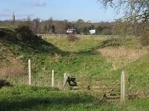 Earthworks are all that remains of the 12th century Aldford Castle
 Beeston Castle viewed from the south, built on a rocky summit 110 m (360 ft) above the Cheshire Plain
 Engraving of Beeston Castle in 1727 by the Buck Brothers, showing Beeston Castle from the south.[66] By this time, the castle defences had been dismantled to render it strategically useless
 Beeston Castle gateway to the main keep
 An engraving by Buck Brothers of Chester Castle in 1747
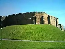 The curtain walls of Chester Castle
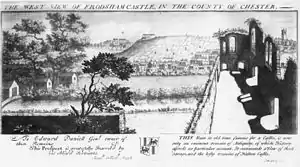 Ruins of Frodsham Castle in the 18th century
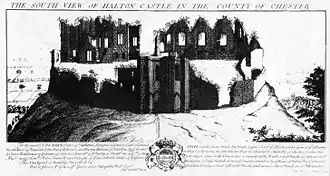 Halton Castle in 1727. Engraving by the Buck brothers
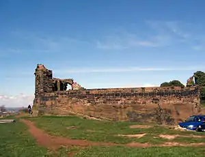 Part of the ruins of Halton Castle in 2006
 Only earthworks survive of Shotwick Castle
Alternative names
Some of the castles in the list have more than one name. Where this is the case, the alternative names are listed here.
See also
References
- Salter (2001), pp. 9–39.
- Friar (2003), p. 54.
- Friar (2003), pp. 186, 193.
- Rowley (1997), p. 71.
- Friar (2003), pp. 22, 214.
- Friar (2003), p. 246.
- Grimsditch, Nevell, and Redhead (2007), p. 10.
- Friar (2003), p. 186.
- Friar (2003), pp. 84, 186–187.
- Husain (1973), p. 97.
- Husain (1973), pp. 100–101
- Husain (1973), p. 101
- Friar (2003), pp. 57, 70.
- Scheduled Monuments, Pastscape.org.uk, retrieved 27 July 2011
- Salter (2001), p. 21.
- Aldford Castle, Pastscape, archived from the original on 30 July 2012, retrieved 12 April 2009
- Motte & Bailey Castle, Aldford, Revealing Cheshire's Past, retrieved 12 April 2009
- Beeston Castle, Pastscape.org.uk, retrieved 22 March 2009
- Hough (1978), p. 1.
- Fry (1980), p. 191.
- Hough (1978), pp. 1–2.
- Beeston Castle: Information for Teachers (PDF), English Heritage, archived from the original (PDF) on 11 March 2008, retrieved 17 March 2008
- Hough (1978), p. 2.
- Dore (1996), p. 33.
- Historic England, "Beeston Castle (1330329)", National Heritage List for England, retrieved 12 April 2009
- Bradlegh Old Hall, Pastscape, archived from the original on 13 July 2012, retrieved 10 April 2009
- Bradlegh Old Hall moated site and fishpond, Revealing Cheshire's Past, retrieved 10 April 2009
- Chester Castle, Pastscape.org.uk, retrieved 22 March 2009
- Delves Hall, Pastscape.org.uk, retrieved 22 March 2009
- Monument no. 67014, Pastscape.org.uk, retrieved 22 March 2009
- Dodlestone Castle, Revealing Cheshire's Past, retrieved 10 April 2009
- Castle Cob Motte, Revealing Cheshire's Past, retrieved 10 April 2009
- Monument no. 71545, Pastscape.org.uk, retrieved 22 March 2009
- Latham (1987), p. 20.
- Halton Castle, Pastscape.org.uk, retrieved 22 March 2009
- Halton Castle: ruined shell keep castle on site of motte & bailey, Revealing Cheshire's Past, retrieved 11 April 2009
•Halton Castle: ruined shell keep castle on site of motte & bailey, Revealing Cheshire's Past, retrieved 21 January 2009
•Halton Castle: ruined shell keep castle on site of motte & bailey, Revealing Cheshire's Past, retrieved 21 January 2009 - Halton Castle, Pastscape, retrieved 11 April 2009
- McNeil (1987), p. 1.
- Starkey (1990), p. 19.
- Whimperley (1981), p. 3.
- Starkey (1990), p. 32.
- McNeil (1987), p. 7.
- Nickson (1887), p. 148.
- Starkey (1990), p. 28.
- Starkey (1990), p. 58.
- Historic England, "Halton Castle (1130460)", National Heritage List for England, retrieved 11 April 2009
- Castle Cob, Pastscape, archived from the original on 17 July 2012, retrieved 10 April 2009
- Macclesfield Castle, Pastscape.org.uk, retrieved 16 March 2009
- Turner (1987), p. 137.
- Turner (1987), p. 138.
- Castle Hill, Pastscape.org.uk, archived from the original on 14 July 2012, retrieved 17 March 2009
- Castle Hill motte, Malpas, Revealing Cheshire's Past, retrieved 23 January 2009
- Shocklach Castle, Pastscape, archived from the original on 17 July 2012, retrieved 10 March 2009
- Shocklach Castle motte, Cheshire.gov.uk, retrieved 10 March 2009
- Monument no. 72713, Pastscape.org.uk, retrieved 22 March 2009
- McNeil Sale R.; et al. (1978), Archaeology in Nantwich: Crown Car Park Excavations, Bemrose Press, p. 14
- Salter (2001), p. 20.
- Newhall Tower, Pastscape.org.uk, retrieved 9 April 2009
- Castle Hill, Pastscape.org.uk, retrieved 22 March 2009
- Monument no. 66937, Pastscape.org.uk, retrieved 21 March 2009
- Pulford Motte and Bailey Castle, Revealing Cheshire's Past, retrieved 12 April 2009
•Pulford Motte and Bailey Castle, Revealing Cheshire's Past, retrieved 12 April 2009
•Pulford Motte and Bailey Castle, Revealing Cheshire's Past, retrieved 12 April 2009 - TNA CHES 29/27 m 6d
- Shipbrook Castle, Pastscape.org.uk, retrieved 22 March 2009
- Shotwick Castle, Pastscape, archived from the original on 16 July 2012, retrieved 6 March 2009
- The Mount, Pastscape, retrieved 9 April 2009
- Ormerod (1882)
- Bibliography
- Friar, Stephen (2003), The Sutton Companion to Castles, Stroud: Sutton Publishing, ISBN 978-0-7509-3994-2
- Fry, Plantagenet Somerset (1980), The David & Charles Book of Castles, David & Charles, ISBN 0-7153-7976-3
- Grimsditch, Brian; Nevell, Mike & Redhead, Norman (September 2007), Buckton Castle: An Archaeological Evaluation of a Medieval Ringwork – an Interim Report, University of Manchester Archaeological Unit
- Hough, P.R. (1978), "Excavations at Beeston Castle, 1975–1977", Journal of the Chester Archaeological Society, 61: 1–24
- Husain, B.M.C. (1973), Cheshire Under the Norman Earls 1066–1237, Cheshire Community Council
- Latham, Frank A. (1987), Frodsham: The History of a Cheshire Town, Local Historians, ISBN 0-901993-06-9
- McNeil, Robina (ed.) (1987), Halton Castle: A Visual Treasure, Halton Castle: A Visual Treasure: North West Archaeological TrustCS1 maint: extra text: authors list (link)
- Nickson, Charles (1887), History of Runcorn, London: Mackie & Co.
- Ormerod, G. (1882), Helsby, T. (ed.), History of the County Palatine and City of Chester (2nd ed.)
- Rowley, Trevor (1997), Norman England, Batsford and English Heritage, ISBN 0-7134-8060-2
- Salter, Mike (2001), The Castles and Tower Houses of Lancashire and Cheshire, Folly Publications, ISBN 1-871731-51-8
- Starkey, H. F (1990), Old Runcorn, Halton Borough Council
- Turner, R.C. (1987), "Macclesfield Castle", Transactions of the Ancient Monuments Society, 31: 134–145
- Whimperley, Arthur (1981), Halton Castle: An Introduction & Visitors' Handbook, Widnes: Arthur Whimperley
Further reading
- Swallow, Rachel (2016), "Cheshire Castles of the Irish Sea Cultural Zone", The Archaeological Journal, 173 (2): 288–341, doi:10.1080/00665983.2016.1191279